| where | Location of the marine reserve near Leigh and how to get there. Weather conditions, visibility and currents. Feeding the fishes? (on this page, 10 pages) | |
| history | History of the marine reserve and what it has been used for. (on this page) | |
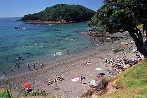
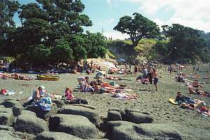
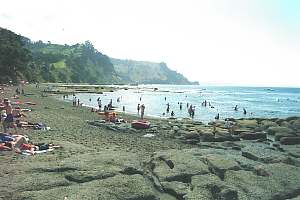
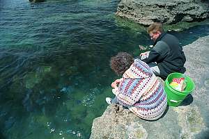
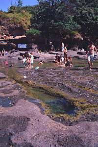
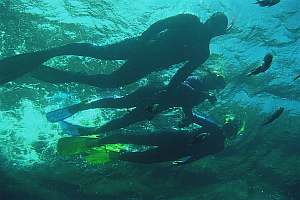
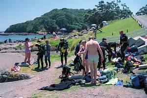
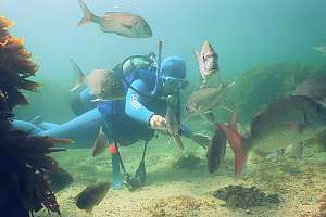
| a sunny day | Pictures of what people do on a sunny day. (on this page) | |
| environment | The marine habitats found inside and outside the reserve, with an introduction to the marine life found in each, with many photographs. Habitat zoning, the shallow bladderweed zone, the barren zone, the kelp forest, the deep reef, the sand. (16 pages) | |
| special cases | Special cases of the marine environment with many photographs: sponge gardens, intertidal, shell trap, mussel bank, caves, promontories, shelter, night shift and biogeography. (18 pages) | |
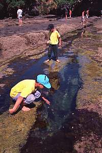
| rocky shore | The intertidal rocky shore habitat; what lives there, where and why. (80 pages) | |
| monitoring | Results of scientific monitoring and research, including anecdotal observations (10 pages) | |
| dive spots | Descriptions of good dive spots inside the marine reserve. Maps, habitat photos (17 pages) | |
| In the summer we take a photo every morning at around 8 AM of the Goat Island beach and channel, and make predictions for the coming week. | ||
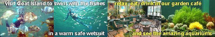
 Visit the
Seafriends
Marine Conservation and Education Centre at the beginning of
the Goat Island Road for all your snorkelling and diving needs. Great quality
at affordable prices. Hire a safe, warm, floating wetsuit. Submerge yourself
in the marine information centre with an extensive marine library, informative
posters, extensive underwater photo collections, and an ecosystem-based
marine aquarium. Great coffees and lunches too! Help us to save our seas! Visit the
Seafriends
Marine Conservation and Education Centre at the beginning of
the Goat Island Road for all your snorkelling and diving needs. Great quality
at affordable prices. Hire a safe, warm, floating wetsuit. Submerge yourself
in the marine information centre with an extensive marine library, informative
posters, extensive underwater photo collections, and an ecosystem-based
marine aquarium. Great coffees and lunches too! Help us to save our seas! |
||
| The Fishes of Goat Island: common fishes found in the marine reserve with narrative & captions (27 mins) | ||
| further reading | Books and references for further reading. (on
this page)
What's new: a chronology of changes to this section. (on this page) |
|
| other maps
& photos |
Maps and photos not appearing in the text:
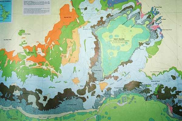
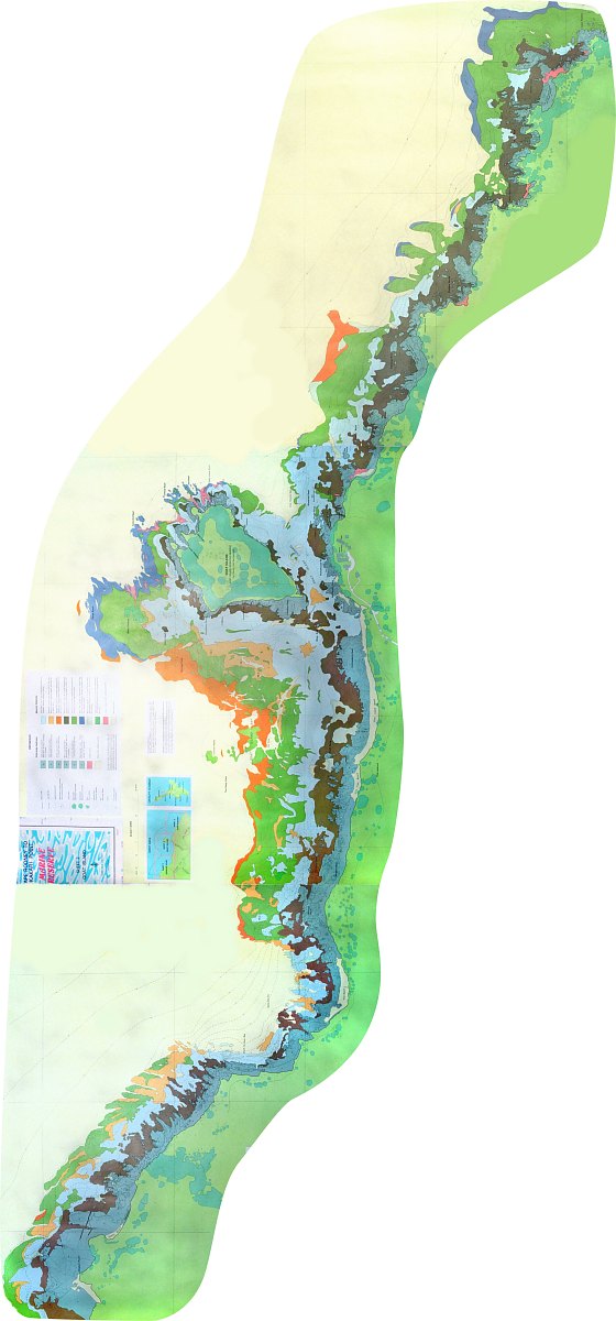
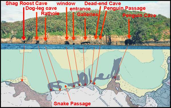
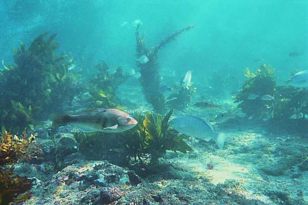
Helicopter view of the Goat Island Channel, main snorkel area, Echinoderm Reef, beach and parking. Topographical map of the Leigh area including Leigh, Cape Rodney and the marine reserve. Overview map of the sea around Goat Island, with place names and habitat key. Habitat map of the area around and west of Goat Island, corresponding to map No 2. Composite map of the whole marine reserve, corresponding to maps No. 1, 2, 3. (100KB) Cave exploration: a network of interconnecting caves, at Goat Island's east coast. Fish lazing in the shelter provided by Goat Island, a magical moment, which is becoming rare |
|
| related pages
on this site |
Related pages on this web site:
Marine reserves: paradise won or lost? Marine reserves do not measure up to their expectations. Why? (17 p) Lessons from Leigh: where the reserve succeeded and where it failed. Degradation and threats. (21 pages) Marine Conservation: the principles of marine conservation; what works and what does not. (30 pages) Marine habitats: an introduction to marine habitats, limiting factors and what it would be like to live there. (14 pages) To feed or not? Is fish feeding inside a marine reserve a bad thing to do? The inside story. (7 pages) The war for marine reserves: the NZ Government is waging a war for marine reserves in the belief that marine reserves can save the environment, but this cannot be so, in the face of accelerating marine degradation. (large section) Marine degradation: become aware of what is really happening to our seas and why, with facts and data. (large) Transcripts of speeches during the official opening of the marine reserve, 25 May 1977. (14 pages) View from the bridge, a transcript of a video, interviewing stakeholders in 3 NZ marine reserves, in 1999. (11 pages) Snorkelling without fear: essential snorkel instruction for beginner and advanced (17 pages) |
|
| links | Leigh Marine Laboratory: research topics, recent publications and reports. |
For best printed results, set your left margin to 0.3"
and right margin to 0.2". This section contains over 190 files, about 3.5MB.
For corrections, suggestions and improvements, please
e-mail
me.
-- home -- conservation
issues -- marine reserves -- site
map -- Rev: 19971012, 20021220, 20030116,
Where to find the reserve
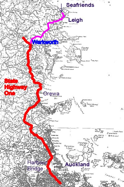 The
trip from Auckland to Leigh leads over State Highway One north till Warkworth
and then east past Matakana to Leigh. It takes about 90 km, or just over
one hour to get there by car. The
trip from Auckland to Leigh leads over State Highway One north till Warkworth
and then east past Matakana to Leigh. It takes about 90 km, or just over
one hour to get there by car.
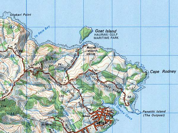
In Leigh turn north towards Pakiri on the Leigh-Pakiri Road, then after 1.5km turn right into Goat Island Road. At the beginning of this road you'll pass the Seafriends Marine Conservation and Education Centre who also hire all you need for diving and snorkelling. At the end of the road is the Marine Laboratory of the University of Auckland, which is not where you want to end up. Before the little bridge at the beach you'll find ample parking space. Make sure to lock your vehicle securely and take some effort to lock valuables into the boot of your car, which is more difficult to break in to. |
 |
 |
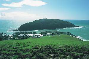 |
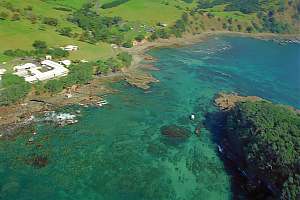
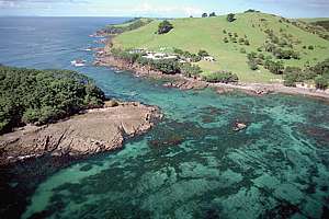
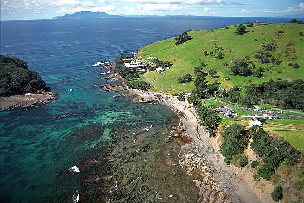
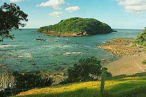
f992318: an aerial view looking west over the Goat Island Channel. On left the marine laboratory complex. |
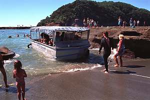
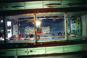
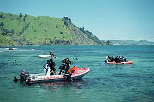
 Most
diving in the reserve is done straight from the beach, in the shelter provided
by Goat Island. Goat Island itself is a terrestrial island reserve, belonging
to the Hauraki Gulf Maritime Park. Landing on the island is prohibited
but you may safely rest on its rocky platforms. The Goat Island Channel
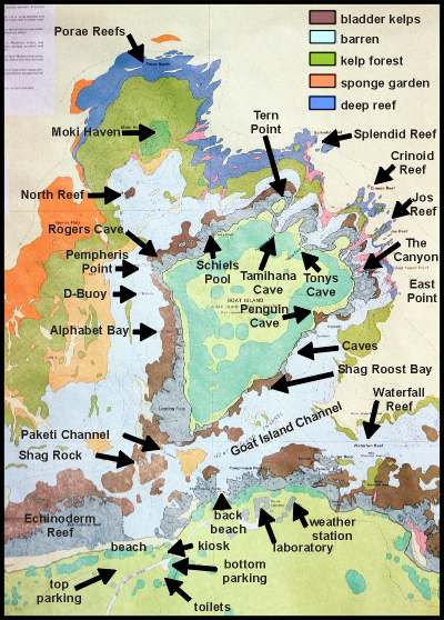
is not deep (between 2 and 5 m), which suits young snorkeldivers. Click
on the map for a topographical map of the area. Most
diving in the reserve is done straight from the beach, in the shelter provided
by Goat Island. Goat Island itself is a terrestrial island reserve, belonging
to the Hauraki Gulf Maritime Park. Landing on the island is prohibited
but you may safely rest on its rocky platforms. The Goat Island Channel
is not deep (between 2 and 5 m), which suits young snorkeldivers. Click
on the map for a topographical map of the area.
You may find a slight current running in the channel. For snorkeldivers this current is seldom inconvenient but in extreme circumstances, divers may find it difficult to swim against. The direction of this current is totally unpredictable. In very calm weather it is supposed to run west-east at the rising tide and east-west at the receding tide. (The main currents fill and drain the Hauraki Gulf basin to the south-east). But an eddy is formed north of Cape Rodney, which reverses this scheme. However, the most important influence on this current is the wind. When blowing from the north to west, it sweeps a current down the Pakiri Beach which pushes itself around Goat Island and through the channel. So watch out for strong NW winds. |
Underwater visibility is highly variable. In general the months
January to June will give clearest waters with up to 15m visibility. But
a rainstorm or storm is sufficient to put an end to that. Although the
watershed area draining into the marine reserve is very small, rainstorms
are by far the most important cause of turbidity. In the months of October
to December when the water starts to warm up, plankton blooms are common.
In some years they may reduce underwater visibility to less than 2m. Normal
visibility for the reserve is around 6m. Easterly winds appear to improve
visibility by blowing the turbid and warmer surface water out to sea. It
is replaced by colder, clearer water from deeper layers in the sea. It
pays to swim out from the beach towards the island, in order to escape
the murky fringe that is either stirred up by thousands of feet or flows
out from the little creek. Summarising, your best bets are for sunny days
with little wind or S-W winds, with at least a week since the last rain
storm.
 |
 |
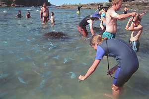
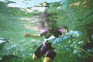
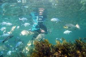
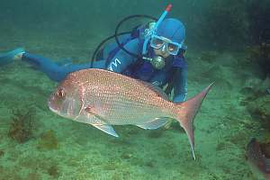
Officially you are not allowed to feed the fish. The reasons for this is that feeding the fish, influences the environment. It draws fish from afar, resulting in an unsustainable overpopulation near the beach. Fish learn strange habits such as eating the wrong food and eventually biting swimmers' hands while begging. It spoils the fun for underwater photographers who wish to photograph the underwater creatures in their natural behaviors. Feeding turns a wilderness area into an urban park. In the summer holidays, the sheer number of people causes a food binge, leaving undigested and digested matter floating near the beach. It could in fact become a health hazard, to both fish and people. Yet people arrive from far afield and instead of asking the way to the marine reserve, they ask: "Where can I feed the fishes?".
Let's be reasonable about feeding the fish. Obviously people have a need to make a friendly gesture and indeed it has helped to tame the fish, resulting in more enjoyment for everyone. Problems arise from the quantity fed out and from how and where the fish are fed. The best thing would be to feed the fish from the rocks or while standing in the water as a snorkeldiver. Under no circumstance must SCUBA divers feed the fish! Fish will quickly learn the difference between swimmers and SCUBA divers, and the areas further away from the beach will at least not be spoiled this way. SCUBA and snorkeldivers killing sea urchins to feed the fish are definitely contravening the idea of a no-take reserve and they indeed risk a hefty fine and, deservedly, confiscation of all dive gear and boat.
Feeding the fish? Only close to the beach. Only a handful per person. Never on SCUBA. Never sea urchins. Don't buy food. Give some of your own lunch pack. Children only.
Not only is feeding a problem, but also people's desire to touch the fishes. It has made many species very shy, avoiding the beach area altogether. When approaching a fish, watch its signals. If it raises its back fin, or becomes nervous, back off!
Backing off is the most important move you can make to enjoy watching the marine life in its natural ways. You'll see more of it, and you don't spoil it for others!
Fishes are easily scared by sudden movements, which they fear as attacks.
Our hands are for them the most threatening. Learn not to use your hands
(for swimming), and not to make sudden movements.
|
| The history of the Goat Island
marine reserve
The local area is geologically diverse and contains excellent contrast between Waipapa greywacke basement rocks and the younger Waitemata conglomerates and the sandstones which overlay them. The Waitemata conglomerates contain significant fossils of animals that lived along the submerging rocky coastline in this area, approximately 20 million years ago. The cliffs behind Goat Island Bay and westwards to Pakiri Beach are the type section for the thick-bedded sandstones of the Pakiri Formation, which is rich in volcanic-derived debris from an active andesite (explosive type) volcano to the north or northwest. A basalt dyke through Goat Island and a volcanic plug and lava flows at Ti Point and near the top of Pakiri Hill are remnants of several small volcanoes that erupted in this area nine to ten million years ago in the late Miocene period. |
The Ngatiwai maori (earlier known as Ngaitahuhu, a subtribe of the Ngapuhi)
arrived here in the 14th century on the Moekakara waka (canoe) which landed
at Whakatuwhenua (Goat Island beach; the creek is the Whakatuwhenua Creek),
by Motu Hawere (Goat Island) but the commander of the waka, Tahuhunuiarangi,
settled at Te Arai o Tahuhu (Te Arai Point), about 15km NW. Being great
grandson of the first Manaia from Hawaiki, 52 generations ago, his mana
extended over the surrounding area of coast and sea from Te Arai to Tawharanui.
He later moved to Otahuhu, in south-Auckland. When Tahuhunuiarangi was
killed in battle at Otahuhu, they brought his body back to Te Arai to be
buried.
Ngatiwai maori are still living in the Pakiri settlement, 5 km NW and
their 'Te Kiri' marae (named in honour of chief Te Kiri) stands on Cape
Rodney. A pa site (maori village) can be found at the western boundary
of the reserve, Okakari Point. It has a sheltered bay with access from
the land, and it allowed canoes to be hauled out of the water. The coast
was known to provide ample seafood for the local population.
Some of the history of the area can be found in the meaning of the
name 'Goat Island'. Travel back in time some 120 years. There were
no roads. Almost all travelling was done by boat. Seafarers knew the coastline
with its many islands very well but they could never be sure that one day,
because of storm or circumstances they might find themselves marooned on
some desolate piece of coast with no source of food for miles. The forests
were inhabited by birds but it was very difficult to catch enough to feed
the crew. So seafarers of the era of Captain Cook's discoveries, introduced
domesticated animals wherever they could. To release these animals on the
mainland made little sense because the animals would diffuse away, never
to be found again. But islands would pen the animals up, so that they could
be hunted and caught easily. Some islands had a dependable supply of running
fresh water and lowland forest that could be burned. These were suitable
for cattle. But the smaller islands without fresh water were suitable only
for goats, since these animals don't need to drink. Goats are so frugal
with their water metabolism that they can thrive on a diet of foliage without
water. Hence these islands were of type 'goat' or goat islands.
When studying the sea charts of New Zealand, one may discover that four
or five Goat Islands exist.
Remember that until the 1930s, coastal trade was done with flat-bottomed
sailing boats called scows. These boats were broad and flat, in order to
be able to reach the shallowest parts of all estuaries by high tide, to
take on cargo, where settlements began (Warkworth, Wellsford, Matakana,
and so on). But such boats were not very seaworthy and had to be prudent
in bad weather, hence their need for food larders along the coast.
Goat Island's native vegetation has been burned in the past, and it
has been stocked with goats and pigs. The pigs however, were able to escape
by swimming to the coast, which goats don't do. The island remained in
Maori ownership until the Crown acquired it in 1971. Since then, the island
has been allowed to recover, being administered as an island reserve, belonging
to the Hauraki Gulf Maritime Park, which includes Little Barrier and the
Hen and Chicken Islands. Terns and gulls came here to breed in the months
before Christmas, but they have now by and large disappeared. The island
still provides a roost for pied shags over shaded Shagroost Bay. Lately,
petrels have taken possession of the island, and their cries can be heard
deep in the night. Little blue penguins also clamber ashore to their burrows.
The land within the catchment consists of steep pastoral farmland, suitable for sheep farming. The early settlers are still represented in this area by their numerous offspring: the Mathesons, Greenwoods and Wyatts.
During the 1950s, the area was popular with spearfishers who came from Auckland to catch their bag full. It depleted the area quickly, so that by the mid 1960s, much of the crayfish, snapper and paua had disappeared. Due to its uniqueness (clear water, open exposed coast, accessibility and close to Auckland), the area did not only attract fishermen, bathers and divers, but also scientists. Through the initiative of Prof John Morton, Auckland University purchased a coastal site from the Matheson family, who retained all the land immediately adjacent to the beach. The first buildings of the Marine Laboratory were opened in 1964, and under leadership of Dr Bill (W J) Ballantine, the first marine biology courses were started. In 1965 Prof Val Chapman suggested creating a marine reserve to protect the research effort. It was a novel idea, but it gradually gained support from the NZ Underwater Association and the Marine Sciences Society. After 6 years of lobbying, the Marine Reserves Act was finally passed into law. Read the speeches held during the official opening of the marine reserve, to relive the moment.
The marine reserve is NZ's first marine reserve and was gazetted in 1975. Its official opening took place in 1977. As a 'no-take' marine reserve, set aside for scientific study, the marine life is fully protected. It covers a coastline of about 5km, extends out in sea by 800m, and encompasses 5km2 or 500 ha.
The Goat Island marine reserve, the Goat Island Scenic Reserve (Goat Island itself, 9.3ha) and the Leigh Recreation Reserve (Road and parkings), are administered by the Department of Conservation in accordance with the Conservation Act 1987 (marine reserve), the Conservation Amendment Act 1996 (for the land reserves) and the Resource Management Act 1991 (affecting the entire reserve complex). There is no management committee involving the local people, but in the beginning years there was a management committee with representatives from various stakeholders (Local councils, fisheries, divers, university).
Since the 1980s the coastal farmland has gradually been carved up into
small titles to satisfy the need for city dwellers to escape to the countryside.
 |
 |
 |
 |
 |
 |
 |
 |
 |
 |
 |
 |
 |
 |
 |
 |
Further reading
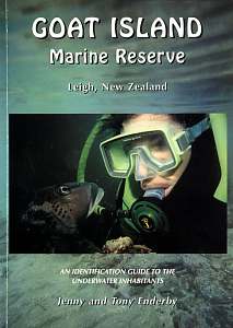 Jenny and Tony Enderby are avid divers and writers about the underwater
world. Living in Leigh, and frequenting the Goat Island Marine Reserve,
they have successfully documented and published an affordable booklet showing
what lives there. The species described range from fish to nudibranchs,
crabs to anemones and more. Priced at NZ$18.00, this A5 sized booklet is
a must for all who treasure our seas and who frequent the Goat Island Marine
Reserve.
Jenny and Tony Enderby are avid divers and writers about the underwater
world. Living in Leigh, and frequenting the Goat Island Marine Reserve,
they have successfully documented and published an affordable booklet showing
what lives there. The species described range from fish to nudibranchs,
crabs to anemones and more. Priced at NZ$18.00, this A5 sized booklet is
a must for all who treasure our seas and who frequent the Goat Island Marine
Reserve.
From the back cover: Tony and Jenny Enderby are natural history photojournalists who specialise in the underwater world. They live close to the Goat Island Marine reserve at Leigh and dive, snorkel and kayak the area regularly. During their 30 years combined SCUBA diving experience, they have dived many of New Zealand's best dive sites as well as overseas destinations. This booklet can be ordered from Seafriends, or from the authors, P O BOX 139; Leigh; 1240 New Zealand. The authors can be reached at enderby.t.j@xtra.co.nz. |
Books marked blue are available from the Seafriends Library.
Dept of Conservation: Leigh Reserve Complex, draft conservation management plan. Feb 1997.
Leigh Laboratory Publications
Marine Reserve Survey. (A M AYLING).1978.
Leigh Climate Report. 1991. J Evans. Bulletin #7.
Morton, John: Rocky shore ecology of the Leigh area. 1968.