GREATER MARINE PROTECTION FOR AUCKLANDS WILD WEST COAST Draft Proposal for Public Discussion and rebuttal by Dr
J Floor Anthoni
www.seafriends.org.nz/issues/war/westcoast.htm
This rebuttal of the draft proposal for
a West Coast sanctuary has been compiled in response to blatant inaccuracies
found with this document. The text in blue is provided by us whereas the
black text is that of the original document, unabridged. One unimportant
map was left out because it did not copy and one photo and one map have
been added.
Draft Proposal for Public Discussion Prepared by the Royal Forest and Bird Protection Society of New Zealand,
in consultation with the West Coast Working Group, March 2003
The funding for this project has been kindly provided by the New Zealand
Lottery Grants Board
.
'
Introduction The West Coast Working Group, in conjunction with the Royal Forest
and Bird Protection Society, is proposing an integrated marine management
plan for Aucklands West Coast. The plan will cover the area from South
Kaipara Head to Port Waikato, and will extend into the Manukau Harbour
as far as Big Muddy Creek (a line from Laingholm to Mako Point is the proposed
cut off).
Before preparing formal proposals we would like to ensure that the views
of the community and interested parties are canvassed. This special overview
and questionnaire is a chance for you to have your say.
Please complete and post the attached questionnaire (back page) by
Wednesday 30th April 2003 to: The closing
date is now 30 June 2003 Aucklands West Coast Project
Royal Forest and Bird Protection Society
PO Box 8138
Symonds Street
AUCKLAND
OR Fax (09) 303 3514
This special overview and questionnaire is also available online at
www.forestandbird.org.nz. www.forest-bird.org.nz/Marine/aucklandwestcoast.asp.
The Vision The outcomes of greater marine protection The vision for the west coast is a healthy coastal environment. The
environment should support all plants, animals, their associated habitats
and sustainable recreation activities. The integrated management approach
will break down the discontinuity between the land and the sea and will
instead view these ecosystems as one, interconnected. By protecting and
enhancing the natural values of this coast, human related values will also
benefit, creating a win-win situation.
Truly a noble vision but vague and flawed.
This statement envisions recreational fishing, which is sustainable, but
it excludes sustainable commercial fishing because this is not a recreational
activity. To claim that land and sea ecosystems are interconnected requires
justification. Very few creatures live in both domains. How human related
values benefit, and what a win-win situation means, must be qualified too.
We are interested to know.
The most notable discontinuity between land and
sea is in the knowledge that landlubbers have (of the land), compared with
that of seamen and fishermen (of the sea).
The largest problem with the integrated approach
is that it is designed to give control over large productive areas in the
sea to landlubbers and bureaucrats with little or no knowledge of
it. This proposal for instance, uses reasons for having terrestrial parks
for closing off large areas in the sea from fishing. It is a Trojan Horse
method with misleading arguments.
Scope of the Focus Area The integrated management plan for Aucklands West Coast encompasses
three Territorial Councils (Rodney District, Waitakere City and Franklin
District), and two Regional Councils (Auckland Regional Council and
Environment Waikato). Territorial councils cover the area above Mean High
Water Springs (MHWS) in conjunction with the Regional Councils. Regional
Councils cover the marine area from MHWS out to 12 nautical miles. The
proposed marine mammal sanctuary may cover
a wider area to include the current habitat of Mauis dolphin (formerly
known as the North Island Hectors dolphin).
Protection above and below the Mean High Water Springs The need for a land to sea approach The land bordering the Auckland west coast is under a variety of different
ownerships. Pockets of this land are protected as Regional Parks, Scientific
Reserve and QEII National Trust reserve land. Some of the land is under
private ownership such as the forestry lands leased by Carter Holt Harvey.
It is important that in any plan for marine management that we also include
the surrounding lands, as land management has a significant effect on our
marine environment. However, protection to date has in most places ended
above the Mean High Water Springs (MHWS).
A noble statement and a fresh approach.
However, most of the unwanted influence of this marine environment comes
from the large Waikato River catchment with its heavy load of sediment,
very rich in nutrients from human sewage, overfertilised dairy farms and
erosion. The other damaging influence comes from the city of Auckland with
its one million inhabitants. Most of their sewage ends up in this part
of the sea, after 'treatment', wiping out hardy species such as cockles
in the Manukau Harbour and toheroa outside. Sea currents in this area move
mainly northward, transporting the overnourished waters along the entire
coast. Waves and winds 'mop' these nutrients (now inside organisms) back
onto the coast. Thus the bad waters travel along the entire proposed park.
Scientists believe that over 80% of our indigenous
biodiversity is yet to be found in our oceans. In order to protect the
west coast a variety of management techniques are required both above and
below MHWS. This will help to create a continuum of protection from land
to sea.
Scientists are unlikely to find their
missing 80% in these waters, since they are degrading while already representing
a poor diversity. Our new marine finds come from the (clean) deep sea.
Aucklands Wild West Coast A unique marine environment that deserves greater protection Aucklands west coast marine environment is a very special part of
New Zealand. The great diversity in habitats found on this coast are a
result of its long geological history. Habitats such as the high coastal
cliffs, rocky coastline, iron sand beaches, dunes, and harbours are the
product of these past and continual processes. This variance in habitat
is the foundation for the areas equally diverse intertidal and subtidal
plants and animals.
Completely
wrong. This coast is characterised by a vast monotony of sandy flats bordered
by sandy beaches (85%) and a small shallow rocky shore (10%) with only
little biodiversity. In these waters, already unsuitable for cockles and
toheroa, coastal life is eking out a poor sustenance. The coast is dominated
by species-poor beaches (85%) of mostly heavy black iron sand. The mudflats
and mangroves occupy less than 5% of the coastline. Very few mangrove trees
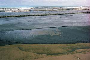
are found here. The picture on right shows a typical concentrated plankton
bloom near Muriwai, which feels and looks like an oil slick and causes
similar harm to burrowed clams and other life.
The west coast is a different biological province to Aucklands East Coast.
Waters are typically three degrees colder and nutrient rich, providing
nourishment for an array of marine life. Exposed rocky shores are host
to such organisms as green-lipped mussels, anemones, whelks and giant bull
kelp. Intertidal areas along the iron sand shores and dune environments
are the habitat of a great variety of bird life, some of which are endangered,
such as the NZ dotterel and the NZ fairy tern.
Subtidal areas are home to crayfish, numerous fin fish species and
a variety of marine mammals, such as whales and seals and the critically
endangered Mauis dolphin. Vegetation of the west coast is varied from
grasses such as spinifex and nationally rare pingao sedge to the large
native pohutukawa.
The areas greatly diverse ecology and landscapes are the reason for
an increasing number of tourists, both domestic and international, each
year. The west coast is popular among the public for its productive, recreational,
historical, geological and cultural values. The dramatic rock stacks, rich-black
iron sand and high-energy surf provide a great contrast to the regions
East Coast.
The Process For Protection Non statutory stage The proposed Integrated Marine Management Plan for Aucklands west
coast is currently at this stage. This is when we ask stakeholders and
the community what they think of each element of the proposal. The formal
application for each of the elements has not been made yet so the feedback
we receive will help us move to the next stages. The questionnaire at the
end of this document is your chance to have a say on the ideas presented
in this overview. Once the non-statutory consultation and public feedback
has been completed and considered, a formal application for each element
will be made.
Statutory stage The statutory process may differ slightly for each element of the integrated
marine management plan. However, in general the statutory process for all
formal applications will involve public notification and an opportunity
for public submissions.
Marine reserves: the formal application is notified publicly
and made available for the public to read and consider. Public have 2 months
from the time of notification to make a submission on the formal application.
Does this mean that marine reserves won't
go through a proposal process once the Park has been accepted? No consultation?
Why the hurry? This area has not been changing because of fishing. It has
been degrading because of poor water quality originating from far away.
Throw the Marine Reserves Act out. It is superfluous, clumsy and costly.
Do we really want to saddle our children with this burden?
Marine mammal sanctuary: the Minister of Conservation will notify
a marine mammal sanctuary application in the Gazette and the public will
have 1 month to make submissions.
The Marine Mammals Act should be abolished
and accommodated in the Fisheries Act. This allows for smoother management
of protected areas.
Marine Park: a marine park requires new legislation to be established
and may be progressed through a different
statutory process. An opportunity for public submissions would
still be allowed for.
No new legislation is required if the
whole park and all its closed areas are administered under the Fisheries
Act. This smoothly integrates with taiapure and mataitai reserves, and
fisheries regulations for Maui's dolphin, already protected under this
legislation.
Maori fishery management tools and conservation areas: formal applications
will be publicly notified and public submissions would be called for. The
Minister of Conservation and other relevant Ministers would consider the
formal applications and submissions that have been made when making their
decision. Each element of the plan will be progressed separately and at
different rates depending upon the legislative process and obligations.
Process Graph [left out, since it does
not provide new or necessary information. See DoC web site for this chart]
Why Look West? Aucklands West Coast has been chosen for a number of reasons
The worlds smallest and rarest dolphin is only found off this coast.
Mauis Dolphin has been recognised as a separate subspecies from other
Hectors Dolphin populations in New Zealand. It is believed that this special
population off Aucklands west coast is made up of less than 100 individuals,
which means that it is in a critical state. A marine mammal sanctuary would
give greater status to Mauis dolphin and help to further protect it from
habitat destruction, pollution and harmful fishing methods. The proposed
marine mammal sanctuary may cover an area
greater than just the Auckland west coast.
With great difficulty and under political
pressure has the northern Hectors dolphin been recognised as a separate
subspecies. Many geneticists disagree. A marine mammal sanctuary would
do no more for Maui's dolphin than the present fisheries restrictions.
Please explain what a greater status means to a dolphin.
The accessible rocky intertidal shores of the west coast are extremely
vulnerable to human harvesters stripping the rock platforms for food and
bait. This may become worse with an increase
in population and an enlarged multicultural sector within Auckland. Greater
marine protection may help to educate visitors
and conserve this marine life.
Of the rocky shore, a very small part
is accessible for harvesting. Most remains de-facto protected. Why shy
away from education? There are other ways to protect a spot.
Opportunities for educational experiences and scientific research will
be enhanced with greater marine protection on Aucklands west coast.
Bring in the clear water for education
and research. This coast is remote and accessible at only a few spots.
If reserves are needed here for education or research, be more specific
and be prepared to defend the proposals on their merits, and provide proof
of claims made. Why would you expect others to give their birth rights
away for something that will not work or for something that is not used?
Endangered bird life such as the New Zealand dotterel and the New Zealand
fairy tern can be found in the dune areas of this coast. Migratory waders
from international destinations such as Siberia and Alaska also travel
to this coast seasonally. A petrel colony exists at Bethells and a series
of gannet colonies at Muriwai.
Please be specific about how a Marine
Park up to MHWS will help the endangered birds? How are these threatened
by fishing? This amounts to misleading information.
Visitors to the Auckland west coast are increasing from both domestic
and international destinations. Located just 40 minutes from New Zealands
largest urban area, Auckland, the west coast is easily accessible. Greater
marine protection will help to enhance the west coast as a tourist destination
whilst ensuring its sustainability.
Please explain how tourism to this area
is negatively affected by fishing and how greater marine protection will
enhance it.
Adjacent land areas to the west coast have been recognised as regional
parks and reserves. Greater marine protection will create a continuum from
the land to the sea, creating a more holistic approach to environmental
management.
Please explain how this works and how
fishing affects a holistic approach. The continuum from land to sea has
repeatedly been overestimated. Water with mud flows to the sea. Fish fly
to the land in birds' stomachs. How does fishing affect this?
The Auckland west coast has rich cultural history. Maori archaeological
sites include canoe landing places, pa sites, look outs, burial grounds
and spiritual walkways. There are three iwi (Ngati Te Ata, Ngati Whatua
and Te Kawerau A Maki) from this coast who have spiritual ties with the
ocean and surrounding hinterlands. European culture is also evident along
the coast with historical sites including saw mills, cottages and railway
tracks.
Geologically the west coat is unique. Maori Bay has well preserved
pillow lava formations millions of years old and regionally significant.
As a result of past geological processes, the West Coast coastline and
foreshore includes a variety of habitats, Such as exposed rocky platforms,
high sea cliffs, offshore reefs, boulder beaches, mangrove areas, dune
fields, dune lakes and straight iron-sand beaches. Many of these areas
are regionally, nationally and internationally significant.
Explain how these are threatened and
how fishing affects these. The reality is that the coast here consists
of a monotounous muddy sand flat bordered by a shallow marine rocky shore,
poor in diversity. It is pounded by waves, while the sandy bottom is in
continuous upheaval.
The west coast is notorious for a long list of historic shipwrecks. In
1863 the Orpheus was wrecked on the Manukau bar on its way through the
Manukau Heads. 189 lives were lost making it New Zealands worst maritime
disaster.
It is quite annoying that so many arguments
above have nothing to do with the marine environment. All the above reasons
can be satisfied simply by . . . doing nothing.
Discover the Values of Aucklands West Coast
Recreation: Surf lifesaving, surfing, fishing, swimming, beach
walking, picnicking are just some of the popular recreation activities
on the Aucklands West coast. There are a number of Surf Life Saving Clubs
along the beaches from Muriwai Beach in the north to Karioitahi Beach in
the South.
Intertidal and subtidal marine life: The biota of the west coast
is rich and diverse. Intertidal organisms such as green-lipped mussels,
paua, anemones and whelks can be found. Crayfish, gurnard, trevally, snapper,
whales and dolphins are all present offshore.
Fishing: Commercial and recreational fishing are popular on the
West coast. Rough seas often make this dangerous and many places inaccessible.
Species such as snapper, trevally and gurnard are caught regularly.
Right. The inaccessibility of this coast
gives it de-facto protection. Snapper, trevally and gurnard are migratory
species, not particularly bound to a particular place. They venture in
and out of the degraded coastal zone where they are occasionally caught.
The recorded recreational catches are but a very small part of the fish
stocks over the continental shelf. It can be said that recreational fishing
on the west coast does not materially affect the fish stocks there. The
fin fish taken for food by the public are all managed under the QMS, which
will continue with or without a marine park or marine reserve network.
These protection measures will not affect the state of those fin fish
stocks.
Maori culture: There are three iwi along this coast: Ngati Te Ata,
Ngati Whatua, and Te Kawerau A Maki. The Maori have many spiritual ties
to this coast. Some of the archaeological sites found in the area include
canoe landing places, burial sites and spiritual pathways.
Great habitat diversity: The Waitakere Ranges has a rocky coastline,
exposed on its west to the Tasman Sea. The coastline consists of a variety
of exposed offshore reefs, rock platforms and sheltered crevices. This
great diversity in habitat within such a small area has resulted in an
equally diverse biota. Habitat on this coast also includes two sandy beach
intertidal areas on either side of the Waitakere Ranges (South Kaipara
Peninsula and the Awhitu Peninsula.
Wrong, see above.
Fascinating geology: Geologically the Auckland west coast is phenomenal.
Dune barriers, pillow lavas, volcanic necks (such as Lion Rock at Piha),
rocky and sandy coastal shores have all been created as a result of geological
processes. Many of these landscapes are recognised as regionally, nationally
and internationally significant.
Historic shipwrecks: The Auckland west coast has a long history
of shipwrecks due to its often heavy seas. In particular the heads of the
Manukau and Kaipara Harbours are notorious for such disasters. In 1863
the Orpheus was wrecked on its way in to the Manukau Harbour. 189 lives
were lost making it New Zealands worst maritime disaster.
Mauis dolphin: Mauis dolphin (formerly known as the North Island
Hectors dolphin) is critically endangered with less than 100 individuals
remaining. The greatest number of sightings for the dolphin is along the
Awhitu Peninsula and at the Manukau Harbour Heads.
Birdlife: The South Kaipara Head is an extremely important breeding,
roosting and feeding ground for a variety of birds. Threatened species
endemic to New Zealand, such as the NZ dotterel and the NZ fairy tern use
the dune area to nest and the foreshore to feed. This area is also important
internationally as a stopover for migratory birds coming from as a far
afield as Alaska and Siberia. Birdlife is also significant on the sandspit
at the mouth of the Waikato River where NZ dotterels are also reportedly
breeding.
Outstanding productive habitat: Big Muddy Creek inside the Manukau
Harbour has an outstanding representative growth of mangrove forest. The
intertidal mudflats associated with the mangroves are rich in intertidal
organisms.
Mangroves are indeed doing well in all
the mud from soil degradation.
Rare and endangered plants: Whatipu Sands Scientific Reserve has
some of the last naturally growing Pingao sedge plants. These rare native
sandbinding plants help to prevent sand from eroding.
Native pingao is not rare but it is threatened
by harmful dune plantings by dune huggers. It needs open rolling dunes
to thrive. The attentive reader will by now have noticed that an organisation
like Forest and Bird can find no valid arguments for their proposal. They
are not aware of the very poor quality of the coastal water here, or they
deliberately wish to keep readers in the dark about this. Like generals
without armies, they draw lines on maps and move their pieces. Can we really
be serious about their proposal?
Threats to the Natural Values of Aucklands West
Coast Commercial and recreational fishing methods using set nets and commercial
trawling: This is of particular threat to Mauis dolphin. The dolphin
has lungs similar to humans and so when caught in a set net may drown if
unable to break free. Given the critical state of this dolphins population
(less than 100), fishing related threats need to be reduced to zero to
ensure its survival. Six dolphins died in 2001-2002 due to set nets.
This threat has been adequately dealt
with using fisheries regulation. A marine park won't do better. If set
nets are bad, ban them. It is as simple as that. If a population cannot
survive a few unnatural deaths, there must be something else wrong - pollution
comes to mind.
Over fishing in our subtidal areas: The mixture of commercial fishing
quotas and recreational fishing catches means that a great variety and
number of fish species are being taken from the west coast every year.
Increases in Aucklands population will mean an increase in recreational
fishers. The extinction of any species from our marine environment may
have further repercussions throughout the entire ecosystem.
Marine populations have for thousands
of years done well with human exploitation. Furthermore, the West Coast
is naturally protected by high waves. It is not readily accessible over
large parts of its rocky shore. Its beaches are extensive. Recreational
fish catches here are a negligible part of the total. Extinction in the
ocean has not been observed for any water-breathing marine species yet,
worldwide. In NZ there exists no indication either.
Pollution: The main source of pollution is from poor land management
in surrounding lands. Pollution can affect
water quality and eventually accumulate enough to destroy some habitats
and species. There is growing evidence to suggest that dioxins may
affect fertility in Mauis dolphin. These dolphins are at a greater risk
to pollution due to their preference for shallow waters. Pollution sources
may
include sediment run -off, litter on beaches, fertiliser runoff, sewage
disposal, etc.
The main threat is pollution arriving
from farmland far away in the Waikato and further. Carried by currents,
pollution arrives from as far away as New Plymouth. Pollution also arrives
in large volumes from Auckland's sewage plants. Very little pollution arrives
from the sandy dunes along this stretch of ocean. So what does F&B
suggest we do about this, the real problem? What about a truly integrated
approach and begin saving the land? Why does F&B believe
that this is not the main reason for stress in Maui's dolphin? Compared
to the observable stresses from pollution, dioxins are far-fetched and
unproven.
Visitor impacts: These may be numerous and key elements of each
of the other threats mentioned here. Increases in people fishing, walking
on rock platforms and leaving litter on beaches are just a few of the potential
threats if visitor numbers are not carefully monitored and managed.
Would education not be a better tool?
But where is the proof? What specific monitoring and management
tools are envisaged?
Intertidal over-harvesting: Shellfish over-harvesting is an increasing
problem on many of the intertidal rock platforms on west coast beaches.
As the Auckland population grows and becomes more multicultural, an increasing
number and variety of organisms are being stripped from our rock platforms.
This may have significant effects throughout
the entire marine food chain.
Yes, this is a real issue. However, we
would emphasise that the management to date of the intertidal zone can
only be described as pathetic. The regulatory framework and the enforcement
of same are simply not working. Something needs to be done and done decisevily.
There has to be a better way marine reserves are certainly not the answer
but some simple tools when well publiscised well, can work.
By all means, close off areas of the shoreline
to harvesting. Obviously we need to be able to close areas for whatever
time is required for the recovery of species. However, it is fair to say
that the exploited areas are a small part of the whole, which is protected
by poor access. There is no evidence that by stripping the intertidal area,
the effect ripples down to the subtidal areas, let alone to the entire
food chain. There exists no ecological evidence either.
Uncontrolled domestic animals: Domestic animals such as cats and
dogs that are allowed to roam free may pose
a threat to wildlife. Animals such as Little Blue Penguins found on the
west coast are often harmed by domestic animals.
When are the local territorial authorities
going to start enforcing their bylaws? Marine reserves won't help.
Marine invaders: Marine pests are a significant threat to native
wildlife. Pests compete with the natural wildlife for habitat and food,
eventually taking over and eliminating natural species. Currently there
are just four definite intertidal marine invaders on Aucklands west coast.
This is in contrast to some 66 found on the East Coast. This great difference
in numbers is due to the many cargo ships and tourists on leisure boats,
which frequent the East Coast. For this reason, among others it is extremely
important that we ensure the west coast remains invader free.
We would like to know how a marine park
or a marine reserve is going to prevent infestation from marine pests.
The main reason is not that fewer ships visit this area but that the 60
pests on the other side choose not to live here due to degraded conditions.
What have these 60 pests done to the marine environment? What is their
significant threat to native wildlife?
Land pests: Introduced pests such as stoats and wild ginger can
cause harm to native wildlife. Greater biosecurity practices may
help to prevent such pests from establishing on the west coast.
The situation in the sea is entirely
different from that on islands where introduced pests are profoundly damaging.
How are protected areas going to help? What kind of biosecurity practices
will be effective? Have any worked so far?
Off-road vehicles: Off-road vehicles can
pose significant threats to our wildlife. Sensitive areas above mean high
water springs such as Papakanui Spit, where endangered native birdlife
is found, should be off limits to such vehicles. Both Muriwai and Karioitahi
beaches see considerable beach traffic and any movement of these vehicles
into dune areas is of concern.
If there is a problem, put up a sign.
Make Papakanui Spit a bird sanctuary. Fishermen will give it their blessing.
But first prove the irreversible damage caused by vehicles. A Marine Park
to MHWS will have no impact on this area.
Hot Spots Areas that may warrant greater protection as marine reserves, rahui,
maitaitai and/or taiapure areas. The
areas outlined above have been chosen for their biological values, their
ability to represent the range of natural habitats occuring on the Auckland
West Coast and their ability to provide educational opportunities.
1 Waionui Inlet and Papakanui Spit: The Inlet is an important
feeding area for a variety of birdlife. It is also important as a breeding
area for adult fish and a safe haven for juvenile fish. The inlet is extremely
productive and adds to the total productivity of the Kaipara Harbour, which
is a popular fishing spot. Papakanui Spit (stewardship area) forms the
western boundary of Waionui Inlet and is a vitally important breeding and
roosting site.
Make it a bird sanctuary. Why has this
not been done already if it is so important? You have fishermen's blessing
and support.
2 Oaia Island and Muriwai Beach: Oaia Island is situated approximately
1.5km off Muriwai Beach. It is a haul out site for the New Zealand fur
seal with numbers increasing annually. The island is also home to a series
of Australasian Gannet colonies, one of 3 sites within the area. Muriwai
beach is a representative stretch of exposed sandy coastline supporting
a typical range of bivalves, which live deep below the sand at extreme
low water springs. A small part of Muriwai beach (southern end) is a Telecom
cable area where fishing and anchoring is prohibited.
Offshore from Oaia Island and Muriwai Beach there are a great variety of
fish species such as gurnard, trevally, and snapper. Whales, dolphins and
other marine mammals are also found off this coast.
The wildlife shows that fishing by them
and people can go together, but don't be surprised when a burgeoning seal
population depopulates the area. Are they breeding there and if not, why
not? Make the Telecom cable area a marine reserve, but don't expect it
to work. Show it on the map. You have fishermen's support. Where the sea
becomes clearer, outside the management area, there is indeed an abundance
of fish. Unfortunately, the recreational fisher cannot get there. The bivalves
are a more sorry story, since toheroa, once abundant here, went in decline
and had to be protected from harvesting, using fisheries regulation in
the late 1970s. It is not expected to be available for widespread harvesting
in the foreseeable future with stocks teetering at 2% of what once was.
Polluted water is their enemy. What difference would a marine reserve make?
3 Maori Bay Coast: Day visits to this part of the Waitakere coastline
are popular. Attractions include the gannet colonies, fishing, pillow lava
formations, intertidal life and surfing. The area is very accessible and
camps and surf lifesaving clubs are close by for educational groups to
base themselves.
4 Te Waharoa Coast: This area is characterised by habitats, including
rocky shores, offshore reefs and gravel and sand beaches. The great variety
in habitats has created an equally diverse intertidal life - the most diverse
along the entire Waitakere coastline.
5 Anawhata Coast: Habitats within this area include sandy beach,
rocky shores and boulder beaches. Seaweed and sponges are particularly
diverse, along with a variety of other intertidal life. The area has not
yet been spoilt by subdivision and hence has an aesthetically pleasing
landscape.
6 Piha Coast: This is the most popular beach on the Auckland
west coast and is very accessible. Consequently, much of the intertidal
life has been stripped. Locals have a voluntary ban in place on the taking
of shellfish. This would be given legal strength if it were to be made
into a marine reserve. There are also a number of camps and surf clubs
within this area, making it an excellent base for educational groups.
If legal strength is needed, the Fisheries
Act would be the better agent. Let locals get their act together and manage
the stocks. If a voluntary ban works, why make it more complicated? If
it doesn't work, why would regulation help?
7 Destruction Gully Coast: Habitat within this area consists mostly
of hard volcanic rocky shores and boulder beaches. Nineteen intertidal
species are found only in this area. Colourful sea slugs can be found here
as well as a diverse range of subtidal animals.
Are these species in any way affected
by fishing? The fact that such species are found only here is because hard
rock is rare along the West Coast. Most rock is too soft to secure sessile
organisms long enough to grow old. Where hard rock is found, long-lived
species can be expected, complete with the life depending on it like colourful
seaslugs. This area is just too smal to be of any ecological importance.
It shows how species-poor the rest of the area is.
8 Lawry Point Coast and Big Muddy Creek: Habitat in this area consists
of intertidal mudflats, sandstone reefs, stable cobbles and mangrove forest.
Colourful sea slugs, shelly tube worms and a rich assemblage of sea squirts
can
be found here. The educational camp at nearby Armour Bay could
make an excellent base for studies.
This area is favourably affected by rapid
tidal currents which cleanse the substrate and organisms infested with
mud. Its only threat is from the rich sewage effluent and dense plankton
blooms. This in turn is beneficial for a variety of opportunistic organisms
like seasquirts, often indicators of degradation. The area is not under
any form of threat, and if it were needed for education, this would have
been done a long time ago. The fact that it is not being used as such,
probably means that it is not an excellent base for studies.
9 Port Waikato estuary: Located at the mouth of the Waikato River,
the Port Waikato estuary is an important feeding and breeding area for
New Zealand wildlife. The Waikato River is the longest river in New Zealand
and is the habitat for a variety of native freshwater fish such as yellow-eyed
mullet, black flounder, and longfinned eels as well as saltwater fish such
as Kahawai. Most of New Zealands native freshwater fish are migratory
and need access to the sea or an estuary during their lifecycle. This is
one important reason for the protection of this estuary. The estuary is
also an important feeding area for a number of wading birds. Nearby at
the mouth of the river is a sand island, which is prime breeding habitat
for regionally important bird species such as the Caspian Tern and NZ Dotterel.
Man and Beast have been doing well together
in this area. Leave it alone. What benefit could a reserve possibly have
for migrating species such as mentioned above. For fish the Waikato River
is only as long as it takes to reach the first dam. If the birds need protecting,
then create bird sanctuaries, but provide proof first. New Zealanders have
the right to see such proof before surrendering their birth rights.
Note: Ngati Whatua have stated that they would like to see Hot Spots
1&3 protected by taiapure.
The Integrated Management Plan The integrated marine management plan for Aucklands West coast
is made up of 5 main elements (A - E on following pages), including a marine
park, marine mammal sanctuary, marine reserve network, Maori fishery management
tools and shoreline and hinterland conservation areas.
A. Marine Park: The integrated concept for the west coast is
to establish a marine park with a number of different zones within it.
The establishment of a marine park will require special legislation. This
may be a timely process and hence other elements making up the park such
as a marine reserve network and a marine mammal sanctuary may
be progressed separately. Legislation already exists to develop these latter
elements. Examples of Marine Parks in New Zealand include the Hauraki Gulf
Marine Park and the Sugar Loaf Islands Marine Park. International examples
include the Greater Barrier Reef Marine Park, Australia and Solitary Islands
Marine Park, Australia.
All this can be done under the Fisheries
Act. No extra legislation is needed. Every option a marine park wishes
to have is already provided for within the Fisheries Act. The accompanying
Discussion Document reveals the plan to have all commercial fishing banned
from Marine Parks by a change to the Fishing Act. This change will at the
same time ban all commercial fishing in the Hauraki Gulf Marine Park. Beware
of the Trojan Horse!
Why a Marine Park? The West Coast Working Group along with many
local residents and community members believe
that a Marine Park is needed on the Auckland West coast to better coordinate
the management of the marine environment and foreshore. The objective of
the marine park would be to protect representative
examples of marine bio-diversity, while catering for a range of recreational
activities. A Marine Park would establish
an advisory/management board made up of a number of representatives from
stakeholder and community groups. The responsibilities of this board would
include advocacy, education and the co-ordination of management objectives
within the marine park area. A marine park advisory board may
achieve greater marine management by working alongside local bodies and
statutory authorities. In theory the Marine
Park may be thought of as a legislative tool
box in which all other legislation is used and monitored.
The word believe is indeed well
chosen, since nothing in this proposal is based on good knowledge. The
marine park would do absolutely nothing to marine biodiversity,
which is about sustainable populations of all species, and these are not
threatened by current fishing practices. Local management is indeed needed
where areas become protected, but with the maintenance budget that goes
with it. This is not possible under the MRA. The proposed management board
consists of bureacrats rather than the locals.
What you can do in a Marine Park: A Marine Park would have a number
of different zones within it. Some of these zones may
allow for marine reserves whilst others will allow for recreational fishing.
Activities that may be enjoyed in a Marine Park include:
Coastal walks
Picnics
Recreational line fishing and drag netting (primarily for mullet
and flounder at Muriwai and Karioitahi beaches) within the general amateur
fishing regulations or specific, local restrictions as may apply
Surfing
Swimming
Rock pool observation and nature study activities
Bird watching
Boating and sailing
Underwater diving (with local restrictions)
A marine park is not needed for all this.
What you cannot do in a Marine Park: Activities that may
be prohibited in the marine park include:
Commercial fishing
Recreational set netting
The discharge of wastes
Construction of any structure unless specifically approved
Dredging
Inappropriate use of a vessel
Fishermen are most interested to know
what the final outcome is going to be. Here the word may is used.
What does that mean in practice? Not mentioned here, the accompanying
Discussion Document wants to modify the Fisheries Act to ban all commercial
fishing inside a Marine Park. Since the Continental Shelf boundary runs
from 8nm out in the north to 14nm in the south, the proposal implies a
total commercial fishery exclusion over the width of the continental shelf.
Option 2b takes 400x22= 8800km2 or 880,000ha out of fishing, without
any suggestion of compensation or how much this will cost New Zealanders.
This is 5% of NZ's territorial sea! Compare this with 5km2 for Goat Island
and 7480km2 for the Kermadec Islands. How can the people who work with
the sea on a day to day basis have any confidence in rules made by people
who do not? Think about it. Think about its social effects. All sacrifice
for no benefits in return.
B. Marine Mammal Sanctuary: The Department of Conservation administers
the Marine Mammals Protection Act 1978, which provides for the conservation,
protection and management of marine mammals. This Act allows for the establishment
of marine mammal sanctuaries. Activities can be controlled by specifying
what can and cannot be undertaken within the sanctuary and by imposing
restrictions. Examples of marine mammal sanctuaries within New Zealand
include the Banks Peninsula marine mammal sanctuary (to protect Hectors
dolphin) and the Auckland Islands marine mammal sanctuary (to protect
New Zealand sea lion and southern right whale).
The Marine Mammals Protection Act is
one of this country's big mistakes, since all it does is already provided
for in the Fiseries Act. It is an unnecessary and costly duplication that
should be done away with. Maui's dolphin is now protected under the Fisheries
Act, not under the MMPA.
Why a Marine Mammal Sanctuary? The worlds smallest and rarest marine
dolphin is only found off this coast. Mauis dolphin has been recognised
as a separate subspecies from other Hectors dolphin populations in New
Zealand. This special population off Aucklands west coast is made up of
less than 100 individuals, which means that it is in a critical state.
A marine mammal sanctuary would give greater
status to Mauis dolphin and help to further protect it from habitat destruction,
pollution and harmful fishing methods. Increasingly, New Zealand fur seals
are also being seen off this coast. Fur seals would
also benefit from greater protection on this coast.
Under political and ideological pressure
to give it higher conservation status, the Maui's dolphin has been recognised
as a separate subspecies. The scientific argument is based on only very
few Maui's dolphins in the samples used. The same data suggests that the
East and West Coasts of the South Island also consist of two different
subspecies. A population of 100 is indeed in a critical state, but the
reasons for this have never been adequately presented. In the end, we must
accept that extinction is a natural selection process, however sad. But
the point is that all the protection it can be given, has already been
provided for. A sanctuary is not needed and would not achieve more. What
would greater status mean to a dolphin? As far as the fur seals
go, we must expect them to multiply in time, also threatening Maui's dolphin
by competing for their food. Who would like to protect that?
Marine mammal scientist
Steve Dawson retorts (19 Nov 2004) for the complete letter see say/opinion.htm You need to read and understand
the genetic work. In its mt-DNA, the NI population is more different to
either of the South Island east and west coast populations than the latter
two are from each other. Further, the NI ones are noticeably bigger (about
10% in adults). These changes are not trivial. You say that the analysis
is based on just a few samples. Well, that's not surprising, there are
just a few of these dolphins left.
To my knowledge there was
no political drive behind the analysis. To say that there was is an unfair
slur on the folks doing the work.
Floor
Anthoni replies (19 Nov 2004)
You
try to be pedantic about knowing when a subspecies is a subspecies and
when it is not. In biology, this is still a contentious area, but I have
explained your point in the Hector's Dolphin article, and warned readers
here of the amount of contention and arbitrariness and the small sample
size, which you agree with. You say that the differences are not trivial
- a matter of opininon. In any case they are irrelevant to the survival
of the species.
What you can do in a Marine Mammal Sanctuary: Activities that may
be enjoyed in a marine mammal sanctuary include:
Coastal walks
Picnics
Recreational line fishing and drag netting (primarily for mullet
and flounder at Muriwai and Karioitahi beaches) within the general amateur
fishing regulations or specific local restrictions as may apply.
Surfing
Swimming
Rock pool observation and nature study activities
Bird watching
Boating and sailing
Underwater diving (with restrictions)
Big Deal!
What you cannot do in a Marine Mammal Sanctuary: Activities that
may
be prohibited within a marine mammal sanctuary include:
Commercial fishing
The discharge of wastes
Inappropriate use of vessels
C. Marine Reserve Network Marine reserves may be set up under the
Marine Reserves Act 1971 and are administered by the Department of Conservation.
Marine reserves protect areas of the sea, seabed and foreshore in a natural
state for the purpose of scientific study.
Marine habitats, plants and animals are all protected within marine reserves.
These areas are usually completely no-take. Examples of marine reserves
in New Zealand include Cape RodneyOkakari Point Marine Reserve (also known
as Goat Island), Long BayOkura Marine Reserve and Kermadec Islands Marine
Reserve.
Why a Marine Reserve Network? The intertidal organisms of many
of the more accessible places on the Auckland west coast have been, and
continue to be over-harvested. Subtidally, fish are taken by recreational
and commercial fishing. Scientists believe
that 80% of New Zealands bio-diversity remains undiscovered in our oceans.
For these reasons it is important that we create safe havens or refuges
for our marine life. Studies from around the world of 100 no-take marine
reserves have shown an average increase of 91% in the number of fish, 31%
increase in the size of fish and 23% increase in the number of species
within reserves. Spillover of fish may occur
into the surrounding waters of marine reserves. Having a network of no-take
areas on the Auckland west coast will ensure that a representative collection
of marine bio-diversity is protected on this coast and will add to the
protection of New Zealands bio-diversity as a whole. They also allow for
scientific research to be undertaken in the marine environment. Currently
there are no marine reserves on the Auckland west coast.
This paragraph gives a large amount of
misleading information. It is unbelievable how gullible the marine reserves
lobby is. Let's count them for fun: 1) Whereas the more accessible places
are overharvested, the much larger parts of the intertidal rocky shore
remain de-facto protected. 2) You cannot take fish above the high tide.
3) Scientists will NOT find new species in this degraded area. Almost all
new discoveries come from the clean deep sea. 4) These studies have mostly
been done on heavily overharvested tropical coral reefs, which bear little
or no relevance to the NZ situation. The benefits claimed are not impressive,
and not worth sacrificing so much for. 5) The best spillover that can be
expected is no more than 10% of the lost fishery. It can be expected only
for resident fish, which are rare on this coast, and are not typically
fished. 6) The network idea lives only in people's minds. It has never
been substantiated. 7) Networks of marine reserves bring large areas under
control of people who have no knowledge or experience of the sea. It is
an undesirable situation. 8) Scientific research can and should be done
anywhere, and should not depend on or wait for the presence of a marine
reserve. 9) The Telecom cable area is a de-facto marine reserve, but scientists
have never looked there.
What you can do in a Marine Reserve: Marine reserves are open for
the public to enjoy and study the marine environment. Activities that do
not damage or disturb the marine life are allowed in marine reserves. Some
of the activities enjoyed in marine reserves include:
Boating
Anchoring There is a fine of $5000 for uprooting
a marine plant in the proposed Bill.
Picnicking
Swimming
Snorkelling
Diving
Nature studies
Surfing
What you cannot do in a Marine Reserve: Generally, activities
that damage or disturb the habitat and marine species are not allowed within
Marine reserves. Commercial fishing is not allowed and usually recreational
fishing and seafood gathering is not allowed either.
NB: The Marine Reserves Act is currently being revised by Parliament.
What
a waste of time - it should be abolished.
D. Maori Fishery Management Tools
Taiapure: A taiapure is an estuarine or littoral coastal area,
which is traditionally important to iwi or hapu. A taiapure protects these
local areas and recognises that local communities have special needs relating
to them.
Anyone may apply for a taiapure. The proposal must show that the area
is important to the local iwi or hapu for kaimoana (seafood), or spiritual
or cultural reasons. The Minister of Fisheries
receives taiapure applications and makes his/her decision in consultation
with the Minister of Maori Affairs. A special tribunal of the Maori land
court hears any submissions or objections. If the Ministers declare that
the area should become a taiapure, the Minister of
Fisheries forms a management committee of people nominated by and
representative of the local Maori community. The committee recommends regulations
to the Minister of Fisheries to manage the area. The Ministry works with
the committee to administer these regulations. Commercial and/or recreational
fishing may be allowed in a taiapure however, rahui may be applied to stop
all or some fishing to allow restoration of these coastal fisheries or
because the area is sacred to iwi or hapu.
Maitaitai: A maitaitai reserve is an area of traditional importance
to Maori where the tangata whenua are authorised by the Ministry
of Fisheries to manage and control the harvest of seafood for non-commercial
purposes. Kaitiaki appointed by the local Maori community can manage this
area by passing bylaws.
Bylaws may include species that can be taken, quantity of each species,
size limits, methods of catch, area where taken and any other specifications
made by the kaitiaki necessary for the sustainable management of fisheries
resources.
Controls on non-commercial fishing must apply equally to all people
with only one exception. If a reserve is closed for general harvesting,
the kaitiaki may approve the taking of seafood to meet the needs of the
marae belonging to tangata whenua of the reserve only.
Rahui: Rahui is a ban on all or some fishing to allow restoration
of coastal fisheries or because the area is sacred to iwi or hapu. Rahui
may be applied to selected species and may only be initiated by tangata
whenua. Rahui may be applied within a taiapure or maitaitai reserve.
The statutory support for a rahui comes from the Fisheries Amendment
Act 1998, and is part of the Fisheries Act 1996 (the principal Act), section
186a. This amended section allows for temporary closures of fishing areas
or restrictions on fishing methods (maximum of two years after notification
in the Gazette). Section 297 and 298 under Part 16 of the Fisheries Act
1996 allows for regulatory closures, which are open ended. Currently the
longterm rahui at Karekare beach on Aucklands west coast is supported
by a regulatory closure.
Every local community should have the
right to call for and manage a local area. The racial clauses in all acts
should be abolished. We are one people, in one country, having but one
future. More importantly, the above arguments once again demonstrate that
the Fisheries Act is the more flexible agent for creating, managing and
policing protected areas, both in the territorial seas and the Exlusive
Economic Zone.
E. Shoreline and Hinterland Conservation Areas
The surrounding shoreline and hinterland areas of the West coast require
protection as well as the marine area below MHWS if we are to achieve a
holistic land to sea approach to environmental management.
Through the integrated management plan for the Auckland west coast private
landowners will be invited to consider including
part of their land as private conservation areas. Liaison with local and
regional authorities to further protect public land will also be undertaken.
Conservation areas may be established under the QEII National Trust or
other covenant. Local and regional authorities may apply for reserve status
for lands also under the Reserves Act 1977. For example the Whatipu sands
area has recently been made into a scientific reserve by the Department
of Conservation and will be administered by the Auckland Regional Council.
Integrated Management Plan Boundary Options
Boundary Options (1 & 2) Each boundary option is made up of exactly the same elements as outlined
in points A - E of the Integrated Management Plan. The only difference
between the two models is the size of the marine park and the size of the
marine mammal sanctuary. The West Coast Working Group and Forest and Bird
are seeking your comments on the entire concept of the integrated plan
with each of the elements and also your preference for the different boundaries
of the marine park and marine mammal sanctuary. See maps above.
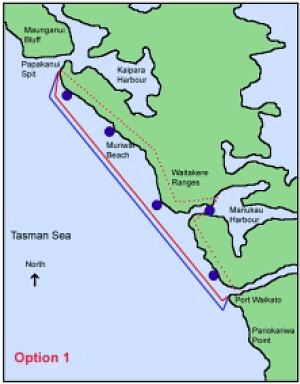
Option
1 Marine Park from Papakanui Spit in the North to Port Waikato in the
South. Extends into the Manukau Harbour to a line drawn from Laingholm
to Mako Point. Extends from Mean High Water Springs (MHWS) to 4nm seaward.
Marine Mammal Sanctuary from Papakanui Spit in the North to Port
Waikato in the South. Extends from MHWS to 4nm seaward. Extension into
Manukau Harbour the same as the Marine Park boundary.
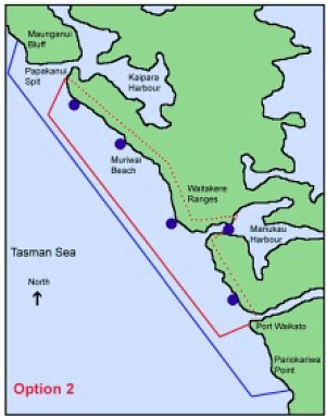
Option 2a (with 4nm marine mammal sanctuary)
Marine Park from Papakanui Spit in the North to Port Waikato in the
South. Extends into the Manukau Harbour to a line drawn from Laingholm
to Mako Point. Extends from Mean High Water Springs (MHWS) to 12nm seaward.
Marine Mammal Sanctuary from Maunganui Bluff in the North to Pariokariwa
Point. Extends from MHWS to 4nm seaward. Extension into Manukau Harbour
the same as the Marine Park boundary. This entire area covers the current
Ministry of Fisheries commercial set net ban area).
Option 2b (with 12nm marine mammal sanctuary)
Marine Park from Papakanui Spit in the North to Port Waikato in the
South. Extends into the Manukau Harbour to a line drawn from Laingholm
to Mako Point. Extends from Mean High Water Springs (MHWS) to 4nm seaward.
Marine Mammal Sanctuary from Maunganui Bluff in the North to Pariokariwa
Point. Extends from MHWS to 12nm seaward. Extension into Manukau Harbour
the same as the Marine Park boundary.
This is one of the most misleading parts
of this proposal. Can you read the 'NB maps not to scale' remark in the
graph legends above? Well, these maps do indeed not truly represent the
plan. Deliberate deception comes to mind. For instance, Maunganui Bluff
lies 40 nautical miles off the map to the north while Pariokariwa Point
lies 80 nm off the map going south. We have provided a map in the righthand
margin which more truly reflects the situation. For comparison, the Goat
Island marine reserve (5.2km2) has been shown to scale in brown. Also left
out was the large de-facto marine reserve, the no-anchoring, no-fishing
cable zone, shown on our map in orange. It extends from the shore to the
territorial limit, 12nm out in sea, covering an area of nearly 100 square
nautical miles (over 320km2) or twice the total area already in coastal
marine reserves.
After having read this rebuttal, would you have
any confidence left in what Forest and Bird say, or the Department of Conservation
for that matter? Would you have any confidence in them managing these areas?
 Completely
wrong. This coast is characterised by a vast monotony of sandy flats bordered
by sandy beaches (85%) and a small shallow rocky shore (10%) with only
little biodiversity. In these waters, already unsuitable for cockles and
toheroa, coastal life is eking out a poor sustenance. The coast is dominated
by species-poor beaches (85%) of mostly heavy black iron sand. The mudflats
and mangroves occupy less than 5% of the coastline. Very few mangrove trees
are found here. The picture on right shows a typical concentrated plankton
bloom near Muriwai, which feels and looks like an oil slick and causes
similar harm to burrowed clams and other life.
Completely
wrong. This coast is characterised by a vast monotony of sandy flats bordered
by sandy beaches (85%) and a small shallow rocky shore (10%) with only
little biodiversity. In these waters, already unsuitable for cockles and
toheroa, coastal life is eking out a poor sustenance. The coast is dominated
by species-poor beaches (85%) of mostly heavy black iron sand. The mudflats
and mangroves occupy less than 5% of the coastline. Very few mangrove trees
are found here. The picture on right shows a typical concentrated plankton
bloom near Muriwai, which feels and looks like an oil slick and causes
similar harm to burrowed clams and other life.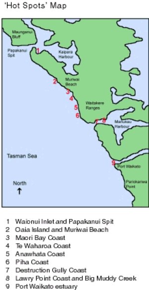 The
areas outlined above have been chosen for their biological values, their
ability to represent the range of natural habitats occuring on the Auckland
West Coast and their ability to provide educational opportunities.
The
areas outlined above have been chosen for their biological values, their
ability to represent the range of natural habitats occuring on the Auckland
West Coast and their ability to provide educational opportunities.
 Option
1
Option
1