Mimiwhangata Marine Reserve Proposal Community Discussion Document, introduction
Department of Conservation - Te Papa Atawhai
The Department of Conservation and the Kaumatua of Te Uri O Hikihiki
are proposing to create a Marine Reserve at Mimiwhangata. Mimiwhangata
peninsula is located on the east coast of Northland, north of Whangarei,
and is one of the most beautiful stretches of the Northland coastline.
It is currently designated as a Marine Park and is valued for spectacular
scenery, wildlife and cultural heritage. The sea once teemed with life,
including tuatua, kina, scallops, crayfish, mussels and numerous species
of fish. In the last 30 years, biologists have been surveying the Mimiwhangata
area and recorded more than 70 species of fish.
Damaged beauty or potential paradise? Recent studies (from 2001 to 2004) indicate no real recovery of species
abundance since the surveys of the 1970s and 1980s, and include some notable
declines in abundance of certain species. The numbers of tuatua and oysters
are greatly reduced in the Marine Park. Packhorse crayfish are now uncommon
with no large individuals seen in recent surveys. Red crayfish numbers
have stagnated with few large animals.
Despite the Marine Park being introduced in a bid to protect and restore
the Mimiwhangata marine environment, fish abundance has not improved since
the mid-1970s surveys.
The whole purpose of this marine park
was not to optimise the environment but the pleasure one gets from gathering
one's own seafood while being in a beautiful area. Management of the park
has been very slack, as witnessed by the lack of appropriate signs at boat
ramps. Many people who fish here, are not aware of regulations. With proper
local management, the existing rules could have been tightened to achieve
a higher degree of protection.
How did this happen? There are a number of possible reasons why the Marine Park concept
has not delivered positive results at Mimiwhangata. Marine Park rules allow
selective recreational fishing and shellfish gathering. It is possible
that as the area became easier to get to, with improved road access and
increased boating activities, growing pressures on fish stocks and shellfish
numbers have taken their toll.
There exists no doubt that access to
the sea has become more common-place, and this can be controlled. But because
of its remoteness and exposure, fishing pressure in this area is rather
low. However, Mimiwhangata has also suffered from immense degradation as
the water's quality impoverished. But why are we discovering only today
that there's less fish than anticipated?
Mimiwhangata can be fixed It is possible with community and iwi support to re-create some of
the magic it held in the old days. When
given time and total protection, the seas natural processes can work to
replenish damaged marine environments and depleted species. The most effective
way to regenerate Mimiwhangata is to set up a fully protected Marine Reserve.
Research shows that marine reserves truly work
- heavily exploited marine species grow bigger and
are more abundant in marine reserves.
The magic of the 'good old days' has
disappeared along NZ's entire coastline due to a sudden increase in degradation
from land-based run-off. The sea's natural processes can no longer return
the marine environment to what it was in 'the good old days'. A fully protected
marine reserve will not protect from the sea's main threat, although it
could result in more fish. But is this what we want at the cost of no longer
being able to fish? Scientists keep hammering the argument that marine
reserves work because heavily exploited species recover, but there is overwhelming
evidence that all other species are declining in ALL of our 17 coastal
marine reserves. Are they blind? So far they have no evidence that marine
reserves have been beneficial to all the other species. Why? Are we setting
up marine reserves just to boost numbers of snapper and crayfish?
But marine reserves don't just bring back the fish and other marine life.
They can also bring benefits to local people through economic and educational
opportunities, and scientific studies in marine reserves increase our knowledge
about how marine ecosystems work.
A policy of lock-up and hope?
It is absolutely UNnecessary to have marine reserves in order to increase
our knowledge of how marine ecosystems work. The sea is still so much in
its original state (in unpolluted areas) that these are far more pristine
than any national park on land. Furthermore, fishing has very little influence
on the vast majority of species and thus the ecosystems they form. Have
scientists forgotten to look there?
Have your say Now is an opportunity to have your say on the Community discussion
document and a chance to turn the tide on Mimiwhangata's declining
marine environment. We want to ensure that the views of the community are
widely discussed (but not listened to) before
a decision is made to prepare a formal application for a Marine Reserve.
Due to the size of the document we have separated the document into
the following sections:
* Marine reserve proposal and Historical splendour
(PDF, 154K)
* Damaged beauty or potential paradise (PDF, 105K)
* Why protect Mimiwhangata? (PDF, 245K)
* Marine reserves (PDF, 371K)
* The Mimiwhangata proposal (PDF, 177K)
* Community consultation - the next steps (PDF,
144K)
The complete text and images of the above
PDF documents have been brought together in this HTML document, together
with balancing analytic comments, maps and more photos ACTUALLY taken inside
the Mimiwhangata Marine Park area..
For a hard-copy, contact our Mimiwhangata Call Centre on +64 9 459
7942 or email Mimiwhangata.
All submissions are due by the 12th of October 2004 and can either be
emailed or posted to:
Mimiwhangata Discussion Document,
Department of Conservation,
Northland Conservancy,
PO Box 842,
WHANGAREI.
Thank you for your interest and participation.
Marine Reserve Proposal Mimiwhangata: Community discussion document
Department of conservation Te Papa Atawhai Prepared by Dr Roger V Grace and Vincent C Kerr
Preface The Department of Conservation (DoC), supported by Kaumatua of Te Uri
O Hikihiki hapu, are proposing that a Marine Reserve be created at Mimiwhangata.
Currently Mimiwhangata is a Marine Park, which allows for restricted fishing.
The proposed Marine Reserve would cover the majority of the Marine Park,
and would be extended to include the deepwater reefs adjoining the Marine
Park. All disturbances, including fishing, would be prohibited in the Marine
Reserve. This area contains a wide range of sea life. The purpose of this
document is to inform the community and to ask for consideration, comment
and participation.
Contents
1. Mimiwhangata -Historical Splendour 2. Damaged Beauty or Potential Paradise?
Onshore
Marine environment
Mimiwhangata can be fixed
The community can make it work
Central government mandate
3. Why Protect Mimiwhangata?
Why protect Mimiwhangata s marine environment?
How damaged is Mimiwhangata s marine
environment?
How did this happen?
The proposed marine reserve option
4. Marine Reserves
What is a marine reserve?
How is it different from a marine park?
Does the size of the marine reserve matter?
Benefits inside the reserve boundary
Benefits beyond the boundaries of marine reserves
How quickly do marine reserves work?
5. The Mimiwhangata Proposal
Proposed boundaries
Proposed traditional management area
How would a marine reserve support kaitiakitanga?
Establishing a marine reserve: how the process works
Who would manage the marine reserve?
How will the community know if it is working?
6. Community Consultation -The Next Steps
Key Questions
What should we do now?
What will happen next?
Marine Reserve Proposal Mimiwhangata: Community Discussion Document Compiled
by V.C.Kerr and Dr R.V.Grace
Published by Northland Conservancy, Department of Conservation.
Northland Conservancy, PO Box 842, Whangarei, NZ.
Publication Date, 2004-07-12 ISBN:0-478-22540-7
Kaumatua Statement The Statement of Houpeke Piripi, Kaumatua of Ngatiwai Iwi and the
hapu of Te Uri O Hikihiki November 12, 2003 English translation by Mere Piripi
Ki te tangi a Tukaiaia, kei te moana a Ngatiwai e haere ana Ko tenei
whakatauki, mo -te iwi o -Ngatiwai, he uri no -nga -tu -puna maha I noho
ki te taha moana, I mohio ratou, ki nga -tauranga, nga -tapu, me nga -ma
taitai o tenei wa -hi. Koianei te take, te korero I runga ake nei, ko
Ngatiwai he tamariki no te moana. O ratou taniwha he ika, he mango, he
whai, he kaahu, he tuatara. Ki ahau nei, kia kaha tatou ki te tiaki a tatou
kai moana, aha koa he aha, na te mea kei te ngaro haere, hore kau e tino
nui ana nga kai mataitai inaianei kaua e tukinotia. Kei memeha, kei ngaro.
Ki toku nei whakaaro, me whakatu he Rahui Tapu, mo nga tau rua tekau,
rua tekau ma rima ranei, kia tipu ai he rimurimu hei whangai I nga ika
nga kina paua me era atu kai mataitai o te moana. Hei aha? Hei whangai
I o tatou uri kei te tipu ake. He moemoea tenei, mo tatou e Ngatiwai.
No reira, e nga uri, ara mai tatou ki te tautoko ite kaupapa I raro
I nga manaatitanga maha a to tatou Matua I te Rangi.
Ki te tangi a Tuka -iaia kei te moana a Ngatiwai e haere ana When
the Molly Hawk cries out at sea, Ngatiwai tribe is on the move at sea.
When the Molly Hawk cries over the land, Ngatiwai move inland.
This paragraph above is about the tribe of Ngatiwai who are descendants
of their many ancestors who lived along the coastal areas, and who knew
the sacred fishing grounds, and the seabed areas of shell fish, and who
respected them.
Translation:
We are children
of the sea. We need to take care of our sea food, no matter what they are,
because they are becoming very scarce or near to
extinction, because of the shortage of food for them. Even
rare species of fish are gradually disappearing. I myself feel that
there should be a ban or a Rahui Tapu placed for at least twenty to twenty
five years, to allow the sea weed to regenerate so
the rare species of fish, crayfish etc. will return and grow, for
our posterity to come.
This is a desire, a dream for us Ngatiwai, Auie! Let us go forth together
to support this great project under the guiding influence of our Father
in Heaven.
It is disrespectful that DoC has fed
its valued partner with so much disinformation and deceit about what marine
reserves actually do, that it has created expectations it cannot fulfill.
Ngatiwae expects an area closure time of one generation, no longer than
25 years, but under the Marine Reserves Act this won't be possible. Again
an expectation that DoC cannot honour. It would not be surprising therefore,
and indeed honourable if Ngati Wai pulled out of the deal. - read on.
'The Doctrine of Legitimate
Expectations [as part of human rights] has established an institutional
obligation to citizens [and governments]:
(i) to create an expectation is
an empty gesture without a promise to fulfill it. Before creating an expectation,
an organization must assure itself of its ability to fulfill the promise
it implies, and that
(ii) if a government holds itself
out to do something, even if not legally required to do so, it will be
expected to act carefully and appropriately without negligence, and the
citizens have the legitimate expectation that the government will discharge
its obligations.'
(J. Russow, World Bank Environmental
Communication study 2003)
1. Mimiwhangata Historical Splendour
Northland s coast once teemed with BIG fish. Old photographs show crayfish
the size of small children, plentiful tuatua and mussels, and large fish
in the shallows. Many people can still remember spectacular marine life
as it once was. A reality 50 years ago, this view of the sea is only a
fantasy for anyone looking at the coast right now. Crayfish rarely grow
as large as a cat, and truly big fish are few and far between. However,
if we fully protect areas of Northland, we can recreate some of the magical
environment of years ago. If we do this, some of the experiences of our
grandparents can be relived by our children and grandchildren when they
visit the coast in years to come.
Yes, the reality of 50 years ago has
not been reached by any of our existing coastal marine reserves and never
will, as they degrade further from year to year, while losing both quantity
and quality of life. They are unsustainable. Instead of evaluating the
health of our existing reserves, DoC keeps spreading the message that we
need more (of such failed reserves). Here too it is guided by a policy
of lock up and hope.
This booklet describes what could happen if we work together, young and
old, male and female, Maori and non-Maori, the general community, government
departments, volunteers and employees, to protect a very special part of
the Northland coast. Mimiwhangata, on the east coast 50 kilometres north
of Whangarei, is a beautiful place, valued for its spectacular scenery,
cultural heritage and history. It is a valuable place for people to visit
the beach, surf, snorkel, boat, fish and relax. It is also ecologically
important. The Marine Park and Coastal Farm Park contain many special habitats
where a wide range of wildlife can be found.
In the 1960s the property was purchased by New Zealand Breweries. The
company soon realised the area was a special part of New Zealand. It abandoned
plans to build a resort in the area and set about turning Mimiwhangata
into a park, both on and offshore, for all New Zealanders to enjoy.
In the 1970s, New Zealand Breweries commissioned scientific studies
that revealed an exceptional diversity of Northland east coast near-shore
habitats within the Mimiwhangata marine area (1).
There were concerns expressed in the reports that fishing pressures
were increasing and would continue to threaten the ecology of the area
if special protection measures were not put in place. In 1975 a trust was
set up to administer the property and work towards creating a Coastal Farm
Park and Marine Park. The Coastal Farm Park was opened in 1980. Over the
next few years, the Government purchased the land known as the Coastal
Farm Park, and a Marine Park was finally established in 1984. There was
a vision that the Marine Park would preserve and enhance one of New Zealand
s special environments for people to visit and enjoy.
New surveys of the Marine Park carried out during the past three years
have shown that the Marine Park s environment has not recovered, and in
some respects is in a worse state than in 1980 (2, 3, 4).
As the scientific investigation has progressed, members of the Mimiwhangata
community, including tangata whenua/moana, local land owners, visitors,
fishers, divers, scientists, environmentalists and the Department of Conservation
(DoC) have begun to discuss where to next for the area. This proposal
aims to further this discussion in the community.
2. Damaged beauty or potential paradise?
Mimiwhangata is one of the most beautiful stretches of the Northland
coastline. Above sea level the Mimiwhangata Coastal Farm Park stretches
from Paparahi Point to Te Ruatahi. The land was once covered by coastal
forest and was home to many unique plants, insects and birds including
the endangered pateke (brown teal). Beyond the shoreline, Mimiwhangata
Marine Park extends 1000 metres offshore. The sea once teemed with life,
including tuatua, kina, scallops, crayfish, mussels and numerous species
of fish. In the 30 years that biologists have been surveying the Mimiwhangata
area, more than 70 species of fish have been recorded (5) . Subtropical
species seldom found on the mainland coast are present at Mimiwhangata,
including foxfish, combfish, spotted black grouper and tropical surgeonfish.
Rare invertebrates such as ivory coral and the red-lined bubble shell are
also found. What is rare, remains rare, with or without
marine reserve and these species are not threatened by fishing.
From Left to Right: 1 . The North Island variable oystercatcher
breeds in the sand dunes at Mimiwhangata. 2. The endangered pateke, or
brown teal. 3. A rare subtropical, red-lined bubble shell. 4. Sponges
and gorgonians are abundant on the deep reefs beyond the kelp forests.
5. Young tropical surgeonfish occasionally arrive at Mimiwhangata. None
of these species are threatened by fishing.
Onshore Over the years the coastal forest was cleared for farming, removing
the habitats of rare creatures like the pateke. In the past few years hundreds
of people including tangata whenua, the Department of Conservation, neighbouring
landowners, the Friends of Mimiwhangata group and volunteers from all over
the world have worked to trap predators, cordon off special habitats and
replant coastal trees on the land. The work is slow and expensive,
but progress is being made to restore Mimiwhangata onshore.
Marine environment Since the 1950s Mimiwhangata s marine environment has been extensively
fished. Anecdotal evidence up until the 1970s tells a story of significant
decline in both the abundance and size of fish and shellfish. Traditional
knowledge held by the local hapu covers a much longer time span and tells
of a far greater degree of biodiversity decline.
Mimiwhangata has an extensive historical scientific record of its marine
area, spanning the years 1972 to 1986 (1) . Recent studies (from 2001 to
2004) indicate no real recovery of species abundance since the surveys
of the 1970s and 1980s, and include some notable declines in abundance
of certain species. The numbers of tuatua and oysters are greatly reduced
in the Marine Park. Packhorse crayfish are now uncommon with no large individuals
seen in recent surveys. Red crayfish numbers have stagnated with few large
animals. Despite the Marine Park being introduced, fish abundance has not
improved since the mid-1970s surveys (2, 3).
Had the purpose of the marine park been
to protect the environment, fishing would have been banned right from the
beginning, but the park's purpose has always been that of enjoyment, for
people to enjoy themselves on land and on the water, while being able to
catch a fish. Although commercial fishing has been banned from the 20km2
park area, it will still leave its influence on fish densities inside the
park, as most commercially fished species move about.
Comparisons of fish abundance inside the Mimiwhangata Marine Park with
reference sites outside the Park, and with Marine Reserves in similar habitats
such as Cape Rodney to Okakari Point (Leigh), support the view that fish
abundance in the Marine Park remains depressed by continued recreational
fishing (4, 6). A major habitat change has occurred
at Mimiwhangata where kelp forests have been dramatically reduced. This
is a fundamental change, as the forests are so productive and important
as nursery areas for many marine species. Kelp forest decline and the expansion
of kina barrens are effects now known to be largely influenced by the
removal of predators of kina from the reef systems (7). At Mimiwhangata,
large snapper and crayfish are the significant predators of kina. In natural
balance, the snapper keep kina numbers and their impact on the kelp in
check. Over time this balance has been lost. If the current rate of kelp
forest decline were to continue, the shallow reef areas would become a
sea-desert compared to its natural state.
It is sad that the authors again take
refuge in the kina barrens hypothesis which has been firmly relegated
to the land of myths. Read Science exposed
for the whole analysis. In a nut shell, scientists made three cardinal
mistakes: 1) They compared an exposed N-NE coasts inside marine reserves
with a semi-sheltered W-SW coast outside marine reserves, deliberately
choosing the only two reserves where habitat change had happened. 2) They
did not look at the more suitable N-NE coasts of Kawau Island and Little
Barrier Island, where the urchin barrens also disappeared, but these are
not protected. 3) They ignored the more plausible explanation of degradation,
even though massive degradation had happened just before their experiments:
1993 complete kelpbed death; around 1995 massive urchin mortality; 1998
near-complete crayfish walk-out. Scientifically speaking, they did not
prove that the habitat changes were NOT caused by degradation. Their null-hypothesis
was wrong, which also puts a large question mark over ALL marine research
done in the past two decades. If your null-hypothesis is wrong, it
invalidates all your work!What a mess!
Below Left: An aerial shot of Mimiwhangata.
Below Centre: Kina grazing the edge of the kelp forest,
with a spotty above. Inside the MMP?
Below Right: Kina barrens are a long-term result of reductions
in snapper and crayfish numbers.
Below Left: A diver in the 1970s examines a sponge at Mimiwhangata.
Below Centre: The New Zealand dotterel, considered 'at
risk', is found at Mimiwhangata. Threatened by fishing?
Below Right: A fishs view of a pohutukawa from a rock
pool.
Mimiwhangata can be fixed When given time and protection, the sea s natural processes can work
to restore damaged marine environments and depleted species. Unfortunately,
this is not a simple process. It must be noted that some
human activities on land may be adversely affecting the Mimiwhangata marine
environment through advanced erosion and sedimentation, although the extent
of these effects are not yet fully understood. However, Mimiwhangata
has the advantage of having an adjacent land conservation area, the Mimiwhangata
Coastal Farm Park, which has a significant proportion of its catchments
forested.
Already for 14 years, Seafriends have
been trying to get scientists interested in what has become the sea's major
problem by far: degradation from land-based pollution. To say that
these effects are not yet fully understood is an understatement, as scientists
have not even begun to look! Please read our sections on soil
and erosion in order to understand fully what is happening.
A fully forested catchment area would help water
quality but pollution is dispersed far and wide by coastal currents. For
instance, the catchment area of the Goat Island marine reserve is indeed
very small but it did not protect the reserve from major degradation in
the past 15 years.
If Mimiwhangata is designated a Marine Reserve, these two protected areas
will benefit each other. This will also add to the impetus to reduce or
control harmful land development in the area. Unlike land-based conservation
projects that require fencing, replanting, breeding programmes and pest
eradication, the recovery of some marine systems
can succeed if people stop their extraction activities and control
land-based pollution. An area is simply protected to allow the natural
system to do its work. The most effective way to do this is to set up a
fully protected Marine Reserve.
Research at the Cape Rodney to Okakari Point (Leigh) Marine Reserve
on the east coast, north of Warkworth, and generally in Marine Reserves
all over the world, has shown increased rates of regeneration and increases
in fish size when fully protected Marine Reserves have been established
in damaged areas (7, 8).
Oops. Because water does not flow uphill,
the sea is profoundly influenced by the land but not the other way round.
It is furthermore false to use a marine reserve to halt harmful development.
If development is harmful, it must be prevented, with or without marine
reserve.
Nature will only recover when ALL unnatural threats
are taken away. By leaving pollution in the sea, this area WILL NOT RECOVER.
It is a simple ecological law backed by evidence from 17 marine reserves
in NZ. Marine reserves WILL NOT WORK where pollution remains. Scientists
repeatedly confuse themselves and the public about what recovery is and
means. They look at a few fished species and then draw conclusions for
the whole ecosystem. Yes, fished species become more numerous when fishing
stops, but it has nowhere been shown that this is also BETTER for the whole
environment. When will scientists begin looking at all the other thousands
of species that are fast disappearing?
From Left to Right: 1. Sponge gardens and goatfish are commonly
found where the deep reef meets the sand. 2. Gorgonians and large
cup sponges can often be found in the deep reefs beyond the kelp forest.
3. Abundant pink gorgonian fans. 4. Black coral tree and sponges.
5. A jock stewart sits amongst the gorgonian fans.
Are these threatened by fishing?
Photo provided by Seafriends
Most urchin barrens of Mimiwhangata
are not devoid of life but contain a large and productive variety of species.
Where kina abound, they are culled by people, which keeps their numbers
down, one would think. But populations often respond favourably to modest
exploitation.
Photo provided by Seafriends
A large predatory seven-armed star
(Astrostole
scabra) hunting for kina as the two on left are still outrunning
it. As some urchin predators are removed by fishers, one would think that
others like this starfish would increase their numbers. They do not. Why?
Photo provided by Seafriends
A large organ sponge (Calyspongia
sp) died from pollution as have most of the others we encountered.
See also the photo above showing a dead organ sponge.
Photo provided by Seafriends
This sheltered wall is studded with
stick bryozoa, all suffocating in mud and exhibiting poor condition. Soon
it is curtains for all.
The community can make it work To realise the potential benefits of protection, Marine Reserves depend
very heavily on local involvement and compliance to a simple set of
rules. Good compliance is critical to the success of any reserve. The
rules must be simple and understandable and supported by legislation.
Typically, enforcement is greatly enhanced by the commitment and presence
of local people and fishers watching for people breaking the rules in their
reserves. Ultimately the local community
has the most to gain from the reserve in terms of any economic
opportunities, and enjoyment resulting from the recovery of their
local marine ecosystem. But the enjoyment of fishing
is lost.
These statements are designed to mislead.
Yes, local management is important to success, but why then is none of
our existing marine reserves managed this way? Rules do not need to be
as simple as no-take because fishermen are used to a set of more complicated
rules and will comply provided they are well advised by signs and education
and
provided they make sense. People have always been enjoying economic
opportunities, those of fishing. The last sentence infers that a no-take
marine reserve will provide more economic opportunities to dive operators
and glassbottom boats but these have not eventuated in MOST of our marine
reserves. It all depends on clear water and easy access. Unfortunately,
such benefits often go to distant non-local operators. Has DoC weighed
the lost costs against perceived gains for future generations? Why not?
Surely, there must be very good reasons to lock up a natural fish factory?
Central Government mandate Under New Zealand s Biodiversity Strategy (9), central government
has a commitment to achieve a system of marine protected areas in New Zealand,
in which fully protected Marine Reserves will play a major role. Through
the Biodiversity Strategy, specific funding has been allocated for the
establishment and management of Marine Reserves. A Marine Reserve at Mimiwhangata,
after completing all required legislative tests set out in the Marine Reserves
Act 1971, would be eligible for this funding, establishing the potential
for effective management and enforcement in conservation.
Let there be no misunderstanding! DoC
does NOT have a mandate from the NZ public! What it refers to is an
entirely undemocratic and unconstitutional process which has two aspects.
Firstly the biodiversity strategy came from an undemocratic and unconstitutional
conference of the United Nations, visited by green scientists who made
recommendations.
Once NZ became a signatory, we suddenly had the
international obligation
to implement its recommendations of locking up 20-50% of the sea. But the
public has never voted for it. To make matters worse, it is also flawed
by assuming that fully no-take marine reserves are the
only way
to achieve environmental protection of biodiversity. But biodiversity is
about viable populations of all species, not necessarily unexploited ones.
Unexploited populations simply do not exist in nature. Then finally, the
Green Party was given the nod for half its desire of locking up 20% of
the sea, a kind of horse-trading deal.
There exists no NZ law backing
the 10% or the network or any more reserves than strictly necessary for
doing research! DoC may refer to the Marine Reserves Bill now before
Parliament, but this selfish, poorly crafted law kindled so much fury and
adverse reaction that it will never pass. By now it has been postponed
for so long that it must be re-done. To make matters worse, it is DOA (Dead
On Arrival) since it would lock NZ into a dead end. Read the war
introduction for more detail. The only mandate DoC can get for this
proposal, is overwhelming public support. Should that fail, the mandate
also fails.
Reader please note that Cabinet makes day to
day decisions that are not voted on. However, those that affect many people
(1 million fishermen, 1000 unemployed, $100M per year) while taking their
birth rights away, must not be left decided in such small committee.
Mimiwhangata Marine Park is an area that is pleasant to visit and to fish
in. As a result, it may be more heavily fished than other coastal areas,
possibly creating the opposite result to that intended. Allowing for selective
fishing methods may encourage people to fish even more in the Marine Park,
because there may be a perception amongst fishers that fish will be larger
and more plentiful under the partial protection rules of the Marine Park.
The most important features of the MMP
are its sandy beaches and islands. Visiting boats can always find a sheltered
spot to anchor and fish while enjoying the beautiful surroundings. Fishermen
find out very quickly whether it is worth their while to fish inside the
MMP.
3. Why protect Mimiwhangata? The marine environment is a mosaic of different habitats that fit together
like puzzle pieces. Each one of these habitats, whether beach, sand flats,
kelp forest, rocky shore or sponge garden, plays its own part in keeping
the whole marine environment healthy. Each habitat is home to a different
set of plants and animals.
For example, cockles and tuatua thrive on sandy beaches while paua and
mussels live in rocky places that are washed by ocean waves. These different
habitats often work together. Estuaries and shallow rocky reefs serve as
nursery habitats for many species of ocean fish.
Most marine animals use more than one habitat during their lives, making
each habitat important for survival. Marine Reserves should ideally include
several different types of habitat to allow sea life to move between habitats
while remaining protected. True.
Below Left: The kina barren habitat will diminish over time
as snapper and crayfish numbers rebuild.
Below Centre: A scene beneath a healthy Ecklonia forest.
Below Right: 4-metre tall forests of tangle-kelp are
found in sheltered rocky areas.
Were these photos taken inside
the MMP? It does not seem so.
From Left to Right: 1. Sunrise over Okupe Beach. 2.
Red moki, one of the large reef fish, can reach 60 years of age.
3. A number of scientific studies have been completed at Mimiwhangata over
the last thirty years, measuring the changes to the environment.
Why protect Mimiwhangata s marine environment? Mimiwhangata has a special environment. In the 1970s, scientific studies
revealed that Mimiwhangata contained examples of almost every shallow marine
habitat on Northland s eastern coast (1). Recent studies (10, 11) have
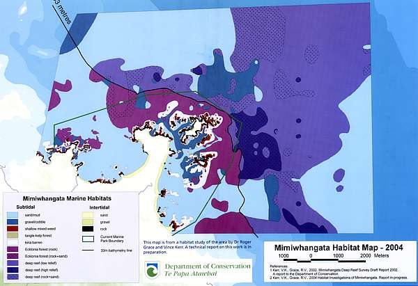
examined the deeper areas offshore. These habitat survey results are shown
on the map in the centre of this document.
The deep reefs off Rimariki Island extend 3.5 kilometres to the east,
and are up to 100 metres deep. The centre of this reef area is highly broken,
with gulleys, crevices and protruding rock in excess of 5 metres high.
At 33-37 metres in depth, the reef community makes a dramatic transition
to a community dominated by filter feeding invertebrates. Beyond this depth,
the kelp forests of the shallow reef areas no longer grow due to lack of
light. Soft corals and sponges dominate this deep reef invertebrate community.
In biological terms, this deep reef habitat is very rich in both diversity
and abundance. Known as high-relief deep reefs , the contour of this
habitat is especially complex, consisting of gulleys and pinnacles averaging
three metres or more in height (see habitat map). The physical complexity
of this reef system (and the passing currents)
increases the diversity and abundance of the reef. Surrounding it are large
areas of low-relief reef and patch reef areas, where reefs are broken by
sand and cobble bottom. This reef system is considered to be representative
of northeast coast near-shore reef systems, to a depth of 100 metres.
To the north and south, the areas of patch reef change to sand areas.
Mimiwhangata is already highly valued as an ecological, cultural and recreational
area. If it is fully protected, many people from all over Northland, New
Zealand and the world will be able to experience and treasure this varied
marine environment in a natural, thriving state. If
you are also able to stop degradation which has accelerated steeply over
the past 15 years, and also facilitate access, but who will be able to
experience anything found deeper than 30m outside the present boundaries?
Mimiwhangata is a well studied part of New Zealand s coastline, which
complements other east coast areas where extensive study has taken place
e.g. Poor Knights Islands, Cape Rodney to Okakari Point (Leigh) Marine
Reserve. Scientists have been surveying Mimiwhangata over a 30 year period.
People have fished there for centuries and a lot is known about the area.
If Mimiwhangata is designated as a Marine Reserve, it will be possible
to study how well and how quickly the recovery takes place. Do
we really need yet another study whether marine reserves do work? We already
have so much failed research that taught us nothing about the environment.
Mimiwhangata will add a valuable array of protected habitats to an
emerging network of protected areas along the northeast coast of New Zealand.
This will be useful in many ways. It will allow people to understand and
experience a coastal environment in a near-natural state. It will also
provide much needed information about the marine ecosystem to guide management
decisions for the whole coast. We have wasted 15
valuable years doing nothing about marine degradation. How many years before
effective management decisions are made? The knowledge is there, all brought
together on the Seafriends web site. The problem with Mimiwhangata is that
it is of little value for marine research because it is special, unlike
the more representative stretches of coast. It is there that scientists
must clamour for their marine reserves. Furthermore, it is highly questionable
whether marine research done with Baited Underwater Video will have any
relevance to the management of our coasts and fisheries!
Mimiwhangata has a special environment, containing examples of almost every shallow marine
habitat on Northland s eastern coast.
From Left to Right: 1. A packhorse crayfish with a group
of smaller red crayfish. 2. A leatherjacket nibbles at sponges on
a rock wall. 3. This spotted black grouper lived in a particular
hole at Mimiwhangata for approximately five years. Why
has it gone? 4. Porae are frequently found where the sand
meets the rocks. Inside the MMP?
How damaged is Mimiwhangata s marine environment? To answer this question, DoC has been studying and measuring changes
in individual (fished) species, and changes
to the Mimiwhangata habitat over time (2, 3, 4, 6, 10, 11) . Some of these
changes are believed to be primarily a result of fishing impacts, while
others are a result of natural changes or other factors which are not yet
fully understood.
Changes due to fishing impacts Crayfish Packhorse crayfish numbers declined in the 1970s and 1980s. They are
now very hard, if not impossible, to find in the Marine Park. The
numbers have fallen despite commercial taking of packhorse crayfish from
the Marine Park being banned in 1994. There were some significant
increases of young red crayfish in the 1970s. Scientists thought this would
result in adult crayfish numbers increasing as the young crayfish aged
and the Marine Park system reduced fishing, but this did not occur. Red
crayfish numbers have remained much the same during the past 20 years with
no significant increase in the number of larger crayfish. It appears that
the current level of crayfish taken by recreational divers in the Marine
Park is enough to keep the crayfish numbers consistently low in the shallow
reef areas. Packhorse crayfish have not returned
to any of our other marine reserves, including the Poor Knights and Goat
Island. For crayfish to return, there must also be suitable crayfish habitat,
which is not the case in the MMP, as it is also lacking from Tawharanui.
Fish Prior to the 1970s large snapper were frequently seen and caught at
Mimiwhangata. Anecdotal reports from this period suggest that commercial
trawling, long lining and set netting were gradually reducing the numbers
(12). Commercial fishing ceased in the Marine Park in 1993. In recent surveys,
young snapper have been infrequently seen at Mimiwhangata, but there are
few older, large snapper. In a 2002 survey, it was found that Mimiwhangata
had fewer and smaller snapper than Cape Brett, the Mokohinau Islands and
the Poor Knights Islands. There was also no significant difference in snapper
numbers between the areas inside the Mimiwhangata Marine Park, and reference
sites outside but near the Marine Park. Preliminary comparison of data
from historic sample areas within the Marine Park shows little change in
the abundance of reef fish. Analysis of the latest survey data is currently
in progress.
Kelp forests There are some spectacular examples around Mimiwhangata of kelp forest
decline. For example, at Pa Point in 1976 there was a lush, tall, dense
forest of kelp. By the early 1980s the extent of the forested areas was
decreasing, and by summer 1986 (and continuing to 2003), only sparse remnants
of the kelp forest remained. This change is influenced
by an increase in kina, which feed on the kelp forest. This
increase may occur because the predators of kina, such as large snapper
and crayfish, are now less common in the shallow reef areas. As a result,
the kina have drastically increased in number, impacting on the kelp and
creating areas which are now commonly referred to as kina barrens . This
is a major habitat change to a less productive state, with possibly serious
ecological impacts. Again, the urchin barrens myth.
Where is the data measuring kina densities? Other factors which
may affect the kelp forest growth and decline are storms, algae blooms
and variations in ocean temperatures (and primarily
degradation). (Please see photos top of page 10).
Photo provided by Seafriends
There is something else happening to
the kelp forests in a wide region ranging from Great Barrier to Cavalli
Islands. The above photo, taken at Arid Island NE Great Barrier Island,
shows how the kelp forest diminishes in the absence of kina, as it is replaced
by turfing coralline algae. This is caused by a chronic lack of light due
to murky waters, one aspect of degradation.
Changes due to natural or other causes Noticeable now at Pa Point are increased silt
deposits, starfish species in abundance, and significant invasion of the
exotic parchment worm which smothers the indigenous encrusting reef life.
These
are all very strong indicators of degradation, as is the demise of tuatua
shellfish beds.
Oysters Rock oysters have almost died out in parts of the Marine Park. This
could be due to natural causes which are not fully understood, but the
decline may have been hastened by significant harvesting in the 1981-82
summer, and may be due to Pacific oysters arriving in the area in the late
1970s.
Tuatua Tuatua numbers fell from beds of 10 million small tuatua in the 1970s
to around 800, 000 middle-sized to large tuatua in the 1980s and since
then they have almost disappeared. In recent years, tuatua have been hard
to find on Mimiwhangata Beach, although occasional individual tuatua are
found on all the sandy beaches in the area. The natural fluctuations and
various causes for these fluctuations of tuatua populations are not well
understood, therefore the dramatic changes measured at Mimiwhangata over
the last three decades may be due to natural causes, as opposed to human
harvesting. Note that the shellfish of Cheltenham
Beach (Takapuna, Auckland) are not coming back, even after a prolonged
period of protection. Why?
Scallops Small numbers of large scallops (e.g.. 120mm) were often found in the
coarse sand sediments between Rimariki Island and the mainland in the 1970s
surveys. These rapidly declined and were not found in the 1980s surveys.
More recently (March 2004), scallops were reported washed up in considerable
numbers on Mimiwhangata Beach after a very large northeasterly swell event,
indicating there are still some scallop beds remaining in Mimiwhangata
Bay. No other information on scallops was gathered in the 2001-2004 surveys.
The impact of human activity on scallop populations at Mimiwhangata is
unclear.
From Left to Right: 1. Rock oysters have become less common
at Mimiwhangata. 2. Tangle weed kelp. Healthy kelp forests such as
this are now less common at Mimiwhangata. 3. In this aerial shot,
the dark patches are kelp forest, while the light-coloured areas of rock
are areas of kina barren.
From Left to Right: 1. Tuatua underwater at Mimiwhangata
beach. 2. A sample of tuatua surveyed on Mimiwhangata beach in the
1970s. 3. This scene is typical of a "kina barren", where kelp forests
are eaten by the increasing number of kina. Taken
in the MMP?
The tangle weed or flexible weed (Carpophyllum
flexuosum) is repeatedly mentioned as if the writers are unfamiliar
with its ecology. This seaweed belongs to sheltered waters and survives
in rather degraded conditions. However, along exposed coasts where it does
not belong, it may occasionally be found in stunted form after a long absence
of storms. For the MMP, tangle weed is a non-event.
Left: This 1950 aerial photo shows lush dark-coloured tangle
kelp forest around the reef off Pa Point.
Right: The same area in 2003 shows dramatic reduction
of kelp cover and its replacement by pale-coloured kina barrens. It
is dangerous to compare photos of unequal quality. Tangle kelp does not
belong to an exposed coast. Besides, urchin barrens come and go, particularly
where the sand is shallow as in this example. Refer to the habitat map
to see for yourself that the urchin barrens are but a small part of the
kelp zone and a very small part of the total MMP.
Ecological Connections
From Left to Right: 1. A red crayfish lurking under a rocky
ledge. 2. Snapper eat small kina. Remove too many snapper and the
kina multiply. 3. The tangle-kelp, Carpophyllum flexuosum
, was once abundant at Pa Point. 4. The common kelp, Ecklonia radiata
, forms extensive forests at Mimiwhangata, but has been reduced in the
shallow part of its range by grazing kina. 5. Large numbers of kina
damage the kelp forests. This imbalance may be corrected in a marine reserve.
Please
state where these photos were taken.
Reader, the photo of the snapper
escaping with a kina was taken at Goat Island by Dr Floor Anthoni
on 25 Feb 2000. DoC 'used' it for no remuneration, no permission, no acknowledgment.
How much deeper can it sink?
How did this happen? The threat of over-fishing along Northland s eastern coast has been
discussed by Northlanders since the 1950s. Each decade has brought renewed
concerns over visible reductions in numbers of crayfish, snapper, trevally
and hapuku from nearby coastal reefs. At Mimiwhangata, discussion documents
from the 1970s describe heavy commercial fishing pressure on this part
of the coast.
Some accounts describe pair trawlers operating in Mimiwhangata Bay (12).
As a result, the marine environment was starting to show significant decline.
The Marine Park was established in a bid to protect and restore the Mimiwhangata
marine environment. There are a number of possible reasons why the Marine
Park concept has not delivered positive results at Mimiwhangata. These
reasons may have resulted from the environment responding differently than
expected, may involve changes in human impacts over the time period or
possibly combinations of both. Examples of possible reasons include:
Environmental degradation foremost
Slower rates of reproduction than were expected in some species
Increased visitor/fisher numbers as road access improved and
the number of boat owners increased
Increased boating activity, size of boats, number of fishers per boat and
use of electronic fishing aids
Increased fishing and shellfish collecting in and around the Marine Park
The complexity of the fishing regulations that were established for the
Marine Park
Poor signage at boat ramps
Uncertainty in public perceptions of who was responsible for the Marine
Park, with DoC responsible for land and the Ministry of Fisheries being
responsible for the Marine Park regulations
Lack of interest from the Ministry of Fisheries
Poor policing and education
Lack of visible positive results being measured and reported back to the
community
Lack of timely monitoring
Lack of allocated resources to manage the Marine Park and to enforce the
Parks fishing restrictions.
Lack of local management with a budget.
Mimiwhangata Marine Park is an area that is pleasant to visit and
to fish in. As a result, it may be more heavily fished than other coastal
areas, possibly creating the opposite result to that intended. Allowing
for selective fishing methods may encourage people to fish even more in
the Marine Park, because there may be a perception amongst fishers that
fish will be larger and more plentiful under the partial protection rules
of the Marine Park.
The proposed marine reserve option It is possible with community and iwi support to establish a fully
protected conservation area at Mimiwhangata by establishing a Marine Reserve.
The Marine Reserve option at Mimiwhangata represents a change in objectives,
from a combined fishery and conservation objective, to an objective that
is solely focused on protecting the area in as natural a state as possible,
for study and enjoyment of the community. The Marine Reserve concept makes
use of a simple management rule that is easy for people to understand.
4. Marine reserves What is a Marine Reserve? Marine Reserves are the national parks of the sea, where underwater
features and marine life enjoy complete protection. Their legal purpose
is to protect areas of New Zealand that contain underwater scenery, natural
features or marine life, of such distinctive quality or so typical or beautiful
or unique, that their continued preservation is in the national interest.
Because much of our underwater environment has been altered by human activities,
we need to protect parts of the sea that closely represent examples of
what was originally there. Within a Marine Reserve, marine life is left
to recover and flourish in its natural state - for its own sake and for
future generations to study and appreciate. It provides a rich environment
teeming
with hundreds of species of sea life.
This provides a safe breeding environment
that has the potential, in time, to increase the quantity and quality of
marine life available outside the reserve. As with national parks, people
are encouraged to visit, explore and learn from Marine Reserves. Most Mimiwhangata
locals know that the area is not as bountiful now as it was in the old
days. A Marine Reserve may help recovery of the marine environment and
species, and protect marine life for the benefit of present and future
generations.
Again a long paragraph aimed to deceive.
To make comparisons between terrestrial national parks and the sea is meaningless.
Not just because the sea is an entirely different environment, but also
because our national parks cover the wastelands and they are still teeming
with introduced pest, offering little protection to our sensitive native
species, many of which have no hope of salvation. On land we have changed
over 80% permanently and irreversibly so. And global climate change is
still to wreak havoc there.
By contrast, the sea is productive everywhere
and accessible too. It is least disturbed because we don't live there,
farm the sea bottom, build motorways and so on. Locking parts of the sea
up means also forfeiting benefits to future generations. In a civil society
this is not done when the disadvantages outweigh the benefits, which is
the case with most of our marine reserves so far. Worse still, those promoting
such reserves have not even taken the trouble of evaluating assets versus
liabilities, which is disrespectful.
One can take offence with the purism expressed
by pro-reserve lobbyists who apply one standard for the land and a much
more stringent standard for the sea. The reality is that this planet has
been swamped by 6,000,000,000 individuals of our kind, far more than any
other species of even half our size, and this will almost double within
30 years. Where people tread, nature yields. A new nature emerges
capable of our abuse and also exploiting us. Something likewise
happens in the sea. A new nature, which in the sea is not radically different
to what in our minds is the pristine situation. The good old
days cannot come back, however hard we try, and in the face of rampantly
accelerating pollution, is now further away than it ever was.
If we truly want to save the sea, rather than
building empires of networks of unnatural enclaves, we must focus
on the sea's number one threat, that of land-based degradation, and must
manage our fishing with larger stocks. These measures will do far more
than marine reserves ever will. Only by saving the land can we save
the sea!
So
many people make much ado about the environmental damage caused by fishing
and trawling but why is it then that marine environments recover so quickly
after fishing stops? The answer must be found from understanding how the
food pyramid works, see the diagram on right. By far the largest amount
of food is made by phytoplankton, which from necessity cannot grow
even as large as visible specks in the sea but we can observe it as mist.
Tiny animals in the zoo plankton however, feast on it, grazing the
plant matter and converting its solar energy into larger parcels (themselves).
These in turn are eaten by larger animals like fish larvae, which in turn
are eaten by bait fish until finally the table fish consume them. It explains
why marine creatures produce so much spawn, 99.999% for making food, rather
than procreation. Note that each higher tier is very much smaller in biomass
than the one beneath, due to losses in energy and wastes. Fishing now consists
of taking a bite from the very top tiers, which amounts to only a very
small bite from the whole. By contrast, degradation takes a bite from the
bottom tiers, thereby profoundly affecting all tiers above. This has made
degradation the largest threat by far. The bottom line is that a ban on
fishing has very little effect on the whole ecosystem and it explains why
all of our marine reserves are performing so badly. Do we need more failed
marine reserves? Obviously a moratorium on marine reserves is needed
in order to be able to iron out all myths and fallacies and to be able
to do the right thing for the right reasons at the right time. We owe it
to our children.
How is it different from a Marine Park? Mimiwhangata Marine Park was set up under fisheries regulations and
a Grant of Control under the former Harbours Act, which was superseded
by the Resource Management Act 1991. In simple terms Marine Parks are a
set of agreed rules for activities (normally fishing) in a defined area.
Mimiwhangata has allowed limited fishing. In contrast, Tawharanui Marine
Park does not. Tawharanui demonstrates that full
and permanent no-take protection is easily done under the Fisheries Act.
The current Mimiwhangata partial protection rules under the Fisheries
Regulations are summarised on page 14.
All commercial fishing ceased as of October 1993. Packhorse
crayfish protected in 1994
Amateur fishers may only use unweighted, single-hooked lines, trolling,
spearing and handpicking to take fish and shell fish species listed
as:
Other species: All other species of finfish, shellfish and other
marine life are totally protected.
By contrast, Marine Reserves are no-take zones,
focused on preservation of marine habitats and life for scientific study.
The clear and simple no-take rule makes Marine Reserves easier to monitor
and enforce, both through community action and legal action if necessary.
There is recent evidence based on research at the Poor Knights Islands
Marine Reserve, that conservation outcomes are more significant in a Marine
Reserve than in a partially protected area (13).
Oops, poppycock! Let's now check out the situation
at the Poor Knights Islands where fishing was stopped altogether in the
beginning of 1999. DoC paid a whopping $283,000 for a study to demonstrate
that marine reserves work. Snapper numbers indeed increased, but not mentioned
in the report (14) were far more important results shown here.
The graph shows fish density vertically and years
horizontally. Scientists essentially counted fish numbers in a transect
the size of a tennis court. What is significant is that these fish are
not the migrants or weirdos but common fish that belong and breed there.
As you can see, all species tell the tale of chronic decline due to degradation.
But sweep, which does not belong in the clear waters of the Poor Knights,
suddenly became common, replacing the more sensitive blue maomao (not measured!!!),
which is a sure indicator of degradation.
Does the size of the Marine Reserve matter? The best size for a Marine Reserve depends on what you are trying
to protect or study. For some species, a very small Marine Reserve may
be enough to protect a local population. For species that travel or migrate,
a very large Marine Reserve may be required to be effective. Some very
mobile species may only take up temporary residence within a Marine Reserve.
However, the positive benefits of the Marine Reserve may be increased if
the period of the species life cycle spent in a reserve, is a critical
portion of its life (e.g. spawning). Research on the movement of snapper
in and out of Marine Reserves has indicated that fishing for snapper just
outside Marine Reserve boundaries affects numbers in the reserve. Indeed,
marine reserves must also provide for large feeding grounds in deeper water
and spawning grounds too.
Fishing causes species, such as snapper, to be generally less abundant
closer to the edges of reserves, as compared to the centre of the reserve.
For example research at Cape Rodney to Okakari Point (Leigh) shows reduced
snapper numbers near the edges of the five kilometre-long reserve. A bigger
reserve reduces this effect (14, 15, 16).
Fishing outside a marine reserve reduces numbers of species like snapper
inside the edge of the reserve. In larger marine reserves the edge effect
is a much smaller proportion of the total area.
The illustration above shows a possible model
of the edge effect close to the Marine Reserve boundary. Larger Marine
Reserves enable a wider range of habitats to be protected. The Mimiwhangata
area is rich in habitat diversity. The largest possible area under protection
will allow for more of these habitats to function fully and have a greater
potential contribution to the overall coastal system. Larger overall size
will minimise effects from fishing at the edges of the reserve, and would
potentially
add more diversity and more marine habitats to the network of marine protected
areas in northeast New Zealand.
Benefits inside the reserve boundary When a no-take area is established, it assists
recovery of the environment to a state which is more comparable to its
condition before it started to decline. Recovering
habitats become nurseries (kohanga) in which the
sea life grows bigger, more plentiful and varied than in surrounding
fished areas. Bigger animals produce substantially
more young. When more young are produced, they may drift or swim into the
surrounding areas.
Another paragraph to deceive more gullible
people. As we have shown extensively before and on the Seafriends web site,
our coastal seas CANNOT return to their condition before their decline
unless we clean up the water by saving the land. Make no mistake about
this. None of our coastal marine reserves have produced more and bigger
sea life (some fished species, yes) and more varied because they are all
degrading. This can easily be verified, but the fact is that DoC does not
make funds available to do so. Business people know that what is not
measured, is not managed, and they can therefore rightfully accuse
DoC of poor management, because it does not know whether our marine reserves
are getting better or worse. To make matters worse still, DoC is spreading
the FALSE expectation that they do, insisting on MORE FAILED RESERVES everywhere.
How can common-sense justify this?
Although it can be demonstrated that in marine
reserves the fished resident species produce more spawn, this bears no
relationship with the number of recruits produced elsewhere. Fish spawn
prolifically to make food (99.999%), rather than offspring (0.001%).
Sea Life Increases Dramatically Studies of more than 80 Marine Reserves all over the world have shown
that the average weight of exploited species is more than four times greater
in reserves than in unprotected areas nearby. The average number of animals
in an area triples, and the number of species is 1.7 times higher in Marine
Reserves than in unprotected areas.
The average body size of animals is 1.8 times larger in reserves than in
fished areas. These findings include not just fished species but other
plants, invertebrates and fish (8). In most cases, studies of changes in
Marine Reserves established in New Zealand show a similar pattern of large
increases in the average size and numbers of exploited species accumulating
in the reserve (7, 18, 19). At the Poor Knights Islands Marine Reserve,
snapper numbers have increased dramatically inside the Marine Reserve (17).
The most gullible of all are scientists
themselves. The study referred to, lumped all marine reserves together
and came up with a figure, without distinguishing those in heavily exploited
tropical seas from well managed ones in temperate seas (NZ). When each
of the examples is analysed separately, it becomes clear that by far most
of the (fishery) benefits resulted from improved fisheries management and
forced retirement. Read Myths2 for all
the details and further references. It has furthermore been shown that
most of the studies included in this report cannot be trusted for their
robustness, in other words, they are poor science. Read Myths6
and
Burdens of Evidence (260KB PDF) (15)
for the whole story.
This chart shows the number of snapper sighted using a Baited Underwater
Video (BUV), at sites within and outside three marine reserves around New
Zealand in the same calendar year. As you can see, there is a large difference
between the figures at each location (4, 15, 17).
The graph presented here is derived from a DoC-funded
study by Willis, Millar and Babcock (16). This study compared three marine
reserves with reference areas nearby. Apart from the fact that all three
reserves occupy special habitat, whereas the reference areas do not, the
actual results do not look quite as shown above, as you can verify. Fig
2a counts all snapper, 3a legal size snapper and 3b sublegal size snapper.
(2b represents cumulative biomass.) Apparently, DoC's chart refers to the
most favourable result for legal sized snapper only, but even then it has
taken only the most favourable point in April1999. We ask ourselves
whether this is a fair representation and if it is not, why do scientists
debase themselves to this level? Why are other scientists not correcting
this misrepresentation of facts, and why does DoC resort to such tactics?
Another fact withheld is that marine reserves recover within one or two
years for adult snapper, who migrate there from outside.
We also have serious doubts about the method used
to count fish, the Baited Underwater Video (BUV) because it defies important
scientific principles of measuring apparatus as it influences the quantity
measured. In doing so, it exaggerates. The BUV method and all results obtained
with it should be disqualified as scientific. Read science
exposed.
Fig. 2. Mean reserve (filled symbols) and non-reserve (open
symbols) snapper Pagrus auratus relative density at Leigh, Hahei
and Tawharanui from November 1997 to April 1999. (a) Total numerical relative
density, all size classes (MAXsna); (b) relative biomass.
Fig. 3. Mean reserve (filled symbols) and non-reserve (open
symbols) snapper Pagrus auratus numerical relative density at Leigh,
Hahei and Tawharanui from November 1997 to April 1999. (a) Fish > minimum
legal size (LEGsna); (b) fish < minimum legal size (JUVsna).
This chart shows crayfish numbers within Cape Rodney to Okakari Point
(Leigh) Marine Reserve, compared to those outside the reserve. Natural
fluctuations in crayfish numbers are likely to have caused the decline
in 2000. Despite this drop, there is still a marked difference in numbers
at each site (20, 21, 22). The crayfish walk-out
in 1998 was caused by a prolonged period of spring rain storms, reducing
the water's quality considerably. It is cynical to call this a natural
fluctuation. Although two groups of scientists were working with crayfish
at the time, and Floor Anthoni reported the loss of crayfish three times
to the Marine Laboratory, scientists still don't know what had happened!
Note that the graph covers a long period of high densities (1980 to1998=
18 years) followed by four years of much lower densities of mainly young
crayfish. Why this misrepresentation?
There appears to be an undue focus
on snapper and crayfish to the detriment of those fish species that have
actually enjoyed most protection. Where is their data?
Benefits beyond the boundaries of Marine Reserves Marine Reserves frequently contain more sea life
than surrounding waters do, so some animals may move outside the reserve
to avoid competition for food and space (18). This is called spillover
(19). Spillover increases as time passes and the sea
life gets more crowded in protected areas.
Different species spill over at different rates, depending on how mobile
they are. Species that are attached to the sea floor, like mussels and
other shellfish, do not migrate outside reserve boundaries but potentially
export large volumes of larvae to coastal waters. Fish species that we
think of as migratory may simply pass through reserves or stay temporarily.
Experience however has also shown that there are many surprises with
Marine Reserves. For example, at the Poor Knights Islands and at the Cape
Rodney to Okakari Point (Leigh) Marine Reserve, snapper have displayed
residential and semi-residential behaviours to a surprising degree (7)
[true].
This leads to the conclusion that Marine Reserves offer the best opportunity
to understand the natural behaviour of fish, and in particular of old large
fish, as their numbers are so depleted in fished coastal reefs [false].
Again an attempt to deceive. More sea
life above, means more of some fished species. In a working
marine reserve, however, the total amount of sea life diminishes rather
than increases, because the larger predators (and grazers) need to
be fed. In the process some 70-90% of what they eat is wasted. Thus also
the total spawn mass from a successful marine reserve becomes less than
from its surroundings. Protagonists often claim that spillover benefits
fisheries, but forget to mention the lost fishery inside a marine reserve.
Practical studies have shown conclusively that spillover is substantially
less than the lost fishery, which stands to reason, as one does not wish
the breeding stocks to spill out.
Scientists seem surprised about residential behaviour
of migrant species. They seem unaware that the sea has hot spots
where fish like to be, and once their numbers increase, these attract more
fish. Goat Island, jutting out into clearer water and currents, offering
shelter while close to feeding grounds, is such a place. Islands are so
too. It so happens that most of the marine reserves (I think ALL) are located
in special places, so observations in such reserves must be interpreted
with care. However, protagonist scientists do not take such care, to
the extent that no marine science done in NZ can be taken seriously any
longer. This is an important message for the public! Distrust everything
scientists say, as substantiated by these rebuttals.
How quickly do Marine Reserves work? The recovery speed for marine environments varies depending on how
quickly sea life normally grows in the area. Some animals grow quickly,
mature at an early age and produce large numbers of young. These animals,
such as scallops and mussels, may multiply rapidly after protection, sometimes
increasing significantly within a year or two. [true]
Other animals grow slowly and mature later in life. These species, such
as hapuku, some reef species, and the large old individuals of faster growing
species, may take many years or even decades to increase noticeably in
a reserve. All these changes contribute to food webs and ecological interactions,
which may require even longer time periods to realise the full range of
benefits and rehabilitation [false].
When fishing stops, changes happen immediately.
First fast, then more slowly until finally a kind of equilibrium is reached.
It is therefore ecologically illogical to expect sudden changes at a late
age. If hapuku, groupers, packhorse crays and others are expected to return,
then their most decisive years will be the first years after which they
only grow larger. Yet in none of our marine reserves this has happened.
Obviously something is holding them back: degradation. For the last
sentence, refer to the urchin barrens myth which has been destroyed
decisively.
Below Left: A close-up view of a leatherjacket amongst
lush sponges
Upper left: The goatfish uses two barbels under the chin
to search for worms and crustaceans in the sand.
Below Right: At the Cape Rodney to Okakari Point (Leigh)
Marine Reserve, snapper of legal size are 10-20 times more abundant
than on the
unprotected coast. Hot spot?
Below Left: A crayfish peers at the camera.
Upper Left: Kina can be collected from Mimiwhangata Marine
Park under the current regulations.
Below Right: Kingfish are a feature of Northland coastal
waters. Photos from inside the MMP? We think not.
Below Left: Sponges and plankton-feeding demoiselles
on the deep reef. Inside the MMP? Below Centre: An aggregation of goatfish near a reef.
Below Right: A school of snapper peers at the camera
at Cape Rodney to Okakari Point (Leigh) Marine Reserve.
From Left to right: 1. Paua numbers are likely to increase
in a Marine Reserve at Mimiwhangata. 2. The spikes on the legs of
large red crayfish are used to crack kina. 3. Marine Reserves are
the only place where divers can regularly see snapper at close range.
4. A selection of sea life, which lives buried in the sandy seabed.
5. A large sponge and soft coral on the deep reef.
Below Left: Large old snapper are the best breeders and
are only protected in marine reserves.
Upper Left: A nest of red crayfish at Leigh Marine Reserve
Below Right: Hapuku, once common in shallow water, are
now thought of as deepwater fish. They may
return to the shallows in a marine reserve. Has
this happened anywhere?
Now have a look at photos actually taken inside
the Mimiwhangata Marine Park, May 2003 Photos provided by Seafriends
In the shallows, fringing the exposed reefs, one finds the
strap weed Lessonia which indicates this area's similarity to places
like the Poor Knights. The strap weed thrives in strong wave action.
Stunted tangle weed on colourful urchin barrens. The tangle
weed cannot grow tall because it is not strong enough, but its thin woody
base discourages urchins from eating it. Notice the Sandager's wrasse which
is an indicator of warm, clear water.
Where the rocky shore is deep enough (10-15m) and bordered
by shallow sand, urchins gather at its base after being swept off. Then
they attack the kelp forest from below as well as from the top, resulting
in barren zones wider than usual. This is not a sign of degradation.
Along a vertical wall, the usual fauna has disappeared, but
just this year a crop of soft corals or deadman's fingers (Alcyonaria
sp) popped up, their transparent polyps glowing in the blue light. Finding
a crop of individuals of the same age while other age classes are absent,
is a sign of decay.
Only in a few small places, dominated by shelter and strong
currents, finds one remnants of what once lived here profusely and even
these communities have changed already.
In sheltered places one finds the strongest indicators of
decay, like this steep rock face smothered in sticky dust, which has killed
all life except for some hardy cup corals. Note that the dust does not
even show trails of grazers.
5. The Mimiwhangata Proposal
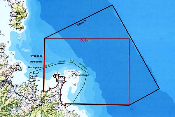
Proposed boundaries At this stage two options for the boundary of the proposed reserve
have been put forward by the biological survey team, representatives of
tangata whenua and Department of Conservation staff. These are outlined
on the enclosed map. A considerable body of information on the marine habitats
of Mimiwhangata has been collected and is still being analysed. [Why
have the largest stakeholder groups, those who are expected to make a sacrifice,
the fishermen, been excluded from discussions? Is this real consultation?]
The area investigated
extends approximately four kilometres offshore and includes significant
areas of reef and soft-bottom habitat beyond the current one kilometre
Marine Park boundary. The proposed boundaries attempt to include all the
major habitats at Mimiwhangata in one reserve. This includes the sand areas
to the north and south of the main deep reef.
These soft-bottom habitats have a very different range of invertebrate
communities, as compared to the reef habitats, and are also important feeding
areas for large mobile predatory species. It is important to include these
soft-bottom and sand areas around reef edges, as many marine organisms
periodically move out from reef habitats to these sand areas. These boundary
designs will allow for maximum protection of biodiversity, and for organisms
to move freely between habitats at different stages of their life cycle,
benefiting from full protection. [true]
This information is summarised on the double page insert map (below)
and on the questionnaire. You are invited to comment on the proposed boundaries
and how they might affect you. The technical reports supporting this information
are listed as footnotes throughout this proposal and can be requested along
with reports now in progress (as they become available), from the Department
of Conservation s Northland Conservancy Office, P O Box 842, Whangarei.
[The
present size of the marine reserve is 20km2, about four times larger than
Goat Island's. The proposed area extends this to either 70 or 100km2]
Proposed traditional management area In preparing this proposal, discussions were held with hapu representatives.
Kaumatua and Kuia from the Mokau area (adjacent to the western end of the
proposed Marine Reserve boundary) indicated a strong preference for having
the area around Paparahi Point, which is currently within the Marine Park,
excluded from the proposed Marine Reserve area.
The Department of Conservation has taken this advice in formulating the
proposed boundaries (see attached map). The hapu view is that this area
has always been intensively used for kaimoana harvesting, and in modern
times has become especially important as a recreational, subsistence and
customary fishing area for both the hapu and the wider community. It was
argued that the shelter, easy access and strong significance of the traditional
use of this location, meant that this area would be better managed under
a system different to the Marine Reserve.
Some of the objectives identified by the hapu for management of this
area were:
restore the understanding and use of tikanga, (traditional rules and boundaries)
for the management of this area
create local on-the-water involvement and employment for the people of
the hapu and community
investigate the potential for aquaculture to take pressure off the harvesting
of the natural reef system, and possibly to enhance the natural reef system
restore the kelp forest community, paua, mussel and crayfish resources
of the Paparahi Point area. What about kina?
Beyond the specific area of Paparahi Point and its reefs and islets,
the hapu did not wish at this time to draw lines indicating the extent
of the area they wished to focus on to develop traditional management practice.
In their view the Paparahi Point area is simply one part of the entire
rohe for which they are responsible as Kaitiaki. They also stated that
they would be seeking to explore the extent to which provisions in the
Fisheries Act could support their traditional management objectives, referring
here to Mataitai and Taiapure areas as defined by fisheries regulations.
Notice how we'll end up with two different
acts and two different bureaucracies managing the area? If it was all done
under the Fisheries Act, it would be much simpler. The time has come
to abolish the Marine Reserves Act altogether. It is an anomaly whose time
has passed.
How would a Marine Reserve support kaitiakitanga? Respected Ngatiwai and Mokau Kaumatua, Houpeke Piripi, has declared
a rahui tapu at Mimiwhangata and supports the use of the Marine Reserves
Act 1971 to restore the area. Houpeke and the Te Au O Morunga Marine Farm
Trust have also proposed an adjacent traditional management area (see enclosed
map).
The hapu also saw it as an advantage to develop kaitiakitanga management
of the Marine Reserve and of special areas surrounding the Marine Reserve
identified by hapu and the Department of Conservation.
The Department of Conservation, in preparing this proposal, acknowledges
the leadership and vision demonstrated by Houpeke and the other Kaumatua
and kuia involved in the investigation stage of this project. With their
leadership and guidance, we will seek to take the kaupapa of this proposal
to the wider tangata whenua community and Ngatiwai iwi.
Marine Reserves offer a mechanism for tangata whenua to be intimately
involved in the long-term protection and recovery of special areas in their
rohe. There are many concerns about the long-term impacts of increased
fishing pressure on the marine environment. The Marine Reserve proposed
at Mimiwhangata would create a refuge or nursery,
where natural productivity could recover and support management
efforts in the adjacent coastal areas.
The MRA1971 under which this proposal
is sought, does not support kaitiakitanga. A marine park under the fisheries
act would give the local communities a better and more flexible vehicle
to manage their resources for the future.
Establishing a Marine Reserve: How the process works The process for establishing a marine reserve in New Zealand is set
out in the Marine Reserve Act 1971, and is illustrated by the diagram at
the top of the page (below). This proposal
represents Step Four of this process, and is an informal discussion document
which creates the opportunity for all interested parties to comment before
it is advanced to a formal application stage (Step Six).
It is important that every interested person or group now has a chance
to have their say. Proposed boundaries have been presented and will be
reassessed at the conclusion of this first round of informal public discussion.
Any changes will be based on the submissions received, further consideration
of the benefits of the proposal and any adverse effects that become apparent.
Following the three-month submission period for this proposal document,
the Department of Conservation will analyse the feedback received, conduct
further discussion and consider scientific information about the area.
Then a set of boundaries may be proposed in a formal application (Step
Six) for a Marine Reserve or the proposal may
be abandoned altogether. The public would have the opportunity
to make submissions on the application (Step Seven), as part of the statutory
process.
Following the application period, there are several steps where the
Minister of Conservation examines objections to the application, makes
a decision and seeks concurrence from other Ministers.
The Marine Reserve Process (See also our
more extensive process chart)
1. Define objectives and form a team
2. Initial consultation with interest and user groups
3. Site survey and investigation
4. Draft proposal formulated and released for public comment (We are
here)
Overwhelming adverse reaction -> NO
MANDATE, NO RESERVE 5. Prepare a formal application
6. Formal application is made to the Director-General of Conservation
(DG)
7. Public notification of application
Objections received
8. Applicant may answer objections
9. DG forwards application, objections and answers to Minister of Conservation
(MoC)
10. MoC considers objections - upholds objections -> NO
RESERVE
Does not uphold objections -> process continues
11. MoC seeks concurrence from Ministers of Fisheries and Transport
and consent of a local authority sought if required.
No concurrence/ consent -> NO RESERVE
Concurrence/ Consent given -> process continues
12. MoC makes recommendation to Governor-General for an Order in Council
13. Marine Reserve order signed by Governor-General
14. Marine reserve established. Marine reserve comes into force 28
days after notification in the NZ Gazette.
Who would manage the Marine Reserve? The Department of Conservation is responsible for day-to-day management.
The Marine Reserves Bill currently before Parliament provides for the possibility
of advisory committees to be established to advise the Department of Conservation
on management of a Marine Reserve. For example, day-to-day management could
be taken over by community groups. A system of concessions in Marine Reserves
is also proposed, which means the community could be fully involved in
economic activity arising from the establishment of a Marine Reserve in
future. It is important to note that the final provisions of the new Bill
will not be known until it is passed in Parliament.
Oops. This is the first time that local
day-to-day management is mentioned. Why else is none of our marine reserves
managed this way? Let's not be fooled about so-called advisory committees
which have been selected and groomed to yay-say to DoC and which have essentially
only a honorary function. What we need is full local management by those
who know the sea (fishermen), who also manage DoC's management budget.
The system of concessions to fund local management is anathema to traditional
freedom at sea and is used here as an unpalatable carrot.
It is important that everyone now has a chance to have their say.
You can print the questionnaire
stored in easy HTML format on our web site or go to the Option4
web site for a painless electronic submission which doesn't even require
a stamp. But note carefully how this questionnaire has been structured
with leading questions to achieve only one outcome: either your full support
or an ineffective and disqualified opposition.
6. community consultation - the next
steps
At this stage this proposal and discussion is proceeding under the existing
Marine Reserves Act 1971. If the new Marine Reserves Bill is passed through
parliament prior to a formal application for this proposal being lodged,
the information and consultation will be reassessed as part of preparation
of an application under the new Act. Please note
our comments about the Marine Reserves Bill above.
How will the community know if it is working? The environment at Mimiwhangata has been surveyed for three decades
now, and this monitoring will continue. Management systems and community
involvement in the reserve would help to publicise changes that occur there.
People would continue diving, snorkelling and swimming in the area and
would see the changes.
Key Questions This document has described the way Marine Reserves restore marine
environments. It provides information about Mimiwhangata and Marine Reserves,
and an opportunity to discuss a Marine Reserve for Mimiwhangata.
The key questions are:
How would the activities of different interest and user groups be affected
if Mimiwhangata became a Marine Reserve?
What is the compelling reason not to leave it as
a marine park?
What are the expected benefits of the Marine Reserve?
What are its expected disadvantages and cost and
lost opportunities to future generations?
Where would Marine Reserve boundaries go?
What is the compelling reason for making it bigger?
What educational, research, cultural and recreational opportunities
would be created?
What opportunities would be lost?
Where would the economic profits go to?
How would a Marine Reserve (or Park) be managed?
How would the general public be involved?
How would the local fishermen be involved?
How would local tangata whenua be involved? How would they benefit? How
would kaitiakitanga be enhanced?
What should we do now? This proposal is open for public submissions.
We want to ensure that the views of the community are widely discussed
before a decision is made to prepare a formal application for a Marine
Reserve. Therefore, we are seeking your views and comments on this proposal.
The attached questionnaire gives you a chance to have your say. Please
send replies by Tuesday, 12 October, 2004, to:
Mimiwhangata Consultation, Northland Conservancy, PO Box 842,
Whangarei. This document and the questionnaire are also available from:
www.doc.govt.nz/regional-info/001~northland/004~conservation/index.asp
[follow
link under this document's top heading]
Limited numbers of the CD-ROM version of this proposal, which includes
photography and technical reports, are available from the Department Office
on request.
What will happen next? After further consultation with tangata whenua, fishers, interested
groups and the Mimiwhangata community, and consideration of feedback on
this discussion document, DoC may make a formal application to the Director-General
of Conservation for a Marine Reserve or rejects
the idea altogether. It is also possible that the tangata whenua
may choose to be named as the applicant or be the joint applicants with
the Department of Conservation. This is currently being discussed. Have
Tangata Whenua been betrayed?
If an application is made, members of the public then have two months,
from the time the application is notified, to make submissions. The Department
is required to consider concerns expressed in submissions. The Minister
of Conservation will make the final decision on the application which also
requires concurrence from the Ministers of Fisheries and Transport.
Ministers of Fisheries and Transport.
Produced & edited by CPRetc Limited. Design by Aaron Moore* Design.
This document is printed on recycled paper.
All photos by Roger Grace, except Page
1 V. Kerr , Page 4 (aerial photo) courtesy of Northland Regional
Council and Page 13 (Leatherjacket) Warren Farrelly. Map work courtesy
of Information Management Unit, Northland Conservancy.
Oops, Roger, one photo belongs to Floor Anthoni.
References (1) Ballantine W.J., Grace R.V.&W.T.Doak (1973).Mimiwhangata
Marine Report.Turbott &Halstead for New Zealand Breweries Ltd, Auckland.98p.
(2) Grace R.V.&Kerr V.C.(2002). Mimiwhangata Marine
Park Draft Report 2002 -Historic Marine Monitoring Update. Report to Department
of Conservation.
(3) Grace R.V.&Kerr V.C.(2003). Mimiwhangata marine
monitoring programme, summer sampling 2003, update on historic monitoring.
Report to Department of Conservation.
(4) Denny C.M.&Babcock R.C.(2002).Fish survey of the
Mimiwhangata Marine Park, Northland. Report to the Department of Conservation.
Leigh Marine Laboratory.
(5) Grace R.V.&Kerr V.C.(2003). A marine species
list for Mimiwhangata 1973-2004. Report to Department of Conservation,
Northland Conservancy.
(6) Usmar N.R., Denny C.M., Shears N.T.&R.C.Babcock
(2003). Mimiwhangata Marine Park Monitoring Report 2003. Report to Department
of Conservation, Leigh Marine Laboratory, University of Auckland.
(7) Shears N.T.&Babcock R.C.(2002). Marine reserves
demonstrate top-down control of community structure on temperate reefs.
Oecologia 132:131-142
(8) Partnership for Interdisciplinary Studies of Coastal
Oceans, 2002. The Science of Marine Reserves. http://www.piscoweb.org
(9) Department of Conservation et.al., 2000. New Zealand
biodiversity strategy. NZ Govt Press. , 2000
(10) Kerr V.C.&Grace R.V.(2002). Mimiwhangata Deep
Reef Survey Draft Report 2002. A report to the Department of Conservation.
(11) Kerr V.C.&Grace R.V.(2004). Habitat investigations
of Mimiwhangata. Report in progress.
(12) Dart J., Drey B.&R.Grace (1984). Mimiwhangata
Marine Park:Environmental Impact report. Hauraki Gulf Maritime Park Board.
(13) Denny C M & Babcock R C (2004). Do partial marine
reserves protect reef fish assemblages? Biological Conservation 1 Vol 116.
(14) Denny C M, Willis T J, Babcock
R C (2003) Effects of Poor Knights Islands marine reserve on demersal fish
populations. DSIS 142, DoC.
(15) Williis T J, Millar R B, Babcock
R C, Tolimieri N (2003) Burdens of evidence and the benefits of marine
reserves: putting Descartes before des horse? Environmental Conservation
30:97-103.
(16) Willis T J, Millar R B, Babcock
R C (2003): Protection of exploited fish in temperate regions: high
density and biomass of snapper Pagrus auratus (Sparidae) in northern New
Zealand marine reserves. Journal of Applied Ecology (2003) 40.
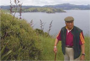 We are children
of the sea. We need to take care of our sea food, no matter what they are,
because they are becoming very scarce or near to
extinction, because of the shortage of food for them. Even
rare species of fish are gradually disappearing. I myself feel that
there should be a ban or a Rahui Tapu placed for at least twenty to twenty
five years, to allow the sea weed to regenerate so
the rare species of fish, crayfish etc. will return and grow, for
our posterity to come.
We are children
of the sea. We need to take care of our sea food, no matter what they are,
because they are becoming very scarce or near to
extinction, because of the shortage of food for them. Even
rare species of fish are gradually disappearing. I myself feel that
there should be a ban or a Rahui Tapu placed for at least twenty to twenty
five years, to allow the sea weed to regenerate so
the rare species of fish, crayfish etc. will return and grow, for
our posterity to come.
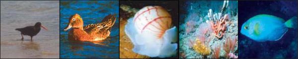
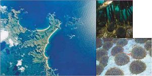
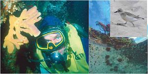
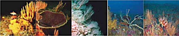
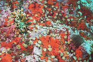
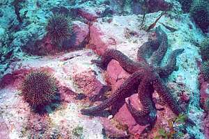
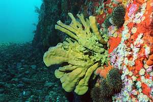
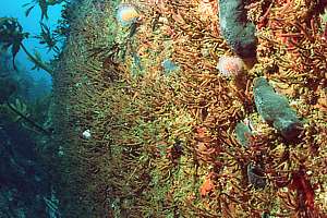
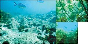
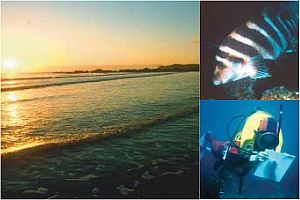
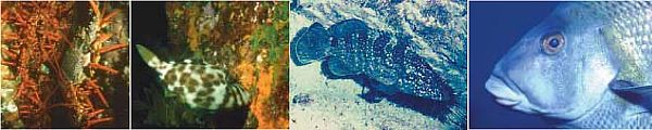
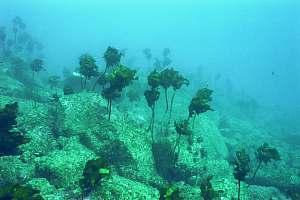
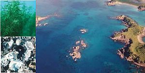
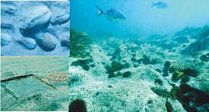
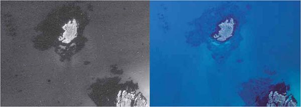
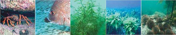
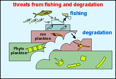 So
many people make much ado about the environmental damage caused by fishing
and trawling but why is it then that marine environments recover so quickly
after fishing stops? The answer must be found from understanding how the
food pyramid works, see the diagram on right. By far the largest amount
of food is made by phytoplankton, which from necessity cannot grow
even as large as visible specks in the sea but we can observe it as mist.
Tiny animals in the zoo plankton however, feast on it, grazing the
plant matter and converting its solar energy into larger parcels (themselves).
These in turn are eaten by larger animals like fish larvae, which in turn
are eaten by bait fish until finally the table fish consume them. It explains
why marine creatures produce so much spawn, 99.999% for making food, rather
than procreation. Note that each higher tier is very much smaller in biomass
than the one beneath, due to losses in energy and wastes. Fishing now consists
of taking a bite from the very top tiers, which amounts to only a very
small bite from the whole. By contrast, degradation takes a bite from the
bottom tiers, thereby profoundly affecting all tiers above. This has made
degradation the largest threat by far. The bottom line is that a ban on
fishing has very little effect on the whole ecosystem and it explains why
all of our marine reserves are performing so badly. Do we need more failed
marine reserves? Obviously a moratorium on marine reserves is needed
in order to be able to iron out all myths and fallacies and to be able
to do the right thing for the right reasons at the right time. We owe it
to our children.
So
many people make much ado about the environmental damage caused by fishing
and trawling but why is it then that marine environments recover so quickly
after fishing stops? The answer must be found from understanding how the
food pyramid works, see the diagram on right. By far the largest amount
of food is made by phytoplankton, which from necessity cannot grow
even as large as visible specks in the sea but we can observe it as mist.
Tiny animals in the zoo plankton however, feast on it, grazing the
plant matter and converting its solar energy into larger parcels (themselves).
These in turn are eaten by larger animals like fish larvae, which in turn
are eaten by bait fish until finally the table fish consume them. It explains
why marine creatures produce so much spawn, 99.999% for making food, rather
than procreation. Note that each higher tier is very much smaller in biomass
than the one beneath, due to losses in energy and wastes. Fishing now consists
of taking a bite from the very top tiers, which amounts to only a very
small bite from the whole. By contrast, degradation takes a bite from the
bottom tiers, thereby profoundly affecting all tiers above. This has made
degradation the largest threat by far. The bottom line is that a ban on
fishing has very little effect on the whole ecosystem and it explains why
all of our marine reserves are performing so badly. Do we need more failed
marine reserves? Obviously a moratorium on marine reserves is needed
in order to be able to iron out all myths and fallacies and to be able
to do the right thing for the right reasons at the right time. We owe it
to our children.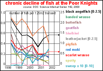
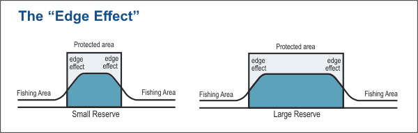
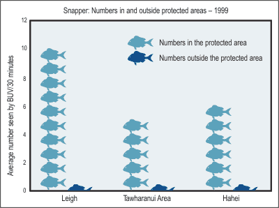
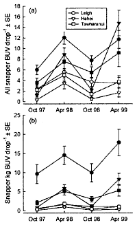
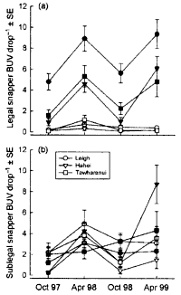
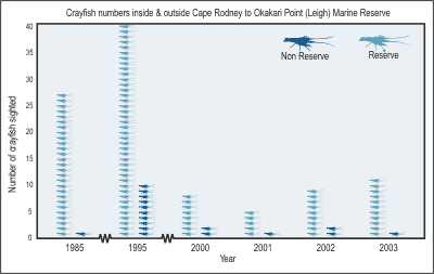
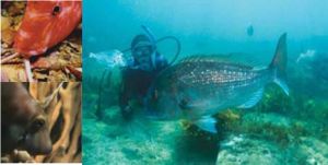
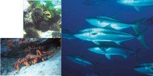
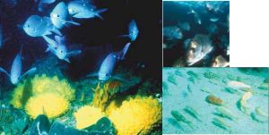
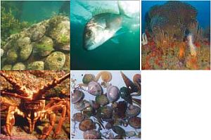
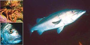
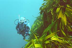
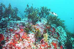
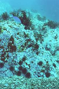
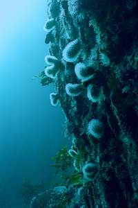
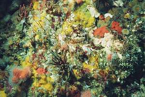
 The area investigated
extends approximately four kilometres offshore and includes significant
areas of reef and soft-bottom habitat beyond the current one kilometre
Marine Park boundary. The proposed boundaries attempt to include all the
major habitats at Mimiwhangata in one reserve. This includes the sand areas
to the north and south of the main deep reef.
The area investigated
extends approximately four kilometres offshore and includes significant
areas of reef and soft-bottom habitat beyond the current one kilometre
Marine Park boundary. The proposed boundaries attempt to include all the
major habitats at Mimiwhangata in one reserve. This includes the sand areas
to the north and south of the main deep reef.