|
|
-- home -- oceanography
index -- site map -- Rev 20000808,20020710,20021018,20030613,20060423,20070719,
Location
 This
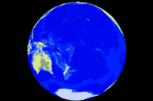
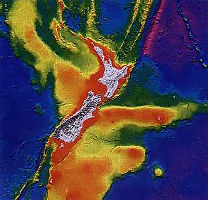
world view of the water hemisphere with the mostly submerged continent
of New Zealand nearest to its centre, shows that New Zealand is more than
any other country on Earth, a sea nation. New Zealand (4 million people)
is located in an area of the world where few people live. Its immediate
surrounding is shared with Antarctica (empty), Australia (18 million people)
and Oceania (very few people). New Zealand is located on the boundary of
two tectonic plates (Indian-Australian and Pacific) that slide past each
other, while also pushing towards each other. The north Island is located
on one part of a shallow continental crust, that extends all the way to
New Caledonia. The South Island is located on a triangular continental
crust, including the Chatham Islands. When leaving Gondwanaland, these
two parts formed the Rangitata land mass, here visible in light blue, running
from NZ to New Caledonia. This
world view of the water hemisphere with the mostly submerged continent
of New Zealand nearest to its centre, shows that New Zealand is more than
any other country on Earth, a sea nation. New Zealand (4 million people)
is located in an area of the world where few people live. Its immediate
surrounding is shared with Antarctica (empty), Australia (18 million people)
and Oceania (very few people). New Zealand is located on the boundary of
two tectonic plates (Indian-Australian and Pacific) that slide past each
other, while also pushing towards each other. The north Island is located
on one part of a shallow continental crust, that extends all the way to
New Caledonia. The South Island is located on a triangular continental
crust, including the Chatham Islands. When leaving Gondwanaland, these
two parts formed the Rangitata land mass, here visible in light blue, running
from NZ to New Caledonia. |
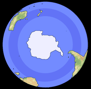
The uniqueness of New Zealand is best illustrated by looking at the globe from the south, as shown in the picture left below. By comparison, a view of Earth from the north is placed beside it. The southern hemisphere has very little life on it. We see South America, Africa and Australia, all three large continents extending into the tropics. Both Africa and South America are large north-south oriented continents spanning many climate zones and habitats. By contrast, New Zealand is the only small continent on the southern hemisphere (notice Madagascar there too). Lying in the middle of the southern temperate climate zone, New Zealand suddenly represents a sizeable part of the entire world.
Note that the south pole can be seen as a continent surrounded by oceans, whereas the north pole as an ocean surrounded by continents. Because of this, these two sides of the planet are, like cheese and chalk, totally different from one another, in oceanography, climate and environment.The little continent of New Zealand (although much of it was submerged for a long time), has existed in isolation for long enough to evolve its own, very special, natural environment. Its native flora and fauna are truly unique in this world. Its many isolated islands have contributed to its diversity in species. Its north-south orientation has prevented species to become extinct due to the ice ages, by allowing them to migrate north during ice ages and south in the warmer periods in-between.
The life forms found in South America, are not found in Africa, although at some time (200 million years ago), these two continents were interconnected. Likewise, Australia has nothing in common with either South America or Africa. New Zealand has none of the species found in either Africa or south America, but we do have a number of species in common with Australia. It appears that those species migrated from Australia to New Zealand, rather than the other way around. Both the winds and the ocean currents lead to New Zealand. It is not surprising therefore, that New Zealand has ended up with a large number of endemic and unique species, that need to be preserved for eternity.
When it comes to sea life, one might easily
think that because all oceans are interconnected, that therefore all sea
life is able to migrate to all sea coasts. Surprisingly, this is not the
case, and New Zealand does not share any marine species with either South
America or South Africa, but we do share a number of species with Australia
and surrounding islands. The reason that marine species cannot migrate
easily across oceans is that only the margins of continents have enough
nutrients to be biologically productive and to provide the food for existence.
Outside these continental fringes, the oceans turn into 'barren deserts',
devoid of food and preventing both mature fish and fish larvae from swimming
across. (Note that some species do migrate very large distances, such as
tuna, swordfish, marine mammals).
New Zealand has a substantial number of endemic marine species in all
phyla (main groups), and many new ones are discovered every year.
 |
 |
Temperature
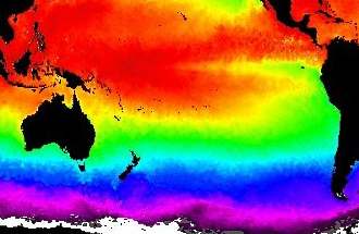 This
map of the South Pacific ocean shows the average temperature of the ocean
as coloured bands. Notice how NZ spans across three different colours,
representing a range of over 6 ºC. Notice also how the cool water
penetrates north along the west coast of South America, due to the coastal
Peru or Humboldt Current running northward. It brings cool, plankton-rich
waters all the way to the tropics where the Galapagos Islands are located.
Conversely, on the western side of the Pacific, the warm water is brought
down by a wide, slow moving current. It passes southward along Australia's
east coast, bringing warm water to New Zealand. For this reason, the temperature
of New Zealand is 2-3ºC warmer than it would have been without. This
map of the South Pacific ocean shows the average temperature of the ocean
as coloured bands. Notice how NZ spans across three different colours,
representing a range of over 6 ºC. Notice also how the cool water
penetrates north along the west coast of South America, due to the coastal
Peru or Humboldt Current running northward. It brings cool, plankton-rich
waters all the way to the tropics where the Galapagos Islands are located.
Conversely, on the western side of the Pacific, the warm water is brought
down by a wide, slow moving current. It passes southward along Australia's
east coast, bringing warm water to New Zealand. For this reason, the temperature
of New Zealand is 2-3ºC warmer than it would have been without. |
 This
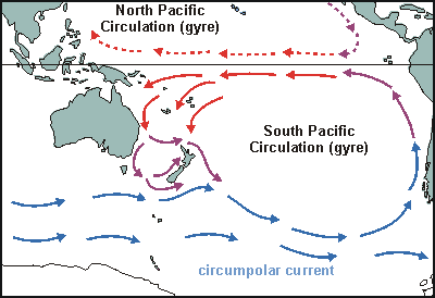
part of the world map shows the most important currents affecting New zealand.
In the south runs the circumpolar current of cold water. It is the only
current running non-stop around the world, which allows it to achieve speed.
Powered by the strongest winds of the world, this current moves fast. As
it gets blocked by the spit of South America, it is deflected northward,
bringing very cold water to its coast. Already rich in nutrients, this
current spirals anti-clockwise along Chile's coast, bringing even more
nutrients to the surface, reason why Chile's fishery is legendary in its
yields. As it warms, this current brings a dry climate. The reverse is
true when the East Australia current cools off over New Zealand, bringing
a moist climate. This
part of the world map shows the most important currents affecting New zealand.
In the south runs the circumpolar current of cold water. It is the only
current running non-stop around the world, which allows it to achieve speed.
Powered by the strongest winds of the world, this current moves fast. As
it gets blocked by the spit of South America, it is deflected northward,
bringing very cold water to its coast. Already rich in nutrients, this
current spirals anti-clockwise along Chile's coast, bringing even more
nutrients to the surface, reason why Chile's fishery is legendary in its
yields. As it warms, this current brings a dry climate. The reverse is
true when the East Australia current cools off over New Zealand, bringing
a moist climate. |
The South Pacific circulation is not constant, but is subjective to
decadal oscillation (IPO= Inter-decadal Pacific Oscillation), resulting
in El Niño/ La Niña periods. This phenomenon will be explained
in detail in a later chapter, but it can be understood from the effect
affecting its cause (like the tail wagging the dog). The dry climate over
Chile causes a high pressure area, and conversely there is a low pressure
area over the Coral Sea. The westward equatorial wind caused by this barometric
pressure difference, drives one arm of the gyre, the South Equatorial Current.
As the current increases, it creates weather patterns that increase its
speed even further. Conversely, once it slows down, it weakens its driving
force, slowing down further still. Eventually it comes to a periodic standstill.
This is the El Niño phase, during which warm tropical water is not
transported southward, amassing instead in the tropics, causing corals
to bleach and the Chilean fishery to collapse. It also causes nuisance
plankton blooms in New Zealand (1983-84, 1992-96, 2002-?).
  This
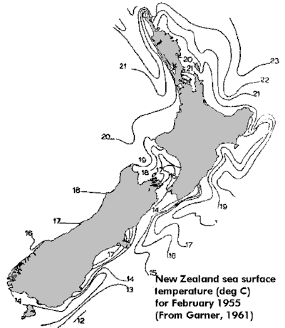
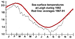
map of seawater surface temperatures, taken in mid-summer of 1955, shows
the typical range from 21ºC in the north to 14ºC in the very
south of New Zealand. The seasonal variation from summer to winter is presented
in the temperature graph for Leigh, north of Auckland. In this year, the
water was very much colder than normal, associated with a strong El Niño
event for that year and the two years following. It led to massive plankton
blooms, resulting in kelpbed death, huge fish mortality and poisoned shellfish. This
map of seawater surface temperatures, taken in mid-summer of 1955, shows
the typical range from 21ºC in the north to 14ºC in the very
south of New Zealand. The seasonal variation from summer to winter is presented
in the temperature graph for Leigh, north of Auckland. In this year, the
water was very much colder than normal, associated with a strong El Niño
event for that year and the two years following. It led to massive plankton
blooms, resulting in kelpbed death, huge fish mortality and poisoned shellfish.
Why this happens, is not clearly understood, but it may be explained from the stagnating Pacific currents. Seawater temperatures drop because much less warm water flows southward from the tropics. Furthermore, the cleansing influence of the currents, which normally transport nutrients away from NZ, has lessened, allowing nutrients to increase their concentrations. The combination of unusual temperatures and high nutrient concentrations then favours unusual planktonic organisms to bloom. Many of these, particularly the ancient dinoflagellates, are poisonous. Higher concentrations of carbondioxide in the atmosphere, could be of influence too. It seems as if the sea conditions of many million years ago recur, favouring the ancient planktonic organisms of that era, organisms which under normal circumstances are not capable of competing with the more recent and more efficient diatoms. |
New Zealand's natural environment
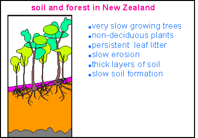 New
Zealand is one of the very few small places on Earth where species evolved
over a long period (80 million years) in total isolation. New Zealand's
'ark' set out on its own long and experimental journey. At the beginning,
NZ's main plants were ferns and conifers. For reasons not readily understood,
the New Zealand native forest developed slow growing, slowly metabolising
species. The podocarps developed from needle leafed species (conifers).
Nearly all NZ plants are non deciduous (do not drop their leaves in winter),
producing persistent, slowly decomposing leaf litter. As a result, the
soils under these forests are thick, which decreases the speed of soil
formation at the bedrock level, which in turn decreases the amount of nutrients
available, which causes the forests to grow slowly. All this has resulted
in a unique situation of low natural erosion, clean rivers and clean seas.
Along the coasts, marine species evolved in the clear seas. Now erosion
rates are over twenty times higher, causing problems to both the land and
the sea. Landcare Research has established recently that New Zealand's
soils erode ten times faster than the world's average! New
Zealand is one of the very few small places on Earth where species evolved
over a long period (80 million years) in total isolation. New Zealand's
'ark' set out on its own long and experimental journey. At the beginning,
NZ's main plants were ferns and conifers. For reasons not readily understood,
the New Zealand native forest developed slow growing, slowly metabolising
species. The podocarps developed from needle leafed species (conifers).
Nearly all NZ plants are non deciduous (do not drop their leaves in winter),
producing persistent, slowly decomposing leaf litter. As a result, the
soils under these forests are thick, which decreases the speed of soil
formation at the bedrock level, which in turn decreases the amount of nutrients
available, which causes the forests to grow slowly. All this has resulted
in a unique situation of low natural erosion, clean rivers and clean seas.
Along the coasts, marine species evolved in the clear seas. Now erosion
rates are over twenty times higher, causing problems to both the land and
the sea. Landcare Research has established recently that New Zealand's
soils erode ten times faster than the world's average! |
When NZ started its lonely journey, mammals did not exist. As a result, NZ does not have native mammals (except for two bat species). NZ must have had its share of dinosaurs, fossils of which have been discovered, but many of these were lizard like. It is thought that the tuatara lizard (Sphenodon punctatus) is still the same as 80 million years ago. Among the profuse bird life, the unique flightless moas evolved, now all extinct.
An important thing to remember is that NZ had very little habitat because
of its small size. So there was not enough room for either a large number
of species or a large number of individuals of each. As a result, most
species here have always existed in numbers, now associated with 'endangered'
status (See the red data book of NZ
on extinct and endangered species). It is no surprise then, that the NZ
natural environment is considered seriously threatened. We have to learn
that the privilege of living here, implies that we also have to live more
carefully than anywhere else on the planet, and that we have to actively
preserve our native heritage. It also means that ways and rules employed
elsewhere will most likely, not be applicable here. We have to see our
country as unique, and manage it in unique ways.
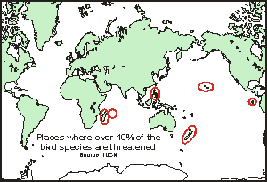 The
IUCN (International Union for the Conservation of Nature) Species Survival
Commission lists NZ with four other countries as the only nations where
more than 10% of bird species is threatened. That puts us in the company
of other very special places on Earth: Galapagos Islands, Hawaii, Philippines,
Madagascar and Mauritius. What these places have in common is that they
had well established wildlife and that they were discovered last.
How could this make a difference? The
IUCN (International Union for the Conservation of Nature) Species Survival
Commission lists NZ with four other countries as the only nations where
more than 10% of bird species is threatened. That puts us in the company
of other very special places on Earth: Galapagos Islands, Hawaii, Philippines,
Madagascar and Mauritius. What these places have in common is that they
had well established wildlife and that they were discovered last.
How could this make a difference? |
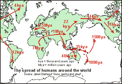 The
answer to the disappearance of species must be found in the spread of the
human race over the planet, as depicted in the map (Source: Jared Diamond,
Guns,
Germs and Steel.). About 7 Mya (million years ago), ape like species
evolved in Africa, that were recognisably no longer apes. It wasn't until
2 Mya that they started to look like present-day humans. The
answer to the disappearance of species must be found in the spread of the
human race over the planet, as depicted in the map (Source: Jared Diamond,
Guns,
Germs and Steel.). About 7 Mya (million years ago), ape like species
evolved in Africa, that were recognisably no longer apes. It wasn't until
2 Mya that they started to look like present-day humans.
About 1Mya they started to migrate north and spread over the 'easy living' areas of the Asian continent. From that period and area stem our domesticated crops (wheat, pulses, etc.) and animals (goat, sheep, cow, horse, etc.). By 0.5 Mya, humans were able to stand the cold of northern Europe (during warm interglacials) and they spread into its rich hunting forests. |
By 45 kya (thousands years ago), most of Indo-China and the Indonesian
archipelago was covered and by 40 kya, during a serious ice age, the 'aborigines'
could walk to Australia and Papua New Guinea. It took the technology of
boats and navigation before the Pacific Islands could be populated, and
from here New Zealand (1000 ya) and Hawaii (500 ya).
The Americas were taken afoot during the onset of a recent ice age,
about 12000 years ago and within 2000 years, both continents of North and
South America had been populated.
Wherever humans appeared, species disappeared. First the large ones
that were easy to hunt and later the smaller ones. New Zealand formed no
exception.
But the main transformation of the land came with large-scale agriculture. It was primitive agriculture that sustained the civilisations of the Incas, the Egyptians, the Greek, the Romans and others, but all these succumbed due to over exploitation of their lands. Soil erosion proved to be their downfall. New Zealand was colonised only some 150 years ago and its lands were cleared for agriculture between 100 and 50 years ago. For every paddock (meadow) created, an identical amount of native habitat disappeared, and with it the native animals and plants. What remained, were the mountainous regions, inhospitable to forestry and agriculture and most native species. Erosion is high and damages the land, the fresh waters and the seas. NZ appears to be in a state of serious degradation of its environment. See also the chapters on soil and erosion and decay.
New Zealand's Exclusive Economic
Zone (EEZ)
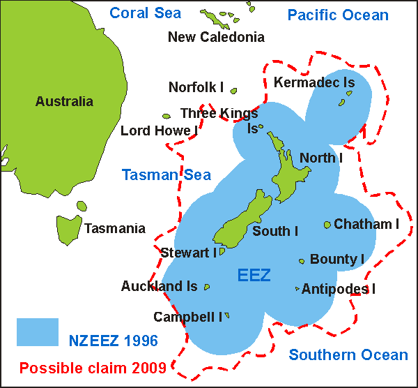
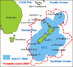 In
1978 the United Nations Conference on the Law Of the Sea (UNCLOS) extended
New Zealand's territorial waters extensively (but NZ didn't ratify it until
1996). Because our outlying islands are located at favourable positions,
the 200 nautical mile (370 km) circles drawn around them and the mainland's
coast, neatly joined up, creating a contiguous sea area of 4.83 million
square km, 15 times larger than the land. With a stroke of the pen, NZ
became the fourth largest maritime country in the world. Only, France &
French Polynesia, USA and Indonesia have larger EEZs. In our EEZ the fishing
is reasonably good, due to currents and upwellings and a large continental
shelf and continental rise (about 30% of the EEZ). (See map
of NZ seabed, courtesy NIWA) (Click
here for a larger
EEZ map). Note that
the area in continental shelf is often more imprtant to fisheries than
the EEZ. It places New Zealand at the bottom of twenty other countries
(see table below). In
1978 the United Nations Conference on the Law Of the Sea (UNCLOS) extended
New Zealand's territorial waters extensively (but NZ didn't ratify it until
1996). Because our outlying islands are located at favourable positions,
the 200 nautical mile (370 km) circles drawn around them and the mainland's
coast, neatly joined up, creating a contiguous sea area of 4.83 million
square km, 15 times larger than the land. With a stroke of the pen, NZ
became the fourth largest maritime country in the world. Only, France &
French Polynesia, USA and Indonesia have larger EEZs. In our EEZ the fishing
is reasonably good, due to currents and upwellings and a large continental
shelf and continental rise (about 30% of the EEZ). (See map
of NZ seabed, courtesy NIWA) (Click
here for a larger
EEZ map). Note that
the area in continental shelf is often more imprtant to fisheries than
the EEZ. It places New Zealand at the bottom of twenty other countries
(see table below). |
Fisheries regulations were changed, resulting in better control over
fish catches and an extensive research programme was started to explore
the newly won seas, resulting in many new discoveries. For example, about
20 new fish species are discovered each year. (See also the chapter on
fisheries)
| Country
France & Fr Polynesia (French Polynesia) United States Indonesia New Zealand Australia USSR Japan Brazil Canada Mexico Papua New Guinea Chile |
Shelf
0.1478 - 1.8707 2.7769 0.2428 2.2692 1.2495 0.4805 0.7686 2.9034 0.4421 ? 0.0274 |
EEZ
10.26 5.03 9.71 5.41 4.83 4.50 4.49 3.86 3.17 2.94 2.85 2.37 2.29 |
The NZ economy
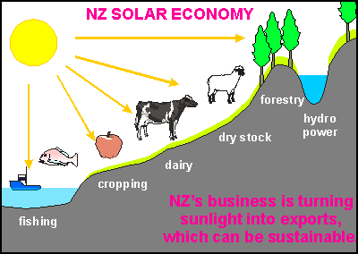 New
Zealand has proved to be poor in minerals but its climate is conducive
to forestry and agriculture. Making best use of its resources, the NZ economy
has developed into a solar economy, in essence turning sunlight into exports.
As sunlight is free, and inexhaustible, the economic basis of the NZ economy
is in principle sustainable. The drawing shows the main components of our
solar economy. New
Zealand has proved to be poor in minerals but its climate is conducive
to forestry and agriculture. Making best use of its resources, the NZ economy
has developed into a solar economy, in essence turning sunlight into exports.
As sunlight is free, and inexhaustible, the economic basis of the NZ economy
is in principle sustainable. The drawing shows the main components of our
solar economy.
The sun shining on the sea, makes plankton grow that feeds the fish.
We catch the fish and export it. The sun makes our crops, dairy cows and
dry stock grow and we export their products: produce, wine, milk, butter,
meat, hides and wool. Where exotic forests have been planted, the sunlight
makes these grow and we export their timbers. Finally sunlight evaporates
water that rains down to fill our hydro lakes, from which drinking water
and electric power are derived.
|
| Provided that we will be able to contain erosion, this kind of an economy has very long-term prospects. It is a pity that successive governments have undermined its solid economical base, often because commodity prices have been temporarily low ('there is no money in agriculture' or 'we are not making what the world wants'). By contrast, all other kinds of activity either do not produce real wealth (finance, banking, tourism, etc.) or they rely on high inputs of energy (manufacturing, transport, etc.) or on high levels of importing. Very recently the 'knowledge economy' is being toted as NZ's solution to more welfare, but in order to have knowledge related jobs, there must be industries requiring this knowledge. New Zealand's ultimate disadvantage is being so remote. It is not located on a junction of trading routes (like Hong Kong, Singapore, etc.) and it does not have a large population to support industry. |
|
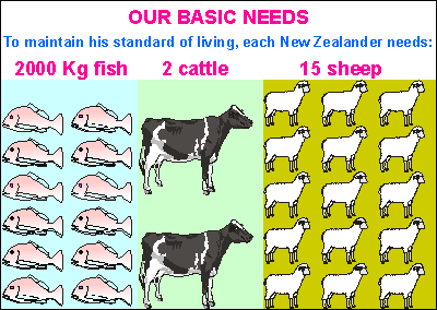 Not
many nations depend on agriculture as much as New Zealand does. The picture
shows by how much every New Zealander depends on the solar economy: 15
sheep, 2 cows and 2 tonnes of fish are required for each inhabitant in
order to maintain his standard of living. This is the standing stock on
land and in the sea, but we harvest only part of it each year: about 40%
of the sheep, 20% of the cattle and cows and less than 10% of the fish.
We eat only very little of this food and manage to sell most overseas.
From this revenue we import the items we cannot manufacture here. A large
proportion of that is fossil fuel and interest on foreign owned capital.
Since the 1980s, successive governments have tried in vain to improve how
we pay our way in the world. A belief has taken hold that only unhindered
competition in free markets can deliver what society needs, leaving no
room for prudence, insight, contingency and common sense. But their policies,
sold as 'export-led sustainable economic growth', and which should have
been directed at improving exports and local investment, while discouraging
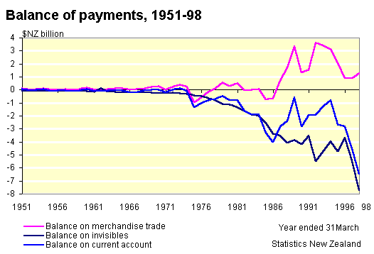
imports, have achieved exactly the opposite. In 1998, NZ had a current
account deficit of 6.5 G$ (billion dollar) against export receipts of 21.7
G$. Overseas debt stood at 20 G$ (Government) + 79 G$ (business)
= 99 G$ total, or about $25,000 per capita, increasing at the rate of about
$2000 per capita per year! In 2005 the total overseas debt stood at 120G$
and the current account deficit at 12G$. One does not need to be a mathematical
genius to see that this is far from sustainable. Click here for a graph
of NZ's current account deficit. (Source:
Statistics New Zealand) Not
many nations depend on agriculture as much as New Zealand does. The picture
shows by how much every New Zealander depends on the solar economy: 15
sheep, 2 cows and 2 tonnes of fish are required for each inhabitant in
order to maintain his standard of living. This is the standing stock on
land and in the sea, but we harvest only part of it each year: about 40%
of the sheep, 20% of the cattle and cows and less than 10% of the fish.
We eat only very little of this food and manage to sell most overseas.
From this revenue we import the items we cannot manufacture here. A large
proportion of that is fossil fuel and interest on foreign owned capital.
Since the 1980s, successive governments have tried in vain to improve how
we pay our way in the world. A belief has taken hold that only unhindered
competition in free markets can deliver what society needs, leaving no
room for prudence, insight, contingency and common sense. But their policies,
sold as 'export-led sustainable economic growth', and which should have
been directed at improving exports and local investment, while discouraging
imports, have achieved exactly the opposite. In 1998, NZ had a current
account deficit of 6.5 G$ (billion dollar) against export receipts of 21.7
G$. Overseas debt stood at 20 G$ (Government) + 79 G$ (business)
= 99 G$ total, or about $25,000 per capita, increasing at the rate of about
$2000 per capita per year! In 2005 the total overseas debt stood at 120G$
and the current account deficit at 12G$. One does not need to be a mathematical
genius to see that this is far from sustainable. Click here for a graph
of NZ's current account deficit. (Source:
Statistics New Zealand) |
| Environmental Problems
Some of this country's environmental problems have been mentioned above. New Zealand is a sparsely populated country, 'green and clean' as it is known overseas. Yet, why do we have similar problems as much more populated areas and almost in the same amounts? In recent years we have been alarmed by degrading land, declining fish stocks, poisoned shellfish, mass fish mortalities, disappearing species and more. How is that possible for a nation with fewer than 4 million people and located so far away from the industrial world? |
|
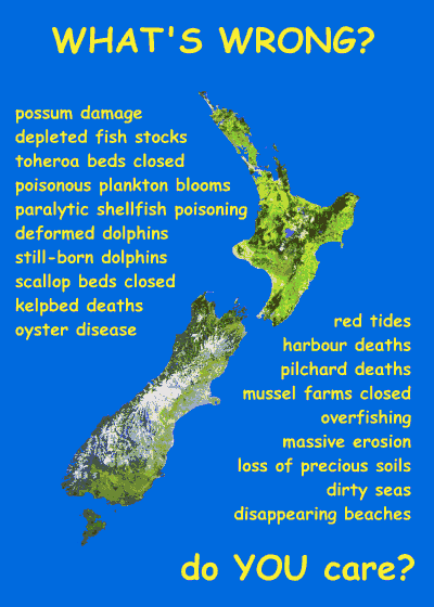
The answer must be sought in our solar economy. We are sharing our land with 55 million sheep and 8 million cows. Although they live on the land, they nonetheless produce wastes. On good, ecologically farmed land, these wastes should cycle on and in the soil, leaching only small amounts of nutrients into waterways and ultimately the sea. But our farmland is not managed well, mainly through ignorance (see chapters on soil sustainability and erosion). Far more (over 20 times) effluent and fertiliser reaches our coastal seas than is natural (before the discovery of NZ). A grazing animal cycles a lot of grass in order to produce one kg of meat, so a little amount of leaching during each cycle, adds up to a large amount in total. An estimate of the amount of waste effluent produced by our ruminants, establishes an equivalent of 150-200 million people for our grazing herds. No surprise then that our environmental problems are in the same league as China's. Click on the poster to see a larger one with our coastal problems. |
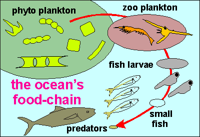 Together with human wastes (which are not recycled at all), the combined
nutrients fertilise our coastal seas, causing the phyto plankton to bloom.
In itself, this is beneficial, since zoo plankton will feed from the phyto
plankton, feeding small fishes, and eventually the larger fish that we
catch in our fisheries. It is a process no different from feeding pot plants
with fertiliser. If this is omitted, the plant will stunt and die. But
when fertilised too much, the plant will also wither and die. Nature has
an optimal rate for most processes. So too for the amount of nutrients
that is beneficial to our seas. When the sea becomes too rich, it reacts
by producing poisonous plankton blooms. It is called eutrophication. (Gk
eu
= well, trepho = nourish; overnourished). It is no surprise
that nearly all of our problems are experienced in our coastal waters.
Together with human wastes (which are not recycled at all), the combined
nutrients fertilise our coastal seas, causing the phyto plankton to bloom.
In itself, this is beneficial, since zoo plankton will feed from the phyto
plankton, feeding small fishes, and eventually the larger fish that we
catch in our fisheries. It is a process no different from feeding pot plants
with fertiliser. If this is omitted, the plant will stunt and die. But
when fertilised too much, the plant will also wither and die. Nature has
an optimal rate for most processes. So too for the amount of nutrients
that is beneficial to our seas. When the sea becomes too rich, it reacts
by producing poisonous plankton blooms. It is called eutrophication. (Gk
eu
= well, trepho = nourish; overnourished). It is no surprise
that nearly all of our problems are experienced in our coastal waters.
Read about our latest discoveries about eutrophication and how it kills sea life. |
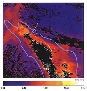 The
satellite image shown here (courtesy of NIWA), maps chlorophyll concentration
from measurements of the colour of the surface of the sea. The area covered
extends from Auckland northward (Northland). The chlorophyll density scale
(colouring) is rather deceptive, running over more than 4 orders of magnitude
from 0.01 to almost 100 mg/m3. Also shown in a blue curve, is the contour
of the continental shelf. The
satellite image shown here (courtesy of NIWA), maps chlorophyll concentration
from measurements of the colour of the surface of the sea. The area covered
extends from Auckland northward (Northland). The chlorophyll density scale
(colouring) is rather deceptive, running over more than 4 orders of magnitude
from 0.01 to almost 100 mg/m3. Also shown in a blue curve, is the contour
of the continental shelf.
Chlorophyll (Gk chloro = green ; phyllon = leaf) is the green enzyme that enables plants to assimilate carbondioxide and oxygen into carbohydrates and other molecules of life, so it is an indication of the amount of life in primary production (which may not be exactly the same as productivity). Blue areas lack nutrients and can be considered the equivalent of a desert. Where the chlorophyll scale goes from yellow to white, the chlorophyll level is a thousand times higher, creating conditions favouring poisonous plankton species and decomposing bacteria. (Note that the conditions for poisonous plankton blooms are not sufficiently known, but overnourishing appears to be important.) |
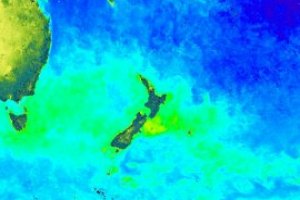 This
map shows average chlorophyll concentrations around NZ, indicating that
they are highest above the continental shelf. It also shows that a sizable
component arrives from Australia, and that a large part of the Tasman Sea
is fertilised from Australia's coastal waters. Notice that the blue areas
are almost devoid of life (ocean deserts). Along the west coast of NZ,
prevailing westerly winds push the plankton-rich surface waters onto the
coast. Otherwise, it appears that nutrients and plankton are kept within
the boundaries of the continental shelves, where it feeds our coastal fisheries.
Note that the areas with the highest chlorophyll concentrations (picture
above), co-incide with the places where shellfish poisoning has been found
and the fisheries closed at times. People appear to accept the new threats
to our seas as just another fact of life, but in this web site, we'll pursue
the questions necessary to save our seas, further. This
map shows average chlorophyll concentrations around NZ, indicating that
they are highest above the continental shelf. It also shows that a sizable
component arrives from Australia, and that a large part of the Tasman Sea
is fertilised from Australia's coastal waters. Notice that the blue areas
are almost devoid of life (ocean deserts). Along the west coast of NZ,
prevailing westerly winds push the plankton-rich surface waters onto the
coast. Otherwise, it appears that nutrients and plankton are kept within
the boundaries of the continental shelves, where it feeds our coastal fisheries.
Note that the areas with the highest chlorophyll concentrations (picture
above), co-incide with the places where shellfish poisoning has been found
and the fisheries closed at times. People appear to accept the new threats
to our seas as just another fact of life, but in this web site, we'll pursue
the questions necessary to save our seas, further. |
Currents
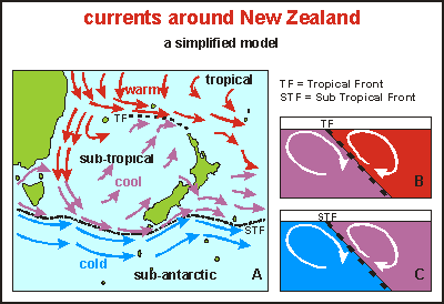 This
map shows the principles behind the currents found around New Zealand and
in the Tasman Sea. The South Equatorial Current (far north of this map),
which is very warm as it reaches Australia's east coast, is bent southward
by Coriolis forces and by this coast. At Australia's easternmost point,
it splits and one part veers east, deflected by Coriolis forces. The other
half follows the east coast down until it meets cool water passing around
Tasmania. On its way south, it meets the cold water of the West Wind Drift
and a front or convergence forms because water masses of different temperature
and salinity, mix with difficulty. In diagrams B and C, such a front is
shown in a very simplified way. The front acts as a wall between the two
currents that spiral along it at either side. The STF effectively walls
the Tasman Sea in. Water entering it from the north, cannot pass this wall
and has to exit somewhere east of New Zealand, passing by Stewart Island,
through Cook Strait and around North Cape. This
map shows the principles behind the currents found around New Zealand and
in the Tasman Sea. The South Equatorial Current (far north of this map),
which is very warm as it reaches Australia's east coast, is bent southward
by Coriolis forces and by this coast. At Australia's easternmost point,
it splits and one part veers east, deflected by Coriolis forces. The other
half follows the east coast down until it meets cool water passing around
Tasmania. On its way south, it meets the cold water of the West Wind Drift
and a front or convergence forms because water masses of different temperature
and salinity, mix with difficulty. In diagrams B and C, such a front is
shown in a very simplified way. The front acts as a wall between the two
currents that spiral along it at either side. The STF effectively walls
the Tasman Sea in. Water entering it from the north, cannot pass this wall
and has to exit somewhere east of New Zealand, passing by Stewart Island,
through Cook Strait and around North Cape. |
During the interaction along a convergence, nutrients are circulated to the surface, inviting for rich plankton blooms and fish production. At New Zealand's southernmost tip (Stewart Island), this cool current splits and the Subtropical Front passes very close to the shore, only to veer east again over the Chatham Rise in the direction of the Chatham Islands.
Deflected by Coriolis forces, cool water flows slowly north in the 'walled-off' Tasman Sea, to meet the warm water coming from the tropics. Again a front (Tropical Front) or convergence is formed between the two water masses, as shown in diagram B. The cool water pushes this front far enough north to concentrate a strong current over the northernmost tip of New Zealand. This East Auckland Current consists of both cool and warm water. Some of it flows eastward but enough remains to flow along the east coast of the North Island, at some 50-200 km offshore. The map below shows the most recent discoveries about the currents around New Zealand.
Note that in the above map and diagrams, and in fact in all current
maps of the oceans, average water flows are shown. In reality currents
consist of plumes spearheading forward, flanked by eddies. Eddies can separate
themselves and live for a while as walled-in circulating basins. In the
front cross-sections B and C, it is not shown that temperature decreases
with depth on both sides of the front. At some depth (100-300m), temperatures
become equal and the front disappears.
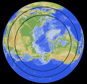
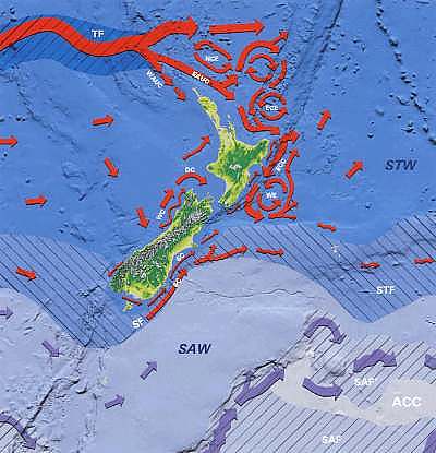 This
map (Courtesy NIWA) shows the currents around New Zealand as they have
been mapped by NIWA. Much research needs to be conducted to map the missing
bits. Outside the southern end of the map one finds arctic water, as cold
as it can get (1-2 degrees). Above it and showing as SAF is the Sub-Antarctic
Front, marking a slight temperature gradient towards the Sub-Antarctic
Water (SAW) of 2-6 degrees. At the bottom of the map runs the West Wind
Drift from west to east. This
map (Courtesy NIWA) shows the currents around New Zealand as they have
been mapped by NIWA. Much research needs to be conducted to map the missing
bits. Outside the southern end of the map one finds arctic water, as cold
as it can get (1-2 degrees). Above it and showing as SAF is the Sub-Antarctic
Front, marking a slight temperature gradient towards the Sub-Antarctic
Water (SAW) of 2-6 degrees. At the bottom of the map runs the West Wind
Drift from west to east.
The dark blue area belongs to Sub Tropical Water (STW) of 8-20 degrees, surrounding all of New Zealand, and bounded by the Sub Tropical Front (STF) down south and the Tropical Front (TF) up north. The main current arriving from Australia is the East Australia current flowing eastward along the Tropical Front. It splits into an East Auckland Current (EAUC), and a larger part that passes much further away. A number of permanent eddies have been discovered to the north and north-east. |
The effects these currents have on New Zealand are:
-- home -- oceanography
--