,
Are marine reserves working? summaries of publications concerned about environmental effects Compiled by Dr J Floor Anthoni
www.seafriends.org.nz/issues/war/worknot.htm
Gradually marine scientists all over the world
begin to realise that marine reserves cannot work in seas where other threats
remain, like pollution from the land. They also question the merit of a
reserve that cannot be managed to reach its objectives. This page contains
summaries of relevant articles from the international literature. Any environment
that degrades is unsustainable.
Habitat degradation and
the future of fish assemblages on temperate and tropical reefs G.P. JONES (1993)
School of Marine Biology and Aquaculture, James Cook University, Townsville,
4811, Queensland, Australia.
This abstract can be found as a PDF file in: http://www.icef.eawag.ch/abstracts/jones.pdf
Background Human impacts on temperate kelp forests and tropical coral reefs continue
to cause dramatic changes to the biotic structure of these habitats (e.g.,
McClanahan and Muthiga 1988, Jones et al., 1993, Hughes 1994, Steneck and
Carlton 2001). However, few have examined the consequences of declining
kelp and coral cover for the biodiversity of mobile organisms using these
habitats.
Aim In this paper, reef-associated fishes are used as an indicator of the
ecological price that the habitat-user pays for habitat degradation. While
there are some fishes that play key top-down roles in both kelp forest
and coral reef habitats, by far the greatest biodiversity of fish species
are likely to be influenced from the bottom-up.
Results There are striking parallels between temperate and tropical reefs in
fish-habitat interactions. In both kelp forest and coral reef systems,
different biotic habitats are always associated with recognizably different
fish communities. In both systems, greater fish biodiversity is always
associated with habitats of greater complexity. Habitat degradation results
in deterministic changes to the structure of fish communities, regardless
of whether they are caused by global warming, pollution, or the exploitation
or introduction of keystone predators, grazers (urchins, crown-of-thorns)
or habitat-forming organisms (kelp, corals). Moderate disturbance to habitats
is likely to be an important process that maintains fish species diversity,
because it creates patchiness and promotes spatial heterogeneity. However,
chronic or severe disturbance establishes homogeneous habitats that are
the end point of a phase shift from one habitat type to another. Inevitably,
this results in a decline in fish biodiversity through local extinction.
Unless these shallow water ecosystems are effectively managed, the
following predictions can be made. Local extinctions will progress through
regional extinction to global extinctions as the scale of human disturbance
increases. The fish species most threatened are those with specialized
habitat requirements and those with small geographic ranges. It is estimated
that the extirpation of corals in tropical Australia would result in
the regional extinction of obligate coral specialists (10- 15% of reef
fish species). However, most tropical fishes have some resilience to global
extinction because of their large geographic ranges. A lower proportion
of fishes in temperate Australian kelp-forests are likely to be affected
by loss of kelp, as there are relatively few kelp specialists (<5% of
species). However, specialists on temperate reefs are at a greater risk
of global extinction because of their relatively small geographic ranges.
Conclusions Clearly, human impacts on habitat-forming organisms (kelp, corals)
and key habitat-drivers (urchins, starfish) must be ameliorated if fish
biodiversity is to be maintained. Marine reserves have proven to be an
effective tool in re-establishing natural habitat dynamics, where exploitation
has proven to be the key human impact. However, marine reserves alone do
not work when habitat changes are driven extrinsic processes that do not
recognize reserve boundaries. No reef fish has or is likely to be exploited
to extinction. Global warming represents the greatest threat to reef fishes,
because it is the most efficient at destroying habitat-forming organisms
(e.g., coral bleaching, kelp disease) and can modify the aquatic environment
over large spatial scales.
References Hughes, T.P. (1994) Catastrophes, phase shifts, and large-scale degradation
of a Caribbean coral reef. Science. 265, 1547-1551.
Jones, G.P., R. Cole and C. N. Battershill (1993) Marine Reserves:
Do they work? In: The Ecology of Temperate Reefs: Proceedings of the Second
International Temperate Reef Symposium, Auckland, pp. 29-45. NIWA Publications,
Wellington.
McClanahan, T.R. and Muthiga, N.A. (1988) Changes in Kenyan coral reef
community structure and function due to exploitation. Hydrobiologia. 166,
269-276.
Steneck, R.S. and Carlton, J.T. (2001) Human alterations of marine
communities. Students beware! In: Marine community ecology (Bertness,
M., Gaines, S. & Hay, M. eds.), pp. 445-468.
The great majority of marine protected areas
(MPAs) fail to meet their management objectives. The authors
recommend a radically different approach for MPAs to be effective conservation
tools. Firstly they should be located in areas
free from uncontrollable stressors that degrade the environment.
Secondly they should be managed with a view of achieving their objectives
within the budget provided. This should be considered beforehand and assessed
regularly.
It is like having a submarine with screen doors rather than watertight
hatches. Even the slightest screen door will sink the submarine. Likewise
uncontrollable degradation from air, land and oceanic sources will sink
the marine reserve's effectiveness.
Of the 1306 MPAs surveyed by Kelleher et al
(1995) only 31% were achieving their objectives. Obviously we should not
call an area 'protected' when it is not.
The three screen doors recognised by the author are:
Atmospheric
Blown dust carrying herbicides, pesticides, bacteria, viruses,
fungi, nutrients, polyaromatic hydrocarbons, carcinogens and heavy metals.
Climate change: warmer seas, higher levels, increased CO2 absorption,
More severe weather events increasing
sediments, nutrients and storm damage.
Changes in ocean circulation affecting dispersal and transport
of larvae and nutrients.
Tidal exchange: nutrients and turbid water.
Ocean current exchange: pollutants from distant rivers and farmlands
Oceanic upwelling: nutrients
For successful management the level of community (co-operation, presence)
and institutional (laws, regulation, policing) capacity should be assessed
beforehand:
to help clarify the true extent of MPA resources that are manageable.
to make it harder for governments to use MPAs
as underfunded token conservation efforts and to avoid mitigating
more significant environmental threats (e.g. overfishing, climate change,
nitrification, sedimentation) because these are not mitigated by marine
reserves.
to identify the linkages between economic and environmental processes which
are capable of delivering value.
to assist those battling for clean air, land and
water worldwide by injecting a strong dose of reality into the
development vs conservation debate.
The authors then argue for adopting business planning and management techniques
in order to make happen what is intended.
Kelleher G, Bleakley C, Wells S. 1995: Global representative
system of marine protected areas. The World Bank, Washington. 4 vols.
Concerns from Environment Australia http://www.ea.gov.au/coasts/pollution/reef/index.html
The Great Barrier Reef is facing an increasing threat from a decline
in the water quality in the catchments draining into the Reef lagoon. The
Commonwealth and Queensland Governments have agreed, through a Memorandum
of Understanding to jointly developing a Reef Water Quality Protection
Plan to protect the Reef from land based sources of pollution
.
Studies undertaken to support the Plan include a review by a panel
of scientists formed to provide advice on water quality in and adjacent
to the Great Barrier Reef and a Productivity Commission study on industries
in the Great Barrier Reef Catchment and measures to address declining water
quality.
Comments are sought on the Draft Reef Water Quality Protection Plan from
all members of the public and interested stakeholders. The feedback form
is available from the Queensland Government web site.
The Panel found that there are clear indications that major land use
practices in the Reef catchment have led to accelerated erosion and greatly
increased the delivery of nutrients over pre 1850 levels. The reasons
for this decline are varied but relate to activities within the river catchments,
such as the extensive grazing practices in the drier catchments and overgrazing
in general, urban development, agricultural production, water use practices,
extensive vegetation clearing and wetland drainage on coastal plains and
development on acid sulphate soils.
The Panel found that there is clear evidence of the effect of these
practices on some rivers, estuaries and inshore areas. Reefs at a number
of inshore locations along the coast have been disturbed and have remained
in a disturbed state. These reefs exhibit characteristics consistent with
altered ecological function due to enhanced nutrient availability or sedimentation.
Evidence of impacts on offshore areas of the Reef is not well understood,
however information from overseas shows that by the time such effects are
obvious the system would be almost irreparably damaged. In light of the
above factors the Panel confirmed that there is a serious risk to the long
term future of at least the inshore reef area and that action is necessary
to avoid such damage.
The Panel believes that an integrated resource management (ICM) approach
to dealing with the issue is the best approach and supports the concepts
of risk assessment and target setting. To this end the Panel found that
the GBRMPA Action Plan has value on a broad basis, but requires significant
refinement, particularly at a sub-catchment level. The future development
of water quality targets and risk classification must include community
input and are best achieved through existing regional structures using
specific local water quality data.
Unfortunately the Panel embraces unproved
methods of risk assessment and target setting, rather than getting on with
reducing sediment runoff from all the sources mentioned in the frist paragraph.
The deep oceans contain a vast diversity of life forms, many of which
are still being discovered. Some scientists estimate that over 100 million
species may inhabit the high seas. What happened
to the TOTAL number of species on this planet, estimated at 5-14 million?
This
marine life is little understood, and scientific knowledge to guide management
is very limited. There are many examples of severe, and potentially irreversible,
damage to the biodiversity and environment of the high seas under present
management and jurisdictional arrangements.
Please
specify because the seas are the least threatened environments on Earth.
Bioodiversity is about viable populations of all species, not necessarily
about pristine populations.
In order to work towards addressing these issues, Australia will host
a major international conference on high seas biodiversity from 16-20 June
2003. Workshop on Ecosystem Based Management (EBM) - "Beyond
Biodiversity - Sustainable Management and Conservation of the Oceans using
EBM". Marine Pollution from Land-based Sources
By far the greatest sources of marine pollution are those that are
land-based. For both pollution mitigation purposes and the conservation
of marine biodiversity it is critical that international efforts to
address land based sources of marine pollution are accelerated. In
answer to this pressing need and as a result of Agenda 21, the Global Program
of Action for the Protection of the Marine Environment from Land-Based
Activities (GPA) was adopted by over 100 governments, including Australia,
in Washington D.C. on 3 November 1995.
The GPA is a non-legally binding instrument, aimed at preventing the
degradation of the marine environment from land-based activities by facilitating
the realisation of the duty of States to preserve and protect the marine
environment. The sources of marine pollution it targets include sewage,
persistent organic pollutants, radioactivity, metals, oils, nutrients,
sediment mobilisation, litter and habitat destruction. It proposes
action at primarily the national and regional levels with some coordination
tasks at the global level. The GPA is designed to be a source of practical
guidance to States in taking actions within their respective policies,
priorities and resources.
Australia has been an active participant in meetings to discuss the
development, implementation and review of the GPA.
The GPA in Australia. http://www.gpa.unep.org
.
http://www.gpa.unep.org/about/default.htm
Document explaining the rationale for GPA, a Dutch initiative. This document
can now be found on the Seafriends website: /issues/cons/gpa.htm.
More than half of the coral in western Florida Bay, north of the Florida
Keys was destroyed in the past 12 months, and
researchers who've been monitoring Keys coral since 1996 say the black
water event from last spring is to blame. "I'm sure that's what caused
it," said James Porter, a leading coral expert who heads the research team.
"It's something to do with the water chemistry, but it's beyond anything
we know about."
Porter said his team of researchers measured a 60 percent loss of over
one year, "which is the highest rate of loss we have ever seen anywhere
in the Florida Keys in a single year," he said. "Even Hurricane Georges
did not do this kind of damage."
Five coral species were completely wiped out in areas Porter monitors
in the bay, a an area of patch reefs north of the lower third of the island
chain. He noted the demise of centuries-old boulder corals, and large numbers
of other bottom dwellers such as sea squirts, sea biscuits and sponges.
Joining Porter in his assessment of the area's sea life is marine collector
Ken Nedimyer. "Most of the brain corals in the Northwest Channel are dead,"
Nedimyer said. "I could go on. The Middle and upper Keys look good, but
the Lower Keys and Key West were hammered. But we're not supposed to worry
because this is a natural phenomenon."
Officials in the spring characterized the event as naturally occurring
and similar to a 100 years flood. No assessment is yet in on the area hundreds
of square miles in size and farther north where satellite pictures showed
the water pooled for months beginning in November 2001 and then washed
over the Keys.
New concerns
What worries some environmentalists and others along the Southwest Florida
coast is the appearance in recent weeks of another mass of black water
that formed off Sanibel Island near where the Caloosahatchee River an
outlet for Lake Okeechobee empties into the Gulf of Mexico. Jim Anderson,
a Sanibel pilot, said he at first thought the water was oil. Others who
live along the Caloosahatchee River say they've seen a drop in water quality
there over recent weeks.
"I noticed when waves come on shore, the water is thick and black,"
said Mitrah Bakhtian, who's lived along the river for seven
years. Satellite pictures show a cloud of dark water hugging the Florida
coast and concentrating south of Cape Romano, though this water mass isn't
as large as the one in the spring.
"The images are a bit similar to what we saw in the winter black water
event, but they are less dark and appear more brownish and they cover less
(area) and are closer to the coast," said Chuanmin Hu, a researcher at
the University of South Florida's Institute for Marine Remote Sensing.
"This may or may not be the same thing we observed in the winter."
Hu checked the satellite data after hearing reports of black water,
but he said there is no ongoing monitoring and interpreting program in
place.
Scott Willis, spokesman for the Florida Marine Research Institute, said
scientists are collecting water samples from the current mass of water
and will be looking at those this week. Fishermen spotted the first event
in January when it had become a mass bigger than Lake Okeechobee occupying
the area between Cape Romano and the Florida Keys. It slowly moved south
across the Keys by April.
Satellite
pictures at the time showed the water had trailed along the west coast
of Florida from the Caloosahatchee and intensified when it reached western
Florida Bay off the Shark River just below Marco Island and Naples. Researchers
concluded later that the black water was a complex interaction among red
tide and other algae blooms mixing with river runoff, said Beverly Roberts
of FMRI. Few in the scientific community would say if they think July's
dark water is a repeat event, and Roberts said it could just as likely
be normal river runoff. Fresh water is much darker than sea water and would
float along the surface of the gulf. "That can extend miles into the gulf,"
she said.
More than 60 percent of our coastal rivers and bays are moderately
to severely degraded by nutrient runoff. This runoff creates harmful
algal blooms and leads to the degradation or loss of seagrass and kelp
beds as well as coral reefs that are important spawning and nursery grounds
for fish. Each summer, nutrient pollution creates a dead zone the size
of Massachusetts in the Gulf of Mexico. These types of problems occur in
almost every coastal state and the trends are not favorable. If current
practices continue, nitrogen inputs to U.S. coastal waters in 2030 may
be as much as 30 percent higher than at present and more than twice what
they were in 1960.
This ignores the natural nutrients released
from mud entering the ocean, constituting a much larger problem. It also
ignores sedimentation which suffocates marine organisms while reducing
water clarity. Scientists have not caught up with the seriousness and pervasiveness
of the situation.
Long-Term Region-Wide
Declines in Caribbean Corals Toby A. Gardner, Isabelle M. Côté, Jennifer A. Gill, Alastair
Grant, Andrew R. Watkinson
Copyright Science Magazine, 17 July 2003
We report a massive region-wide decline of corals across the entire
Caribbean basin, with the average hard coral cover on reefs being reduced
by 80%, from about 50% to 10% cover, in three decades. Our meta-analysis
shows that patterns of change in coral cover are variable across time periods
but largely consistent across subregions, suggesting that local causes
have operated with some degree of synchrony on a region-wide scale. Although
the rate of coral loss has slowed in the past decade compared to the 1980s,
significant declines are persisting. The ability of Caribbean coral reefs
to cope with future local and global environmental change may be irretrievably
compromised.
Baltic Sea Fish Kill
Blamed on Nutrient Runoff BRUSSELS, Belgium, September 18, 2003 (ENS)
The dramatic loss of marine wildlife recorded last year in the Western
Baltic Sea between Denmark, Germany and Sweden is largely the result of
extreme weather conditions and an increase in nutrients resulting from
human activities, according to the findings of a new report released by
the Helsinki Commission (HELCOM).
Last fall, HELCOM and European Commission joined forces to investigate
exceptional oxygen depletion in the Western Baltic that had led to hundreds
of dead fish being washed ashore along the east coast of Jutland, Denmark.
Widespread and long lasting severe oxygen depletion was observed in
the Kattegat, the Sound and the Baltic Sea in late summer and autumn 2002,
some of the worst ever recorded.
In several areas, extreme oxygen deficiency led to the release of highly
toxic hydrogen sulfide from marine sediments. As a result, creatures living
near the bottom of the sea died and, in October 2002, the Jutland coast
was littered with fish carcasses.
Algae bloom in the Baltic Sea due to eutrophication (Photo courtesy
Helskinki Commission)
The report reveals that the oxygen deficiency was caused in part by
heavy rain and snow, leading to the runoff of higher than usual levels
of nutrients from agriculture, urban wastewater and air pollution into
the sea.
In addition, low wind levels and high air pressure minimized exchanges
between different water levels in the Baltic. The report recommends stricter
controls on nutrients reaching this inland sea to prevent future oxygen
depletion.
In the European Union, intensive agricultural methods make farmland
a major source of waterborne nutrient pollution.
Research Commissioner Philippe Busquin said, We must do more to reduce
the level of man-made nutrients polluting the Baltic Sea and the destruction
of its precious ecology. We cannot ignore nature's alarm calls, and must
ensure that our research findings help shape appropriate international
policies.
The Baltic Sea is ecologically unique, being generally shallow and almost
stagnant, the Commission explains. It is dominated by a substantial input
of freshwater from many rivers and as well as rain and snow, and by the
limited exchange of more saline water over the shallow entrances to the
North Sea.
Scientists have found that the Baltic is particularly sensitive to the
impact of pollution and overexploitation. It is also under pressure from
the housing, agriculture, industry, traffic, energy generation, fishery
and shipping needs of over 85 million people within its large drainage
area.
A preliminary version of the Helsinki Commission report was used in
the preparatory work for the HELCOM Ministerial Meeting, which took place
on June 25 in Bremen, Germany. Environment Commissioner Margot Wallstrom
participated at this meeting where a package of measures for the protection
of the Baltic marine environment was agreed.
The ministers agreed to make agriculture more environmentally sustainable
by improving agricultural practices to ensure efficient use of nutrients
while minimizing any adverse impact on the environment.
European Union laws such as the Nitrate and Urban Waste Water Directives
must be fully implemented, the ministers agreed.
Following the initiative of the HELCOM Monitoring and Assessment Group,
an expert group was set up with Denmark, Germany, Sweden and the European
Commission to analyze the development and causes of this situation using
information gathered from marine biology, oceanography, and satellite remote
monitoring.
Heike Herata chairs the HELCOM Monitoring and Assessment Group (Photo
courtesy HELCOM)
The experts found that eutrophication, a condition in which the waters
are extremely rich in nutrients such as fertilizer components, is still
a major problem in the Baltic Sea.
The symptomatic problems of eutrophication include serious oxygen deficiency,
extensive algal blooms and floating mats of decaying seaweed in coastal
waters. The condition is still common, in spite of substantial efforts
to reduce nutrient inputs over a wide area.
Comparisons between recent years marked by specific weather events in
the area revealed the key roles of snow, rain, and wind and air pressure
in the oxygen balance of marine bottom waters.
The amount of snow and rain controls the nutrient loading of surrounding
rivers by soil erosion. Unseasonably late rains, combined with sunlight
can also indirectly enhance marine plant production in surface waters,
the expert group said. Wind and air pressure acts on the local supply of
oxygen through water exchanges with the oxygen rich waters of the Skagerrak.
While weather conditions were the main trigger of the 2002 event, investigations
revealed that the Baltic Sea is particularly vulnerable to oxygen depletion.
Permanent separation of water strata, minimal reaction with the sea bottom,
restricted flow patterns resulting from semi-enclosed bays and estuaries
and shallow bowl shapes in the sea bottom all favour the isolation of bottom
water masses and therefore limit reoxygenation, the scientists said.
The Baltic Sea region is one of the most naturally sensitive to oxygen
deficiency in Europe. Some confined regions such as the Little Belt were
already experiencing oxygen deficiencies 100 years ago, when nutrient discharges
were relatively low. For several decades the main original cause of extended
oxygen deficiency has been the nutrient supply in surface marine waters.
The Commission contribution indicates that the Belt Sea area has a very
limited capacity to digest the organic matter and, indirectly, to assimilate
any additional supply of nutrients. Further efforts are necessary to meet
the 50 percent nutrient reduction target set by HELCOM.
But, the Commission said, even this might turn out to be insufficient
to drastically reduce the likelihood of severe oxygen depletion in terms
of geographical coverage and duration in the Western Baltic.
HELCOM is the governing body of the Convention on the Protection of
the Marine Environment of the Baltic Sea Area, known as the Helsinki Convention,
originally signed in 1974. Through intergovernmental co-operation between
all the countries bordering the Baltic - Denmark, Estonia, Finland, Germany,
Latvia, Lithuania, Poland, Russia and Sweden - and the EU, HELCOM works
to protect the marine environment from all sources of pollution and to
take appropriate measures to counter and prevent pollution to save the
environment in a sustainable way.
The convention was updated in 1992, when the European Union became a
member, and the updated convention came into force on January 17, 2000.
It covers the whole of the Baltic Sea area, including inland waters as
well as the water of the sea itself and the seabed. Measures are also taken
in the whole catchment area to reduce land based pollution.
Forever Connected by Elizabeth Light
SEAFOOD New Zealand, September 2003
[photos not reproduced]
The marine ecosystem is like a big tent, and if we humans tear down
a couple of supporting poles or chop through some of the guy ropes it affects
the stability of the whole tent. Everything is connected.
Everything is connected. From mountains to streams, to rivers,
to estuaries, to harbours and finally to the sea, water flows down hill
taking with it what comes its way. Pollutants that enter waterways on land
inevitably end up in harbours and in the ocean. That which affects the
ecology of harbours affects fish and their habitats. That which affects
fish affects the fishing industry. Water quality, pollution control and
green issues should therefore be of core interest to the seafood industry.
Major threats to harbour ecology: urbanisation Big cities can massively damage the ecology of harbours near them.
Dr Shane Kelly, team leader marine ecology Auckland Regional Council (ARC)
says Auckland, straddling both the Waitemata and Manukau harbours and with
a quarter of the country's population, is a prime example.
"Whatever people put sown stormwater drains ends up in the estuary,
the harbour and then the sea. In Auckland water quality is damaged by many
different kinds of human activity; by sediment runoff from new subdivisions,
by sewage when stormwater overflows from old combined systems, by runoff
from roads, industrial pollutants and toxins that people pour down drains."
"Toxins from burnt fossil fuels get washed off roads into drains. Heavy
metals come from a variety of sources such as industry discharges, copper
from car brake linings, zinc leached from unpainted galvanised roofs and
from metals built into tyres."
All this ends up in the harbours. The ARC puts considerable effort and
expenditure into monitoring water quality, sedimentation and shellfish
contamination. Likewise it educates people, sets and enforces environmental
regulations, fines offenders and does what it can to keep the harbours
in its area healthy.
"Many parts of the southern Waitemata Harbour is in a sorry state",
Shane says, "The surrounding catchment has a long history of urbanisation,
are heavily developed and contains a substantial amount of industry (Avondale,
Rosebank, Henderson). Many of the disposal systems are not as reliable
as those in newer urbanised areas. The Tamaki Estuary is just as bad. Manukau
harbour is becoming a good news story, though. For example, industries
used to discharge heavily polluted industrial waste directly into the Mangere
inlet. Industry has cleaned up its act and there has ben a progressive
change in expectations of community and the attitude of industry. The Mangere
sewage system was upgraded (opened late last year) and already there is
a noticeable difference in the water quality in the Manukau. The environmental
expectations of local Maori, who want to harvest Kai Moana from their customary
reefs and shellfish beds has had a big influence on the process."
There is only so much that the likes of the ARC can do to clean up existing
pollution in harbours. The most effective approach to harbour water quality
is to stop pollutants from being used and getting into the watercourse
in the first place. An example of where this approach has worked well was
getting lead out of petrol in 1996. Since that time the lead levels in
Auckland's harbours have dropped away dramatically.
The same could be done with zinc. International research indicates
that unpainted corrugated iron roofs are a major source of zinc. One roof
does not make much difference but lots of roofs in a city, do and something
as simple as a national standard requiring roofs to be painted may reduce
the rate of zinc accumulation in our harbours and estuaries.
Shane says that it would be wise to ensure that cities don't sprawl
and write off more harbours as they go. "It's better if cities go up rather
than out because, even though the effect is worse, it's easier to contain.
Cities should set urban limits but there is constant pressure from developers
to subdivide new areas."
Coastal settlements Increasingly people want to live by the harbour or the sea. Housing
developments and site preparation is associated with sedimentation and
septic tanks and community sewage systems are being stretched. The failure
of either private or community based treatment systems can result in increased
pathogens and viruses in the water. Septic tanks in old batches are not
as efficient as new septic tanks and many can't cope with rapid increases
of summer holiday effluent. The leakage, seepage and overflow runs downhill
into the waterways, beaches and harbours.
Farming activities Cows are large animals that can make a significant contribution to
the bacterial contamination of streams and harbours through their effluent.
Their pugging collapses stream banks and causes erosion and their grazing
damages plant growth that otherwise may protect streams from sedimentation
and effluent runoff.
Dairy and cattle farmers need to address riparian planting and keep
cows out of creeks and harbour edges (see box Breathing new life back
into the Whaingaroa). Bacterial contamination of streams, by sheep
is not as significant as that of cows - they don't like getting their feet
wet.
Also in rural areas there is runoff from fertiliser, pesticides and
biocides, all of which do weird things to harbour habitats. Forestry provides
a stable watercourse environment while the trees ae growing but becomes
an issue when trees are felled. Clearfelling can create huge sedimentation
problems in streams and harbours. Industrial activity in rural areas contributes
to habitat destruction in harbours and streams. For example, the pulp and
paper mill in Kawerau (Bay of Plenty) and the black river it helps to colour.
Boat activity New Zealanders love boats and most boats don't have onboard treatment
systems or holding tanks to deal with effluent. This becomes a major issue,
in summer, when there is an influx of recreational boats up estuaries and
harbours and the people on them discard sewage straight into the water.
Their effects on fishing "Estuaries and harbours are important habitats for a whole range of
fish species", says Dr Mark Morrison, fisheries ecologist with NIWA. "They
are nursery grounds for snapper, kahawai, mullet, trevally and many other
fish. Harbours are particularly important to juvenile fish on the West
Coast, because they have less wave energy, are warmer, have higher productivity
and provide structures that are safe havens from predators, compared to
the high energy open coast."
"Fishermen and quota holders should look upon harbours as a critical
bottleneck in fish production; harbours are vulnerable because they are
the receiving end of anything that happens on land. These juvenile fish
are the future adult stock and need to be protected.
The factors that damage harbour habitats are outlined above. Mark explains
in more detail how this damage can affect fish. "Sedimentation can smother
bottom communities and this has a cascade effect onto the fish that feed
on and around them. Sedimentation also affects turbidity and light levels,
and some visual feeders (for example trevally and kahawai) may be unable
to locate their food, adversely affecting their feeding abilities, and
potentially resulting in them growing more slowly. When harbours become
turbid, the fish species in them change and the high value species may
decline in abundance, so fishers ae losing value from the system.
"Three-dimensional living habitats such as sea grass and horse mussels
can be really important habitats for fish; for example very small juvenile
snapper, spotties, trevally and parore are more common in sea grass beds
than in open bare harbour areas. New Zealand harbours have lost a lot of
sea grass beds to sedimentation and pollution during the last 100 years;
the decline in this important element of the system is likely to have reduced
fish productivity and abundance.
"We (NIWA) are looking at estuaries and studying fish in their habitats
and micro habitats, in an effort to understand more about these nursery
grounds and how they affect the longer life cycle of fish and population
dynamics. Through working on many North island harbours we are beginning
to quantify some of the effects of environmental degradation and associated
water quality on juvenile fish, and how estuaries contribute to coastal
stocks. For example, we are currently working on the possibility of using
fish ear-bones (otoliths) to provide chemical fingerprints for juvenile
snapper coming from different westcoast estuaries - potentially allowing
us to identify where individual adult fish originated from, and the relative
proportions that different estuarine systems contribute to the adult stocks."
Their effects on aquaculture Helen Smale, manager of the Marlborough Shellfish Quality Programme,
knows well the value of water quality to New Zealand seafood industry.
"New Zealand's aquaculture industry has set a goal of $1 billion export
revenues by 2020. To achieve that we need innovative farming practices,
new species and more water space. But the industry's success stands or
falls on the purity of the growing waters and how our quality programmes
monitor and assure that quality."
Helen explains that aquaculture demands the highest environmental standards
and water quality and hygiene standards are pre-requisites for a successful
industry. Shellfish are filterfeeders and are thus at the end of the food
chain. They are the maritime version of the canary in the mineshaft. [this
is incorrect because shellfish are but the second stage in the food chain:
sunlight to phyto plankton to shellfish]
"The assurance of water quality faces a plethora of environmental challenges.
One of the most immediate is virus contamination. Enteroviruses enter the
water through human and other mammalian excreta. One scientific paper,
based on research in the Gulf of Mexico, showed that one human stool was
sufficient to contaminate an area one km long by 100m wide. Research closer
to home, in Otago, revealed that enteroviral contamination of sediments
near a sewer outfall does occur and that viruses are detectable at considerable
distances from the outfall. [again incorrect, because
every litre of seawater contains billions of virus particles, which are
similar to and often indistinguishable from human enteroviruses. Perhaps
what is meant are bacteria like the human gut bacterium Eschericia coli]
"We have a public policy failure in the inaction
on policing the introduction of effluent, unconsciously through faulty
septic tanks deliberately through known effluent outfalls, and carelessly
through discharge from vessels. With or without marine farming, regional
councils have a duty, under the Resource Management Act (RMA), to prevent
the introduction of harmful contaminants into the environment." [Helen
fails to mention that the largest threat to marine farming comes from the
pollution it produces underneath the cages (salmon) and mussel farms, full
of decomposing bacteria and viruses, which in turn infect the stocks above
it with disease. Marine farms too are obliged under the RMA to prevent
introducing harmful contaminants.]
While Helen has used viruses as an example there
are many contaminants entering our waterways. "Just as manufacturing industries
have progressively switched from quality control (weeding out defective
product) to quality assurance (preventing the production of defective units),
water quality management in New Zealand needs to adopt the same approach.
We achieve that by reducing, as far as practicable, the introduction of
the contaminants in the first place.
"This reduction will be achieved by a combination
of the carrot and the stick. The stick is the regional councils taking
their duties to eliminate harmful contamination of the water space much
more seriously. The carrot is raising awareness amongst the public, especially
amongst recreational users of coastal space, of the implications of their
discharges from vessels and septic tanks. All New Zealanders benefit from
a high standard of water quality."
"We must encourage, coerce and, if necessary,
force regional councils to eliminate as far as practical the deliberate,
accidental or careless introduction of effluent and other contaminants
into the water space." says Helen. [Bravo!
Begin with the marine farms immediately!]
The marine ecosystem is like a big tent, and if
we humans tear down a couple of supporting poles or chop through some of
the guy ropes it affects the stability of the whole tent - everything is
connected.
Connecting
land and sea: Maunga ki te moana Maungahaumi te maunga Waipaoa te awa Te Aitanga a Mahaki te
wi
Few people realise that the
Turanganui
a Kiwa - Gisborne Harbour is one of the largest nurseries of rocklobster
in New Zealand. Ian Ruru is a marine scientist and as part of his PhD is
studying this marine phenomenon.
"At certain times of each
year this harbour is a sanctuary for tens of thousands of juvenile rocklobster
or pueruli who inhabit its murky rocky confines until they are ready to
move into deeper waters."
Local history tells of other
once abundant and diverse examples of aquatic life that sustained the local
inhabitants with its bounty. Te Aitangi a Mahaki has always had
an affinity and an obligation to the land, rivers and sea. This connection
is reflected in the moteatea (ancient chant) Hararnai a Paoa
which tells the story of Paoa, the chief of the Horouta waka.
As a result of one of his travels our mountain Maungahaumi was discovered
and our river Waipaoa, literally meaning the water of Paoa,
was created.
Ian explains that the effects
of human intervention over the last 150 years have had the most dramatic
effect on the rivers and coastal environment. Degradation of both freshwater
and marine habitats locally has been caused mainly by soil erosion and
runoff from the Waipaoa catchment, and effluent discharge from Gisborne
city. Deforestation during the last century caused chronic soil erosion
that led to sedimentation in the rivers, sedimentation of the sea and a
decline in the productivity of the fisheries. The depletion of seafood
habitat, through unsuitable land use, is ironic considering the historical
and spiritual connection that his people have with the land and their intrinsic
belief in the need to care for it.
"The rocklobster nursery
is one of the last marine taonga (treasures) and must contribute significantly
to future recruitment of the local commercial, customary and recreational
rocklobster fishery. Therefore it is a resource whose habitat is worth
protecting," Ian says. "Protecting this nursery and its habitat must begin
by recognising that what we do on land cures or kills life in the sea.
Maori have a whakatauki (proverb) that exemplifies this connection:
Toitu te marae o Tane,
Toitu te marae o Tangaroa, Toitu te Iwi. Protect and strengthen
the realms of the land and sea and they will protect and strengthen the
people."
Breathing
life back into the Whaingaroa
Whaingaroa translates as the
longterm
objective and this is what Raglan residents have in mind as they go
about cleaning up the water quality of the harbour.
Back in 1995 Raglan resident
Fred Lichtwark, had a part-time job taking shellfish samples from the Whaingaroa
(Raglan) Harbour for Health Waikato. His other occupation was commercial
fishing. Both his jobs showed him how sick the harbour was; the shellfish
couldn't be eaten after rain; the cockle beds were being smothered by sedimentation;
the measured catch per unit effort was one of the lowest in New Zealand
and the water was so filthy surfers got ulcers when they scratched themselves
on rocks.
Fred has seen pristine harbours
in the South Island and knew what Whaingaroa could be like. He had a yarn
to a few people and put a notice in the local rag about a meeting to discuss
harbour pollution. Sixty people turned up and Fred explained the basis
of a plan he had worked out in his head. They liked it and formed an incorporated
society, the Whaingaroa Harbour Care.
Fred explains, "The poor
water quality was caused by effluent from farms: coliforms from sheep and
cows piss and shit; fertiliser runoff; and sediment caused by cows damaging
stream banks and pugging the foreshore, stream beds and swamps. It's an
historical issue so there is no point in blaming farmers. Whaingaroa Harbour
Care decided an effective approach would be to offer to fence off streams,
rivers and foreshore for the farmers, on their land, and plant it in native
trees."
To do this, the group needed
money, to start a plant nursery and buy fencing material. They raised the
funding from Environment Waikato and various other sources, persuaded Council
to provide land for the nursery and got dole people and volunteers working
at fencing and planting. Now, eight years on, 210km of fencing has been
constructed (there is 50km to go) and the group grows and plants over 100,000
native trees a year.
"The farmers are happy because
their stock is in better health and is more productive. They drink from
troughs now, not their own effluent from streams, and they don't get bogged
in mud. It's easier to muster too because stock don't hide down the banks."
There has been benefits
to the fishery which supports eight commercial fishermen now - four years
ago it was only three. The catch per unit effort is up, the shellfish are
safe to eat, snapper and other table-fish are back in the harbour in big
numbers, shelly beaches are forming where there was mud, surfers don't
get sores and, last year there were three visits by pods of orca, for the
first time in ten years.
Sea 'dead zones' threaten
fish By Alex Kirby
BBC News Online environment correspondent in Jeju, Korea
http://news.bbc.co.uk/go/pr/fr/-/2/hi/science/nature/3577711.stm
Published: 2004/03/29 06:46:24 GMT
Sea areas starved of oxygen will soon damage fish stocks even more
than unsustainable catches, the United Nations believes.
The UN Environment Programme says excessive nutrients, mainly nitrogen
from human activities, are causing these "dead zones" by stimulating huge
growths of algae. Since the 1960s the number of oxygen-starved areas has
doubled every decade, as human nitrogen production has outstripped natural
sources. Unep made its remarks as it launched its Global Environment Outlook
Year Book 2003.
Human disturbance About 75% of the world's fish stocks are already being overexploited,
but Unep says the dead zones, which now number nearly 150 worldwide, will
probably prove a greater menace. Unless urgent action is taken to tackle
the sources of the problem, it is likely to escalate rapidly It quotes
research by a team of scientists at the Virginia Institute of Marine Science
in the US.
They concluded: "The history and pattern of human disturbance in terrestrial,
aquatic, coastal and oceanic ecosystems have brought us to a point at which
oxygen depletion is likely to become the keystone impact for the 21st Century,
replacing the 20th Century keystone of overfishing." Ironically, Unep says,
nitrogen is desperately needed in parts of the world, including much of
Africa, where the lack of it is reducing farmers' yields.
Washed away The amount of nitrogen used as fertiliser globally is 120 million tonnes
a year, more than the 90 million tonnes produced naturally.
Yet only 20 million tonnes of that is retained in the food we eat,
with the rest washed away into rivers and out to sea. The burning of fossil
fuels in vehicles and power plants, and of forests and grasslands, and
the draining of wetlands all contribute more nitrogen to the cycle.
This leads to the explosive blooms of algae, tiny marine plants, which
sink to the seabed and decompose, using up all the oxygen, and suffocating
other marine life. Unep's executive director, Dr Klaus Toepfer, said: "Humankind
is engaged in a gigantic global experiment as a result of the inefficient
and often excessive use of fertilisers, the discharge of untreated sewage,
and the ever-rising emissions from vehicles and factories. "Hundreds of
millions of people depend on the marine environment for food, for their
livelihoods and for their cultural fulfilment. Unless urgent action is
taken to tackle the sources of the problem, it is likely to escalate rapidly."
Remedies available Some of the dead zones are less than a square km in size, while others
are up to 70,000 sq km. Examples include Chesapeake Bay in the US, the
Baltic and Black Seas and parts of the Adriatic. One of the best-known
is in the Gulf of Mexico, affected by nutrients washed down the Mississippi
river. Other zones have appeared off South America, Japan, China, Australia
and New Zealand. Not all are permanent: some appear annually or only intermittently.
Unep says reducing nitrogen discharges can restore the seas to health:
an agreement by states along the River Rhine has cut the amount of nitrogen
entering the North Sea by 37%. Other remedies include wasting less fertiliser,
cleaning vehicle exhausts, and using forests to soak up excess nitrogen.
Unep launched its Geo Year Book, highlighting emerging issues, at the
meeting here of its governing council from 29 to 31 March. Delegations
from more than 150 countries are expected to take part.
'Dead zones'
off NZ coast mystery WEDNESDAY, 31 MARCH 2004
By MATT O'SULLIVAN, Dominion Post
Marine areas starved of oxygen and labelled "dead zones" are appearing
off New Zealand's coast, United Nations scientists warn.
The claim is made in the UN Environment Programme's Global Environment
Outlook Year Book 2003, which says the zones have recently been appearing
off New Zealand, southeast Australia, Japan, China and South America. But
New Zealand experts say they are mystified by the report and question where
the UN agency got its information.
Dead zones in the seas and oceans are caused by an excess of nutrients
mainly nitrogen from agricultural fertilisers, vehicle and factory
emissions and wastes. Low levels of oxygen in the water make it difficult
for fish, oysters and other marine creatures to survive.
Dr Janet Grieve, a biological oceanographer with the National Institute
of Water and Atmospheric Research, said she was not aware of any oxygen-starved
zones off New Zealand that would fall into the "shock-horror" category,
and believed the report was somewhat misleading.
The Fisheries Ministry says New Zealand's fish stocks are in a healthy
shape and are not threatened by oxygen-starved zones. "It would be an enormous
concern if the waters around New Zealand were called a dead zone," a spokeswoman
said. "We do not consider this a dead zone." Occasionally, fish were killed
by algae blooms that remained for several weeks but nothing like that outlined
by the UN agency, she said.
In their report, UN scientists identified nearly 150 oxygen-starved
zones around the world, which they say pose major threats to fish stocks.
They did not give details of where New Zealand's "dead zones" were.
DEAD ZONES INCREASING
IN WORLD'S COASTAL WATERS Janet Larsen
Eco-Economy Update 2004-10; Copyright Earth Policy Institute 2004
June 16, 2004
Worldwide, there are some 146 dead zones--areas of water
that are too low in dissolved oxygen to sustain life. Since the 1960s,
the number of dead zones has doubled each decade. Many are seasonal, but
some of the low-oxygen areas persist year-round.
As summer comes to the Gulf of Mexico, it brings with it each year a giant
"dead zone" devoid of fish and other aquatic life. Expanding over the past
several decades, this area now can span up to 21,000 square kilometers,
which is larger than the state of New Jersey. A similar situation is found
on a smaller scale in the Chesapeake Bay, where since the 1970s a large
lifeless zone has become a yearly phenomenon, sometimes shrouding 40 percent
of the bay.
What is killing fish and other living systems in these coastal areas?
A complex chain of events is to blame, but it often starts with farmers
trying to grow more food for the world's growing population. Fertilizers
provide nutrients for crops to grow, but when they are flushed into rivers
and seas they fertilize microscopic plant life as well. In the presence
of excessive concentrations of nitrogen and phosphorus, phytoplankton and
algae can proliferate into massive blooms. When the phytoplankton die,
they fall to the seafloor and are digested by microorganisms. This process
removes oxygen from the bottom water and creates low-oxygen, or hypoxic,
zones.
Most sea life cannot survive in low-oxygen conditions. Fish and other
creatures that can swim away abandon dead zones. But they are still not
entirely safe--by relocating they may become vulnerable to predators and
face other stresses. Other aquatic life, like shellfish, that cannot migrate
in time suffocate in low-oxygen waters.
Dead zones range in size from small sections of coastal bays and estuaries
to large seabeds spanning some 70,000 square kilometers. Most occur in
temperate waters, concentrated off the east coast of the United States
and in the seas of Europe. Others have appeared off the coasts of China,
Japan, Brazil, Australia, and New Zealand. [Although
NZ is due for dead zones, so far none have been detected. The small continent
size of NZ makes it unlikely in the short term. Also, NZ's inshore seas
are not deep enough. JFA]
The world's largest dead zone is found in the Baltic Sea, where a combination
of agricultural runoff, deposition of nitrogen from burning fossil fuels,
and human waste discharge has overfertilized the sea. Similar problems
have created hypoxic areas in the northern Adriatic Sea, the Yellow Sea,
and the Gulf of Thailand. Offshore fish farming is another growing source
of nutrient buildup in some coastal waters.
Forty-three of the world's known dead zones occur in U.S. coastal waters.
The one in the Gulf of Mexico, now the world's second largest, disrupts
a highly productive fishery that provides some 18 percent of the U.S. annual
catch. Gulf shrimpers and fishers have had to move outside of the hypoxic
area to find fish and shrimp. Landings of brown shrimp, the most economically
important seafood product from the Gulf, have fallen from the record high
in 1990, with the annual lows corresponding to the highly hypoxic years.
Excess nutrients from fertilizer runoff transported by the Mississippi
River are thought to be the primary cause of the Gulf of Mexico's dead
zone. Each year some 1.6 million tons of nitrogen now enter the Gulf from
the Mississippi basin, more than triple the average flux measured between
1955 and 1970. The Mississippi River drains 41 percent of the U.S. landmass,
yet most of the nitrogen originates in fertilizer used in the productive
Corn Belt.
Worldwide, annual fertilizer use has climbed to 145 million tons, a
tenfold rise over the last half-century. (See data at [1] ) This coincides
with the increase in the number of dead zones around the globe. And not
only has more usable nitrogen been added to the environment each year,
but nature's capacity to filter nutrients has been reduced as wetlands
are drained and as areas along riverbanks are developed. Over the last
century, the world has lost half its wetlands.
In the United States, some of the key farming states like Ohio, Indiana,
Illinois, and Iowa have drained 80 percent of their wetlands. Louisiana,
Mississippi, Arkansas, and Tennessee have lost over half of theirs. This
lets even more of the excess fertilizer farmers apply flow down the Mississippi
River to the gulf.
There is no one way to cure hypoxia, as the mix of contributing factors
varies among locations. But the keys are to reduce nutrient pollution and
to restore ecosystem functions. Fortunately, there are a few successes
to point to. The Kattegat straight between Denmark and Sweden had been
plagued with hypoxic conditions, plankton blooms, and fish kills since
the 1970s. In 1986, the Norway lobster fishery collapsed, leading the Danish
government to draw up an action plan. Since then, phosphorus levels in
the water have been reduced by 80 percent, primarily by cutting emissions
from wastewater treatment plants and industry. Combined with the reestablishment
of coastal wetlands and reductions of fertilizer use by farmers, this has
limited plankton growth and raised dissolved oxygen levels.
The dead zone on the northwestern shelf of the Black Sea peaked at 20,000
square kilometers in the 1980s. Largely because of the collapse of centralized
economies in the region, phosphorus applications were cut by 60 percent
and nitrogen use was halved in the Danube River watershed and fell similarly
in other Black Sea river basins. As a result, the dead zone shrank. In
1996 it was absent for the first time in 23 years. Although farmers sharply
reduced fertilizer use, crop yields did not suffer proportionately, suggesting
they had been using too much fertilizer before.
While phosphorus appears to have been the main culprit in the Black
Sea, nitrogen from atmospheric sources--namely, emissions from fossil fuel
burning--seems to be the primary cause of the dead zones in the North and
Baltic seas. Curbing fuel use through efficiency improvements, conservation,
and a move toward renewable energy can diminish this cause of the problem.
For the Gulf of Mexico, curbing nitrogen runoff from farms can shrink
the dead zone. Applying fertilizer to match crop needs more precisely would
allow more nutrients to be taken up by plants instead of being washed out
to sea. Preventing erosion through conservation tillage and changing crop
rotations, along with wetland restoration and preservation, can also play
a part.
Innovative programs such as the American Farmland Trust's Nutrient Best
Management Practices Endorsement can reduce the common practice of using
too much fertilizer. Farmers who follow recommendations for fertilizer
application and cut their use are guaranteed financial coverage for potential
shortfalls in crop yields. They save money on fertilizer purchases and
are insured against losses. Under test programs in the United States, fertilizer
use has dropped by a quarter.
With carefully set goals and management, it is possible for some
dead zones to shrink in as little as a year. For other hypoxic areas (especially
in the Baltic, a largely enclosed sea with slower nutrient turnover), improvement
may take longer, pointing to the need for early action. For while dead
zones shrink or grow depending on nutrient input and climatic conditions,
the resulting fish dieoffs are not so easily reversed.
A team of leading marine researchers has produced the first conclusive
evidence to demonstrate the link between nutrient run-off and escalating
crown-of-thorns starfish infestations in the Great Barrier Reef lagoon.
The collaborative effort of CRC Reef scientists from the Australian Institute
of Marine Science (AIMS), Dr Glenn De'ath, Dr Katharina Fabricius and Dr
Ken Okaji, and from James Cook University (JCU), Mr Jon Brodie may end
40 years of intense scientific and community debate.
Many have feared the crown-of-thorns starfish plagues spelled the end
of the reef and blamed human activity, while others argued that it is a
natural phenomenon.
Water quality expert Mr Jon Brodie said the study shows an increase
in nutrient run-off has led to higher levels of phytoplankton, which is
food for the starfish larvae. The levels of nutrients such as nitrate,
ammonia and phosphate that run into rivers and out onto the Great Barrier
Reef have spiralled since 1850, particularly near developed areas, Mr
Brodie said. Cropping, grazing and urban development are responsible for
the rise in nutrient levels, he said.
Statistical modeller Dr Glenn De'ath said laboratory experiments reveal
that twice as much phytoplankton results in a ten-fold increase in larval
survival. This increase in larval survival could stimulate a population
explosion causing severe outbreaks of adult starfish, he said. Dr
De'ath said field surveys indicate that phytoplankton levels on reefs off
the developed central Great Barrier Reef are double those north of Cooktown,
where there is little human influence.
A computer model developed by Dr De'ath predicts that such a doubling
of phytoplankton will create more frequent outbreaks, from one every 50-100
years to one every 15 years; frequencies consistent with those observed
in the northern and central Great Barrier Reef. The high frequency of
outbreaks means the coral has less time to fully recover. In regions such
as the far north, where conditions are relatively pristine, the models
predict coral cover 2-4 times higher than in areas of the central region
of the GBR where human influence is strong. These predictions agree with
surveys of the two regions, Dr De'ath said.
The scientists believe the research demonstrates that improved water
quality will create greater coral cover and a healthier reef by reducing
the frequency of crown-of-thorns starfish outbreaks.
Contact Information:
Dr Glenn De'ath, Australian Institute of Marine Science on 07
4758 1979, g.death@aims.gov.au
Mr Jon Brodie, James Cook University, on 07 4781 6435, jon.brodie@jcu.edu.au
Ms Chloe Lucas, CRC Reef media liaison on 07 4729 8450 or 0408
884521, chloe.lucas@crcreef.com
Ms Wendy Ellery, AIMS media liaison, on 07 4753 4409 w.ellery@aims.gov.au
Reader, please note that the link between
plankton blooms and starfish larvae is plausible but not proven as a direct
cause and effect relationship. An increase in plankton density benefits
many organisms, such as the COTstar-predating Triton snail. Plankton blooms
have many side effects, and our plankton
balance hypothesis suggests that the increase in decomposing organisms
in the water may be enough to explain coral deaths and the deaths of other
organisms. In general, opportunistic short-lived species do better in plankton-rich
waters than long-lived species. The last sentence, however, is true: Clean
the water up and corals will recover and the Barrier Reef will be saved.
Read about our most recent discoveries: www.seafriends.org.nz/decay/.
Coral decline threatens
fish biodiversity in marine reserves Geoffrey P. Jones *, Mark I. McCormick, Maya Srinivasan, and Janelle
V. Eagle
School of Marine Biology and Aquaculture, James Cook University, Townsville,
Queensland 4811, Australia
POPULATION BIOLOGY PNAS | May 25, 2004 | vol. 101 | no. 21 | 8251-8253
www.pnas.org/cgi/content/full/101/21/8251
free article in HTML
From 1996 to 2003, researchers documented a decline
in coral cover from 66% to less than 7%. In conjunction with this
decline was an observed decline in 75 % of the reef fish species, including
50% of reef species that declined to less than half of their original population
densities.
From the free abstract The worldwide decline in coral cover has serious implications for the
health of coral reefs. But what is the future of reef fish assemblages?
Marine reserves can protect fish from exploitation, but do they protect
fish biodiversity in degrading environments?The answer appears
to be no, as indicated by our 8-year study in Papua New Guinea. A
devastating decline in coral cover caused a parallel decline in fish biodiversity,
both in marine reserves and in areas open to fishing. Over 75% of reef
fish species declined in abundance, and 50% declined to less than half
of their original numbers. The greater the dependence species have on living
coral as juvenile recruitment sites, the greater the observed decline in
abundance. Several rare coral-specialists became locally extinct. We suggest
that fish biodiversity is threatened wherever permanent reef degradation
occurs and warn that marine reserves will not always be sufficient to ensure
their survival.
Many ecologists have expressed concern over the worldwide decline in coral
cover due to global warming and associated coral bleaching, overfishing,
and coastal pollution (15). Coral reefs support a high diversity of fishes
that may ultimately depend on corals for their survival; however, the impact
of long-term reef degradation on fish populations is unknown. Most attention
to the protection of marine fish populations has focused on the benefits
of controlling exploitation by establishing "no-take" marine reserves (68).
However, comprehensive strategies for protecting marine biodiversity also
require an understanding of how species respond to degradation of their
habitats.
In the past, there has been a dichotomy of opinion over how closely
fish communities are linked to their habitat, with some information indicating
a high degree of variability that is independent of habitat change (914)
and other data showing that coral-specialists clearly suffer when coral
cover is reduced (1317). Here we ask the following questions. If coral
reefs continue along a path of degradation, what will be the fate of fish
communities as a whole? Will marine reserves provide fish communities with
any resilience to the effects of habitat loss?
"Although there is a large body of evidence that indicates that marine
reserves can be an effective management strategy for protecting marine
biodiversity (68), there is a growing recognition that such areas cannot
protect reefs from large-scale pollution or global warming (4, 2730).
Thus, although marine reserves are necessary to control the "top-down"
impact of human predation, they must be combined with management strategies
that fundamentally address "bottom-up" processes that appear to be a more
likely path to extinction."
In other words: marine reserves can't work where
pollution dominates.
The graph on left shows how in a period of 6-7 years
coral cover declined six-fold and with it fish species richness by 15-20
%, regardless of whether the area was protected or not, but the marine
reserve scores a slightly higher fish biodiversity.
The graph above shows species change ranked by those who
increased most on left and those who decreased most on right, in a period
of 5 years. The data shows that some species increased, whereas most decreased.
No more seafood Author: Father Api and T. Goreau
Date: Tuesday, 2 May 2006
Greetings from Labasa in the Fiji Islands (Pacific), writes Father Api;
I thank you and feel very moved to hear the stories about the Haida Nation
and the British Virgin Islands. Fiji is now putting a lot of its effort
into tourism. We have been warned about this recently by the University
of the South Pacific. I really believe the land owners who allow their
seashore to be built up with hotels and resorts must be made aware of the
danger of sewage pollution and advised how to act to protect their environments.
I come from a village opposite a hotel. One problem we are faced with is
the sea that runs between the village and the hotel has stopped providing
us with fresh sea food. Something has happened and I believe its something
to do with the hotel. Fiji needs to be careful now, or else it will be
too late.
For other islands, it may already be too late. Thomas Goreau writes
from Jamaica (Caribbean): Since early childhood, I watched all the reefs
of Jamaica killed by algae whose uncontrolled growth was caused by untreated
sewage. Waves of algae spread outwards from all the sewage sources over
a period of 40 years, as each part of the coast was developed, until all
of our reefs were smothered. Foreign experts came afterwards, did superficial
studies, and blamed the fishermen instead of sewage! The result of their
wrong diagnosis, based on faulty science and ignorance of local environmental
history, are proposals that cannot possibly work. They advise to create
marine protected areas and stop people from fishing and then the corals
and fish will thrive. Yet these protected areas are full of dead and dying corals and
the algae have not vanished! In fact, the only way to get rid of algae
is to starve them, by cutting off the fertilizers and other nutrients pouring
into the sea. When this is done the algae quickly die; I saw a bay in Jamaica
cleaned up in only a few months this way. The only way to restore the fisheries
is to restore the health of the coral reef habitat that maintains them,
not to pretend that sick areas that are protected can support more fish.
At the United Nations Experts Meeting on waste management in Small Island
Developing States, I wrote the review chapter on the effects of land-based
sources of nutrients (from detergents, sewage, fertilizers, pesticides
and other sources) on coral reefs and fisheries. The problem can be solved
by using biological tertiary treatment to recycle all the nutrients on
land. In this way the productivity of the land can be improved, and we
dont poison the sea and kill our corals and fish. The entire group of
experts called for complete elimination of all human caused sources of
nutrients to the coastal zone and the sea. But this message was lost completely
at the United Nations Summit for small islands in 2005, and has also been
totally ignored in the Small Island State Position Paper for the forthcoming
United Nations Commission on Sustainable Development meetings on energy
and environment. All the key points have been dropped. It seems that we
do not want to learn from our experience. If so, we only have ourselves
to blame.
With permisssion: SMALL ISLANDS VOICE [newsletter] Small Islands Voice
Global Internet Forum (www.sivglobal.org)
Coral reefs in the Caribbean have suffered significant changes due to
the proximal effects of a growing human population, reports a new study.
"It
is well acknowledged that coral reefs are declining worldwide but the driving
forces remain hotly debated," said author Camilo Mora at Dalhousie University,
Halifax, Canada. "In the Caribbean alone, these losses are endangering
a large number of species, from corals to sharks, and jeopardizing over
4 billion dollars in services worth from fisheries, tourism and coastal
protection," he added.
"The continuing degradation of coral reefs may be soon beyond repair,
if threats are not identified and rapidly controlled," Mora said. "This
new study moves from the traditional localized study of threats to a region-wide
scale, while simultaneously analyzing contrasting socioeconomic and environmental
variables," he added.
The study monitored coral reefs, including corals, fishes and macroalgae,
in 322 sites across 13 countries throughout the Caribbean. The study was
complemented with a comprehensive set of socioeconomic databases on human
population density, coastal development, agricultural land use and environmental
and ecological databases, which included temperature, hurricanes, productivity,
coral diseases and richness of corals. The data were analyzed with robust
statistical approaches to reveal the causes of coral reef degradation in
that region.
The study showed clearly that the number of people living in close proximity
to coral reefs is the main driver of the mortality of corals, loss of fish
biomass and increases in macroalgae abundance. A comparative analysis of
different human impacts revealed that coastal development, which increases
the amount of sewage and fishing pressure (by facilitating the storage
and export of fishing products) was mainly responsible for the mortality
of corals and loss of fish biomass.
Additionally, the area of cultivated land (a likely surrogate for agrochemical
discharges to coral reefs) was the main driver of increases in macroalgae.
Coral mortality was further accelerated by warmer temperatures.
"The human expansion in coastal areas inevitably poses severe risks
to the maintenance of complex ecosystems such as coral reefs," Mora said.
"On one hand, coral reefs are maintained due to intricate ecological interactions
among groups of organisms. For instance, predators prey upon herbivorous,
herbivores graze on macroalgae, and macroalgae and corals interact for
their use of hard substrata. Given the intensity of these interactions
the effects of a threat in anyone group may escalate to the entire ecosystem.
On the other hand, the array of human stressors arising from changes in
land use, exploitation of natural resources and increases in ocean temperature
(and perhaps acidification) due to an increasing demand for energy, are
significantly affecting all major groups of coral reef organisms. The simultaneous
effect of human threats on coral reef organisms and the potential escalation
of their effects to the entire ecosystem highlight the critical situation
of coral reefs and the need to adopt an ecosystem-based approach for conservation
and an integrated control of multiple human stressors," he added.
The study also showed that the effective compliance of fishing regulations
inside Marine Protected Areas (MPAs) has been successful in protecting
fish populations. But coral mortality and macroalgae abundance showed no
response to the presence of MPAs. That was explained by the general failure
of MPAs in the Caribbean to account for threats such as land runoffs and
ocean warming. "Unfortunately, the degradation of the coral reef matrix
inside MPAs may, in the long term, defeat their positive effect on fish
populations," Mora said. "This further highlights the need for a holistic
control of human stressors," he added.
"The future of coral reefs in the Caribbean and the services they provide
to a growing human population depend on how soon countries in the region
become seriously committed to regulating human threats", Mora said. "Although
coral reefs will experience benefits of controlling fishing, agricultural
expansion, sewage or ocean warming, it is clear that underlying all these
threats is the human population. The expected increase of the world's human
population from 6 billion today to 9 billion for the year 2050 suggests
that coral reefs are likely to witness a significant ecological crisis
in the coming half century if effective conservation strategies, including
policies on population planning, are not implemented soon," he added.
This research is published in the Proceedings of the Royal Society of
London, B.
~~~~~~~~~~~~~~~~~~~~~~~~~~~~~~~~~~
From the paper:
... While the effective implementation of marine protected areas (MPAs)
increased the biomass of fish populations, coral reef builders and macroalgae
followed patterns of change independent of MPAs. ...
The study looked at measurable factors: hurricanes,
chlorophyll (green sea), thermal stress, average temperature, coral disease,
urchin density, coral species, MPA effectiveness, coastal development,
cultivated land and human density. It found that the last three were
related and caused most of the degradation. Urchins increased in degraded
environments. Note that the study was an exercise in statistics.
The scientists were unable to identify the very
cause of coral decay. Listen to this: "Our
argument to explain this result is as follows. It has been found that herbivores
may not be able to cope with increases in macroalgae beyond a given threshold
of macroalgae coverage (see Williams & Polunin 2001). For the Caribbean,
increasing coral mortality (e.g. Gardner et al. 2003) has probably opened
large areas of substrate for algae growth, which may be surpassing the
threshold of herbivory control."
"The expected increase in human population from
6 billion people today to 9 billion for the year 2050 (Cohen 2003) and
a probable 1.848C temperature increase over the same time period (IPCC
2007) suggest that coral reefs are likely to witness a significant ecological
crisis in the coming half century. Fortunately, the solutions are already
available, which include the use of enforced no-take MPAs definitely complemented
with strategies to regulate the effects of land use and international commitment
to reduce the emission of Causes of coral reef degradation greenhouse gases,
and finally the implementation of strategies to reduce or stabilize the
ultimate cause of all these stressors, the worlds human population."
[sigh]
[note! the graph of coral decline in Jamaica is
not from this publication but it shows how serious the situation is]
Long- Term Region-Wide Declines in Caribbean Corals Toby A. Gardner,1,3 Isabelle M. Côté,1* Jennifer A. Gill,1,2,3
Alastair Grant,2 Andrew R. Watkinson1,2,3
Science 15 August 2003: Vol. 301. no. 5635, pp. 958 - 960 DOI: 10.1126/science.1086050
We report a massive region-wide decline of corals across the entire
Caribbean basin, with the average hard coral cover on reefs being reduced
by 80%, from about 50% to 10% cover, in three decades. Our meta-analysis
shows that patterns of change in coral cover are variable across time periods
but largely consistent across subregions, suggesting that local causes
have operated with some degree of synchrony on a region-wide scale. Although
the rate of coral loss has slowed in the past decade compared to the 1980s,
significant declines are persisting. The ability of Caribbean coral reefs
to cope with future local and global environmental change may be irretrievably
compromised.
Coral community decline at a remote Caribbean island:
marine no-take reserves are not enough Vânia R. Coelho, Carrie Manfrino
Aquatic Conservation: Marine and Freshwater Ecosystems; Volume 17 Issue
7, Pages 666 - 685
Published Online: 28 Feb 2007
Coral reefs around the world have been deteriorating over decades owing
to anthropogenic pressure. In the Caribbean recent rates of decline are
alarming, particularly for coral reefs under high local human impact, many
of which are severely degraded, although regions with lower direct anthropogenic
influence seem less affected.
Little Cayman is a relatively undeveloped island, with less than 150 permanent
residents. About 20% of its reefs have been protected by no-take marine
reserves since the mid-1980s. We analysed the dynamics of coral communities
around the island from 1999 to 2004 in order to test the hypothesis that
a lack of major local anthropogenic disturbances is enough to prevent decline
of coral populations.
Live hard coral coverage, coral diversity, abundance, mortality, size,
and prevalence of disease and bleaching were measured using the Atlantic
and Gulf Rapid Reef Assessment methodology (line transects) at nine sites.
Despite the apparent undisturbed condition of the island, a 40% relative
reduction of mean live coral coverage (from 26% to 16%, absolute change
was 10%) was recorded in five years. Mean mortality varied from year to
year from 23% to 27%. Overall mean diameter and height have decreased between
6% and 15% on average (from 47 to 40 cm for diameter, and from 31 to 29
cm for height).
The relative abundance of large reef builders of the genus Montastraea
decreased, while that of smaller corals of the genera Agaricia and Porites
increased. Disease prevalence has increased over time, and at least one
relatively large bleaching event (affecting 10% of the corals) took place
in 2003.
Mean live coral cover decline was similar inside (from 29% to 19%) and
outside (from 24% to 14%) marine no-take reserves. No significant difference
in disease prevalence or clear pattern in bleaching frequency was observed
between protected and non-protected areas. It is concluded that more comprehensive
management strategies are needed in order to effectively protect coral
communities from degradation.
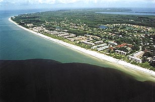
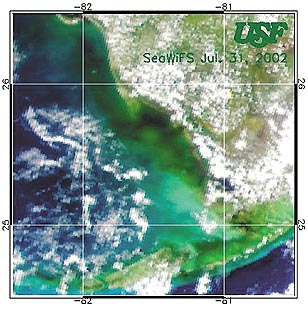 Satellite
pictures at the time showed the water had trailed along the west coast
of Florida from the Caloosahatchee and intensified when it reached western
Florida Bay off the Shark River just below Marco Island and Naples. Researchers
concluded later that the black water was a complex interaction among red
tide and other algae blooms mixing with river runoff, said Beverly Roberts
of FMRI. Few in the scientific community would say if they think July's
dark water is a repeat event, and Roberts said it could just as likely
be normal river runoff. Fresh water is much darker than sea water and would
float along the surface of the gulf. "That can extend miles into the gulf,"
she said.
Satellite
pictures at the time showed the water had trailed along the west coast
of Florida from the Caloosahatchee and intensified when it reached western
Florida Bay off the Shark River just below Marco Island and Naples. Researchers
concluded later that the black water was a complex interaction among red
tide and other algae blooms mixing with river runoff, said Beverly Roberts
of FMRI. Few in the scientific community would say if they think July's
dark water is a repeat event, and Roberts said it could just as likely
be normal river runoff. Fresh water is much darker than sea water and would
float along the surface of the gulf. "That can extend miles into the gulf,"
she said.
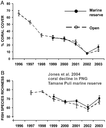
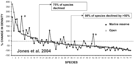
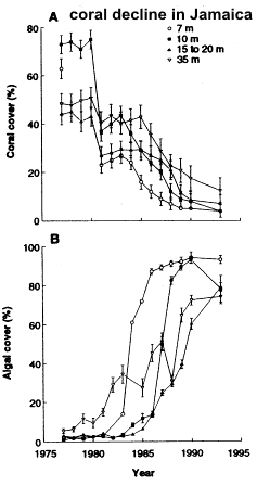 "It
is well acknowledged that coral reefs are declining worldwide but the driving
forces remain hotly debated," said author Camilo Mora at Dalhousie University,
Halifax, Canada. "In the Caribbean alone, these losses are endangering
a large number of species, from corals to sharks, and jeopardizing over
4 billion dollars in services worth from fisheries, tourism and coastal
protection," he added.
"It
is well acknowledged that coral reefs are declining worldwide but the driving
forces remain hotly debated," said author Camilo Mora at Dalhousie University,
Halifax, Canada. "In the Caribbean alone, these losses are endangering
a large number of species, from corals to sharks, and jeopardizing over
4 billion dollars in services worth from fisheries, tourism and coastal
protection," he added.