by Dr J Floor Anthoni (2000)
www.seafriends.org.nz/oceano/beach.htm
People like beaches. People swim in the water
or surf on the waves. The beach is pleasant for a stroll. But why are beaches
found where they are? Why are they not washed into the sea? How are dunes
formed? How do beaches protect? Why are not all beaches the same?
Sediment (sand) is transported by waves, currents and wind. The sand
budget diagram shows how sand moves between the various parts of a beach/dune
system.
Read why our beaches are disappearing, almost everywhere in the world,
and what people do to protect their properties and how we keep doing the
wrong things. Read abut the six laws that define every beach in the world.
Thought provoking and insightful. (36p)
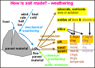
Origin of the sand Sand
is one of the components that make up soil (For a lengthy explanation,
see the chapter on soil). The diagram
shows how soil is made and sand. Every kind of rock weathers slowly by
breaking apart into different substances. Whereas mechanical forces such
as wind, rain, hail and ice may break the rock into smaller parts with
identical chemical properties as the parent material, spontaneous and chemical
weathering change its nature. It produces minerals and nutrients, oxides
of iron and alumina, and silica, which combine into clay. The two other
components are silt and sand (quartz). The combination of clay + silt +
sand is called a loam.
When soil erodes, all of its components wash down into the sea. Here
the water movement sieves the loam into its components, each sedimenting
in different areas of the continental shelf and slope. Sand being the largest,
is transported by waves towards the coast where it may end up on a beach.
Silt and clay may remain in the coastal zone for a while but eventually
settle out in the calm waters of the deep ocean.
At
the end of the last ice age, the ocean's level was about 120m lower than
today, due to the amount of water locked up in the polar and mountain ice
caps. The beaches then were close to the edge of the continental shelf,
and the flat land between there and where they are today, was covered in
forest. Then the climate warmed, the sea level rose, and the beaches moved
landwards, and with them, the sand that formed them. This sand is rather
young, and its quantity has not changed very much since the end of the
ice age. It took about 4000 years for the ocean to rise, and that process
was completed some 6000 years ago.
The diagram shows the extent of the beach sand into the sea. The top
drawing shows a typical beach profile, first descending rapidly near the
coast, then following the slope of the continental shelf to depths over
40m. The sand depth, shown in the bottom drawing, is about 2m near the
shore, decreasing to about 20cm at 40m depth. This point may be 10km out
in sea, depending on the width and slope of the continental shelf. Occasionally
storms are large enough to stir the bottom this deep, and to sweep its
sand towards the shore. It is here that the beach effectively ends.
The beach and dunes The
beach shown in the diagram is typically found together with sand dunes.
Not all beaches are like this (See types of beaches
on this page). In the picture, the levels of high and low tide are shown
and the wet beach is the area between them. The near shore zone extends
to a depth of about 5m. In this zone much sand is moved because it is stirred
easily by most waves. But the shore extends further down, to depths of
20m or more. At some time during a year or decade, the sand here is stirred
by large storms and moved towards the beach.
Going from the wet beach inland, one encounters the dry beach, outside
reach of the waves, but high waves during spring tide may deposit sand
here. This part of the beach is partly formed by wave overwash and by the
wind heaping the sand up. It can even be considered a fore-fore dune. Further
back from here extends the back shore with its fore, mid and rear dunes.
This
diagram shows how the sand moves in the water, on the beach and behind
the beach. Large waves occasionally move sand towards the beach and when
they do, they move large quantities. Closer to the beach the sand movement
is an every day affair and in the breaker zone huge quantities are moved
almost every hour. As waves move sand towards the beach, gravity and back-wash
move it back again at the same rate. Most of the movements cancel each
other out and by and large, the sand remains in place.
The
big difference comes once the sand remains on the beach, dries out during
the low tide and is removed by the sea wind. This sand can no longer be
reached by normal waves. As the wind brushes over the dried beach, it pushes
sand up-hill in a jumping motion (saltation). The sand grains of which
dunes are made, are too large to blow like dust clouds in the wind but
they can saltate rapidly like a moving sheet over the ground. Once particles
fall into the lee (wind shade) of the foredune, they stay there, making
it appear as if the dune rolls backward to the next dune and so on. In
this manner sand is pumped out of the sea. It is the mechanism by which
a beach can repair (rebuild) storm damage. The wind transportation is much
slower than that of water and it may take weeks to repair the damage a
storm can do in one hour.
Storm damage The
picture shows how a beach reshapes itself during a storm and how, afterwards,
it rebuilds itself again. In the top picture the dotted line shows the
beach profile before the storm and the solid profile during the storm.
The two horizontal lines in the water correspond to high and low tide,
the normal extent of the wet beach. Storms not only arrive with higher
waves, but also with a storm surge that lifts the water level. During high
tide the waves attack the beach above its normal level. The foredune is
carved out and its sand creates a new beach at the level of attack. Sometimes
lower down a bank is formed, which helps to break the waves. The storm
brings
new sand but borrows sand from the dunes.
After the storm (bottom picture), the forces of waves and wind gradually
restore the damage wrought. Waves spread the increased amount of
sand and sea winds gradually store it back onto the dunes where
it came from.
Beach cycles A
beach's ability to rebuild itself, makes it a formidable bastion against
the sea. Whereas headlands and cliffs erode, beaches can hold their own
against the anger of the sea.
The components of self repair are: 1) Beach sand being able to dry
because of a receding tide and sunshine and wind; 2) Sea wind to blow the
sand inland; 3) A sand storage in the dunes.
Thus a beach can store sand and grow during years of good sea winds,
few rains or storms and much sunshine. As the sand pump pumps sand
from the wet beach, it causes the beach to lie steeper. During years with
opposite conditions, the beach can erode and lie flatter.
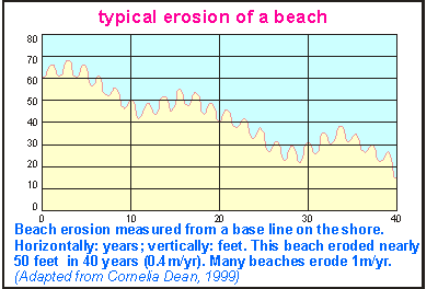
Note
that beach erosion occurs mainly during large storms. These storms also
bring new sand from deeper down towards the beach. Note also that healthy
beaches, having sand pumps with over capacity, may still be capable
of repairing themselves during bad years. But once this self repair mechanism
becomes impaired, beaches become more sensitive to weather conditions and
climate cycles. The diagram shows actual beach erosion of Westhampton Beach
(USA), over a period of 40 years. The situation is typical for many beaches,
all over the world.
A twenty year cycle appears to overlay the general trend of 50 ft (15m)
in 40 years.
Note that the rapid oscillations are depicted as growth
during one year, followed by shrinking during the next year. What the author
intended to show was growth during summer and shrinkage during winter,
an oscillation twice as fast.
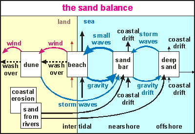
Sediment transport This
rather complicated looking sand balance or sand budget diagram
attempts to depict how sand moves in a dune/beach system. It is a model
to sharpen our understanding. Scientists use such models to study the transport
of sediment near beaches. From left to right, traversing the four boxes
(compartments), runs the profile of a beach. The size of the boxes could
be a part of the beach or the entire beach, and it is called a 'beach cell'.
Sand can move out or into the beach cell by coastal drift parallel to the
coast (sea currents). Sand moves towards the beach by wave action and away
from the beach by gravity down its gradual slope.
The yellow part depicts the dry sand: the dry beach and the dunes. In
the lower left corner the origin of the sand is shown. Sand arises from
coastal erosion and is transported by rivers towards the sea.
The blue part comprises the wet sand: the wet beach, the nearshore
with possible sand bank and the offshore deep sand compartments.
As rivers deposit sand nearshore and offshore, it enters the corresponding
compartments. The land area that drains directly into the beach cell (catchment
area) erodes at a rate depending on land use and rock type.
Following the boxes from right to left, the sand in the deep sand compartment
is stirred only by large waves that may pull sand towards the beach or
allow it to drift deeper down by the force of gravity.
Sand moving out of the deep sand compartment towards the beach, enters
the sand bar or nearshore compartment which is subject to much more wave
action and corresponding sand movement. From there, the sand is moved to
the intertidal zone, the actual beach. Sea winds move it further onto the
dunes but large waves can do so too by washing over the dry beach and dunes.
Sand can also be lost this way, ending up further inland or back into rivers
or estuaries. The breaker zone is the area with the highest transport of
sand. Waves keep large volumes of sand in suspension, allowing it to be
moved by ocean currents, tidal currents or wind induced currents. Some
beaches are claimed to move half a million cubic metres of sand one way
only, each year, the equivalent of 70,000 large truck loads or 200
trucks every day of the year!
As can be seen from the above, sediment transport along the coast is
a complicated process, which is difficult or even impossible, to measure.
Reader please note that sand under water does not move by gravity as
told by many, and as is true on the dunes,but because sand is only marginally
heavier than water, its movement down-hill is different. Because wave action
diminishes rapidly with depth, the sand bottom is more tranquil deeper
down. Sand just moves from where it is swept up to areas of tranquility
where it settles out, entirely by chance.
Transport
and sedimentation The diagram shown here is
of utmost importance in understanding how material is transported by water
(and wind). Theoretical work was done by the British mathematician Sir
George Gabriel Stokes (1819-1903), who formulated that drag experienced
by a perfectly round sphere falling through a medium (straight line above)
is proportional to diameter and speed. For the sake of simplicity, he assumed
that the flow of the medium was laminar, thus without eddies that would
increase friction. In practice, this is not so, hence the left and right-hand
curves, which have been established experimentally. The diagram spans enormous
scales: vertically soil particles from 1 micron to 10mm and horizontally
water velocities from 0.1mm/s to 10m/s (36km/h). The right-hand curve shows
what water speeds are necessary to erode a cohesive bed, whereas the left-hand
curve shows at which speeds the moving particles start settling out again.
The graph shows that pebbles
(grey size zone) are dislodged at about 100cm/s (1m/s), but settle down
at about 20 cm/s. Sand (yellow zone) moves more easily, but silt and clay
(brown zones) are hard to dislodged, once clumped together, whereas they
need almost stagnant water to settle out again.
It shows how a beach is
formed by a wave's forward wash, as long as the particles can resist its
back wash. It also shows that mud flats cannot form where wind blows, and
it illustrates that mud cakes, deposited by cyclonic rain storms, may take
a decade of lesser storms to be worn away.
Reader, please note that
a similar diagram is required to explain erosion and deposition by wind,
but this important work has not been done. Since particles that are moved
by air follow the same logic, and air being 800 times lighter than water,
the wind transportation and sedimentation diagram can be approximated by
shifting the horizontal scale by an unknown quantity to the right (for
instance, 100cm/s may read 100km/h). Winds strong enough to shift pebbles
are uncommon, whereas silt and mud stay air-borne. As a result, a narrow
range of particles forms dunes (sand of 0.2-1.0 mm). Reader please note
that for this size range, the erosion curve runs almost vertical, meaning
that small sand particles behave like much bigger ones, a freak property
of nature. Dunes and beaches are thus freak events (theoretically impossible).
The fact that also tides are needed, makes them even more exceptional.
Why
is sand deposited on a beach? Why does sand stay put as
the water draws back from a beach? Scientists say that the water that pushes
sand up the beach, partly flows back through the sand bed. Thus the amount
of water flowing back over the sand bed is less than which arrived there,
and the sand stays. This is a myth because the amount of water draining
back through the beach sand is negligible compared to what flows back over
the sand, and there is a much better explanation.
Sand is transported over
the sea bed towards the beach when waves 'stumble' such that their crests
become narrower than their troughs. This produces a swift forward flow
followed by a slower backward flow.
On the beach the top of
the wave breaks and mingles with the foot of the wave, both dashing forward
with a force driven by the energy from the height and speed of the collapsing
wave. The resulting rush of water is fast and strong and moves sand effortlessly
up the beach. The water then comes to a rest as the sand particles settle
out. The water then begins flowing back down the beach, first slowly and
then faster until it dislodges cohesive sand grains. But the forcing power
is much less than that of the on-rushing waves. The particles that settled
at the top of the forward rush, stay because of the hysteresis (lagging
behind) between erosion speed and settling speed in the diagram above.
Thus
sand settles on the beach only when the tide recedes.
How
does sand move to deeper depths? The common idea is that
sand simply flows downhill, but this idea cannot work because the bottom
gradient is so small (the sand bottom is nearly horizontal). We know that
'stumbling' waves move the sand towards the beach, so how can it flow away
from the beach?
It happens by those waves
that do not 'stumble' but do stir the bottom, such that the forward motion
of the water over the sea bottom is about the same as the backward motion.
Sand is then moved both towards and from the beach, but as it accidentally
reaches deeper water, the water movement becomes less, allowing it to settle
out. Sand that accidentally moved to shallower water, keeps moving until
it is accidentally moved to deeper water. Eventually the bottom becomes
so deep that even the deepest waves can no longer transport the sand towards
the beach. From this boundary, the sand keeps moving towards the deep,
and this is where the beach ends. See the chapter on mining
the sea sand for more information.
Very light particles such
as mud (silt + clay) move in this manner all the way to the edge of the
continental shelf and clay moves even further down the continental slope.
It should be noticed that
currents, such as tidal currents, play an important role at these depths
in combination with deep (long) waves.
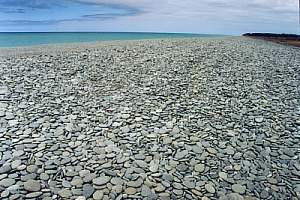
The
mystery of the pebble beaches Many 'beaches' do not consist
of sand but of pebbles or boulders, sometimes with sandy beaches in between.
Why is this so, whereas there occurs so much sand in the sea, starting
right at the foot of the pebble beach? The photo shows such a beach, having
formed a tall and wide dyke. The answer must be found in the sedimentation/
transportation diagram above. First of all, the coarse material must be
available, such as originating from a fast flowing river nearby. Since
pebbles do not move as easily as sand, pebble beaches occur only close
to the origin of their material (a river). Only fast water movements in
excess of 1m/s are capable of moving pebbles, so pebble beaches form only
along very exposed shores. The reason that they are not topped over by
sand, is that pebbles are capable of staying put much better than sand,
resisting the wave's back-wash much better. As a result, they form steep
beaches with strong back wash, too strong for sand to settle out. So the
sand remains at the foot of the pebble beach. However, in less exposed
places, the process reverses, allowing sand to lay over a deeper bed of
pebbles. As a result one may find sand and pebble beaches seemingly 'alternating'.
Note that pebbles laying on top of the sand, prevent the formation of dunes.
Note that all pebbles on the photo have the same flat shape which allows
them to be transported easily in water, while also staying put outside
the water.
Where a variety of coarse
material exists, ranging from pebbles to large boulders, one finds the
boulders cast high up the beach or along the sides of pocket beaches, out
of reach of average storms. Underneath or more towards the middle of the
beach, one finds successively smaller stones. With it the slope of the
beach also becomes more gradual.
Sometimes big boulders are
found above the foredune and it is thought that they were displaced by
tsunamis.
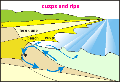
Rips and cusps Some
beaches are notorious for their rips. Rips are unpredictable currents,
flowing away from the beach. They pull swimmers into deeper water and are
very focused and strong. Rips arise when breaker upon breaker pushes new
water onto the beach, not allowing much time for it to flow back. Normally
a wave that runs up a beach will flow back underneath the next one, causing
an undertow current, familiar to swimmers. Where waves arrive in rapid
succession, a rip may occur, allowing the piled-up water to flow back to
the sea.
Because rips are narrowly focused currents, swimmers should swim out
of them in a direction parallel to the beach. Where rips occur, the water
level is lowest and so are the waves. Where water flows towards the beach,
both the water level and the waves are highest. A swimmer should swim to
such a place. Some beaches have irregularities such as under water reefs
where rips always form. Don't swim near reefs and groynes.
This
diagram provides an aerial view of rips and cusps. The left side shows
waves heading straight for the shore. If the shore is exactly the same
everywhere, a rip may form anywhere. It causes a current jet back to sea
and two corresponding deep eddies.
When the wind blows at an angle to the beach, a regular pattern of cusps
(latin word for spear points) appears in the beach, particularly at high
tide. The beach is lowest at a cusp and highest in between. Each cell produces
a
circulating current pattern. Along the beach, the cusps are synchronised
by an edge wave running along the beach in the breaker zone. This
wave dips at each cusp and rises in between.
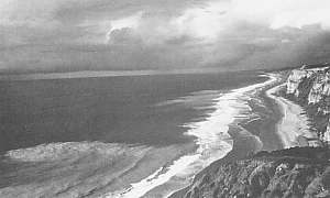
In this photo, a rip has formed in the foreground and one
in the middle ground. Visible by their plumes of sediment, rips may extend
one or two hundred metres out to sea. Where they occur, they interfere
with the waves.
Photo Van Dorn, 1974.
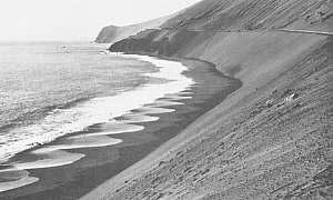
Cusps forming along a beach. Note how the pattern changes
as the beach curves towards windward. In the distance the waves arrive
at the beach on right angles and rips start where cusps end.
Photo Van Dorn, 1974.
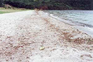
Types of beach Beaches differ in shape, according to the forces that created them:
waves, tides and wind. They also differ according to the material available:
mud, sand, iron sand, shells, cobbles, boulders, etc. Using photographs
of beaches in New Zealand, it can be shown that each beach has its own
characteristics that make it unique. For more pictures of New Zealand beaches,
see Our disappearing beaches. The detailed sand
photographs of the sand are 21 by 14 mm.
The
sheltered crater lake Rotokawau near Rotorua, has no beaches because there
is not enough wind to make waves large enough.
The north-eastern beach of Lake Okataina, near Rotorua, lies
at the end of a 5.5 km long wind fetch over its waters. Waves are strong
enough to make this wide beach of feather light pumice. Because the wind
is lifted off this beach by the high hills around, and absence of tides,
dunes cannot form.
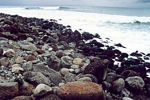
The famous surfing beach at Raglan consists of loosely strewn
cobbles and boulders. Dunes cannot form here from this heavy material.
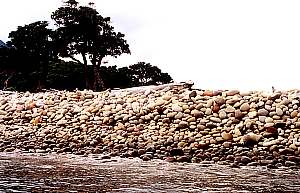
Little Barrier Island boulder spit is located at the sheltered
side of Little Barrier Island. Large waves sweep around the island and
deposit these boulders here, the larger ones towards the end of the spit
(on right), and above the smaller ones. Larger stones make steeper slopes.
The boulders are perfectly smooth, indicating that they are moved quite
frequently.
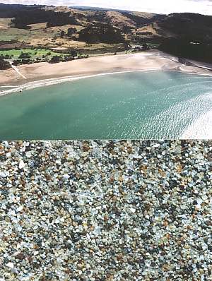
Goat Island beach near Leigh, is a wet beach, located in
the shelter of Goat Island (top left) at the base of steep cliffs.
Its sand is course, made up of rock and shell fragments. There are no dunes.
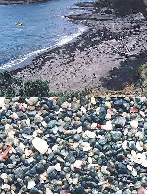
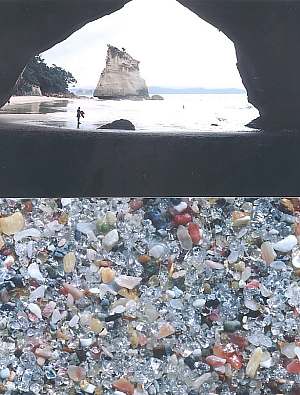
Cathedral Cove near Hahei is a wet beach at the base of steep
cliffs. Its clean sand consists of coarse quartz and other hard components
(feldspars), with few shell fragments (white). There are no dunes.
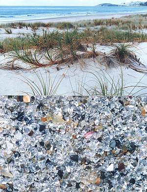
Pakiri Beach near Leigh consists of clean quartz sand mixed
with very few shell fragments. It is over 20 km long and has extensive
dunes. In the north, towards Mangawhai, the dunes have been planted in
exotic pine forest.
Hatfields Beach near Orewa is a sheltered beach, polluted
by fine sediment, microscopic algae and possibly bacteria. Its dune spit
has been flattened for a causeway (State Highway 1) and recreational grassland.
It is eroding badly. Behind the spit is a narrow estuary with mangrove
trees.
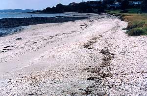
Shelly beaches occur in sheltered places, bordered by muddy
bottoms. The shells, consisting of light-weight limestone, can be washed
up easily. They can also dissolve back into the sea water within a period
of only 20 years. When shells like cockles are no longer abundant, these
beaches disappear. Note that shells overlaying sand, prevent dunes from
forming.
 Sand
is one of the components that make up soil (For a lengthy explanation,
see the chapter on soil). The diagram
shows how soil is made and sand. Every kind of rock weathers slowly by
breaking apart into different substances. Whereas mechanical forces such
as wind, rain, hail and ice may break the rock into smaller parts with
identical chemical properties as the parent material, spontaneous and chemical
weathering change its nature. It produces minerals and nutrients, oxides
of iron and alumina, and silica, which combine into clay. The two other
components are silt and sand (quartz). The combination of clay + silt +
sand is called a loam.
Sand
is one of the components that make up soil (For a lengthy explanation,
see the chapter on soil). The diagram
shows how soil is made and sand. Every kind of rock weathers slowly by
breaking apart into different substances. Whereas mechanical forces such
as wind, rain, hail and ice may break the rock into smaller parts with
identical chemical properties as the parent material, spontaneous and chemical
weathering change its nature. It produces minerals and nutrients, oxides
of iron and alumina, and silica, which combine into clay. The two other
components are silt and sand (quartz). The combination of clay + silt +
sand is called a loam. 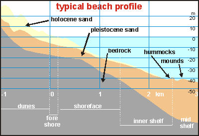 At
the end of the last ice age, the ocean's level was about 120m lower than
today, due to the amount of water locked up in the polar and mountain ice
caps. The beaches then were close to the edge of the continental shelf,
and the flat land between there and where they are today, was covered in
forest. Then the climate warmed, the sea level rose, and the beaches moved
landwards, and with them, the sand that formed them. This sand is rather
young, and its quantity has not changed very much since the end of the
ice age. It took about 4000 years for the ocean to rise, and that process
was completed some 6000 years ago.
At
the end of the last ice age, the ocean's level was about 120m lower than
today, due to the amount of water locked up in the polar and mountain ice
caps. The beaches then were close to the edge of the continental shelf,
and the flat land between there and where they are today, was covered in
forest. Then the climate warmed, the sea level rose, and the beaches moved
landwards, and with them, the sand that formed them. This sand is rather
young, and its quantity has not changed very much since the end of the
ice age. It took about 4000 years for the ocean to rise, and that process
was completed some 6000 years ago.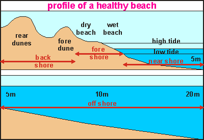 The
beach shown in the diagram is typically found together with sand dunes.
Not all beaches are like this (See
The
beach shown in the diagram is typically found together with sand dunes.
Not all beaches are like this (See 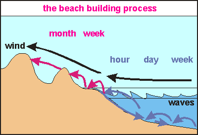 This
diagram shows how the sand moves in the water, on the beach and behind
the beach. Large waves occasionally move sand towards the beach and when
they do, they move large quantities. Closer to the beach the sand movement
is an every day affair and in the breaker zone huge quantities are moved
almost every hour. As waves move sand towards the beach, gravity and back-wash
move it back again at the same rate. Most of the movements cancel each
other out and by and large, the sand remains in place.
This
diagram shows how the sand moves in the water, on the beach and behind
the beach. Large waves occasionally move sand towards the beach and when
they do, they move large quantities. Closer to the beach the sand movement
is an every day affair and in the breaker zone huge quantities are moved
almost every hour. As waves move sand towards the beach, gravity and back-wash
move it back again at the same rate. Most of the movements cancel each
other out and by and large, the sand remains in place.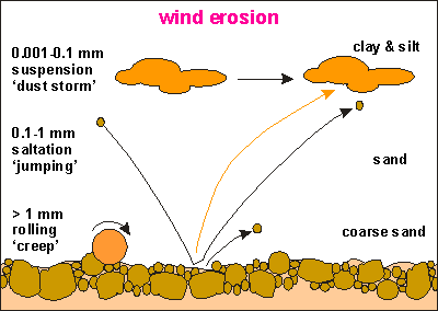 The
big difference comes once the sand remains on the beach, dries out during
the low tide and is removed by the sea wind. This sand can no longer be
reached by normal waves. As the wind brushes over the dried beach, it pushes
sand up-hill in a jumping motion (saltation). The sand grains of which
dunes are made, are too large to blow like dust clouds in the wind but
they can saltate rapidly like a moving sheet over the ground. Once particles
fall into the lee (wind shade) of the foredune, they stay there, making
it appear as if the dune rolls backward to the next dune and so on. In
this manner sand is pumped out of the sea. It is the mechanism by which
a beach can repair (rebuild) storm damage. The wind transportation is much
slower than that of water and it may take weeks to repair the damage a
storm can do in one hour.
The
big difference comes once the sand remains on the beach, dries out during
the low tide and is removed by the sea wind. This sand can no longer be
reached by normal waves. As the wind brushes over the dried beach, it pushes
sand up-hill in a jumping motion (saltation). The sand grains of which
dunes are made, are too large to blow like dust clouds in the wind but
they can saltate rapidly like a moving sheet over the ground. Once particles
fall into the lee (wind shade) of the foredune, they stay there, making
it appear as if the dune rolls backward to the next dune and so on. In
this manner sand is pumped out of the sea. It is the mechanism by which
a beach can repair (rebuild) storm damage. The wind transportation is much
slower than that of water and it may take weeks to repair the damage a
storm can do in one hour.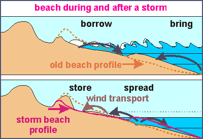 The
picture shows how a beach reshapes itself during a storm and how, afterwards,
it rebuilds itself again. In the top picture the dotted line shows the
beach profile before the storm and the solid profile during the storm.
The two horizontal lines in the water correspond to high and low tide,
the normal extent of the wet beach. Storms not only arrive with higher
waves, but also with a storm surge that lifts the water level. During high
tide the waves attack the beach above its normal level. The foredune is
carved out and its sand creates a new beach at the level of attack. Sometimes
lower down a bank is formed, which helps to break the waves. The storm
brings
new sand but borrows sand from the dunes.
The
picture shows how a beach reshapes itself during a storm and how, afterwards,
it rebuilds itself again. In the top picture the dotted line shows the
beach profile before the storm and the solid profile during the storm.
The two horizontal lines in the water correspond to high and low tide,
the normal extent of the wet beach. Storms not only arrive with higher
waves, but also with a storm surge that lifts the water level. During high
tide the waves attack the beach above its normal level. The foredune is
carved out and its sand creates a new beach at the level of attack. Sometimes
lower down a bank is formed, which helps to break the waves. The storm
brings
new sand but borrows sand from the dunes.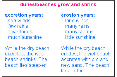 A
beach's ability to rebuild itself, makes it a formidable bastion against
the sea. Whereas headlands and cliffs erode, beaches can hold their own
against the anger of the sea.
A
beach's ability to rebuild itself, makes it a formidable bastion against
the sea. Whereas headlands and cliffs erode, beaches can hold their own
against the anger of the sea.
 Note
that beach erosion occurs mainly during large storms. These storms also
bring new sand from deeper down towards the beach. Note also that healthy
beaches, having sand pumps with over capacity, may still be capable
of repairing themselves during bad years. But once this self repair mechanism
becomes impaired, beaches become more sensitive to weather conditions and
climate cycles. The diagram shows actual beach erosion of Westhampton Beach
(USA), over a period of 40 years. The situation is typical for many beaches,
all over the world.
Note
that beach erosion occurs mainly during large storms. These storms also
bring new sand from deeper down towards the beach. Note also that healthy
beaches, having sand pumps with over capacity, may still be capable
of repairing themselves during bad years. But once this self repair mechanism
becomes impaired, beaches become more sensitive to weather conditions and
climate cycles. The diagram shows actual beach erosion of Westhampton Beach
(USA), over a period of 40 years. The situation is typical for many beaches,
all over the world.
 This
rather complicated looking sand balance or sand budget diagram
attempts to depict how sand moves in a dune/beach system. It is a model
to sharpen our understanding. Scientists use such models to study the transport
of sediment near beaches. From left to right, traversing the four boxes
(compartments), runs the profile of a beach. The size of the boxes could
be a part of the beach or the entire beach, and it is called a 'beach cell'.
Sand can move out or into the beach cell by coastal drift parallel to the
coast (sea currents). Sand moves towards the beach by wave action and away
from the beach by gravity down its gradual slope.
This
rather complicated looking sand balance or sand budget diagram
attempts to depict how sand moves in a dune/beach system. It is a model
to sharpen our understanding. Scientists use such models to study the transport
of sediment near beaches. From left to right, traversing the four boxes
(compartments), runs the profile of a beach. The size of the boxes could
be a part of the beach or the entire beach, and it is called a 'beach cell'.
Sand can move out or into the beach cell by coastal drift parallel to the
coast (sea currents). Sand moves towards the beach by wave action and away
from the beach by gravity down its gradual slope.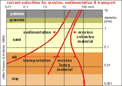 Transport
and sedimentation
Transport
and sedimentation
 The
mystery of the pebble beaches
The
mystery of the pebble beaches
 Some
beaches are notorious for their rips. Rips are unpredictable currents,
flowing away from the beach. They pull swimmers into deeper water and are
very focused and strong. Rips arise when breaker upon breaker pushes new
water onto the beach, not allowing much time for it to flow back. Normally
a wave that runs up a beach will flow back underneath the next one, causing
an undertow current, familiar to swimmers. Where waves arrive in rapid
succession, a rip may occur, allowing the piled-up water to flow back to
the sea.
Some
beaches are notorious for their rips. Rips are unpredictable currents,
flowing away from the beach. They pull swimmers into deeper water and are
very focused and strong. Rips arise when breaker upon breaker pushes new
water onto the beach, not allowing much time for it to flow back. Normally
a wave that runs up a beach will flow back underneath the next one, causing
an undertow current, familiar to swimmers. Where waves arrive in rapid
succession, a rip may occur, allowing the piled-up water to flow back to
the sea.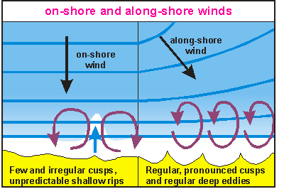 This
diagram provides an aerial view of rips and cusps. The left side shows
waves heading straight for the shore. If the shore is exactly the same
everywhere, a rip may form anywhere. It causes a current jet back to sea
and two corresponding deep eddies.
This
diagram provides an aerial view of rips and cusps. The left side shows
waves heading straight for the shore. If the shore is exactly the same
everywhere, a rip may form anywhere. It causes a current jet back to sea
and two corresponding deep eddies.
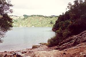 The
sheltered crater lake Rotokawau near Rotorua, has no beaches because there
is not enough wind to make waves large enough.
The
sheltered crater lake Rotokawau near Rotorua, has no beaches because there
is not enough wind to make waves large enough.