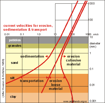
How fast must water flow?
 To
estimate the water speed necessary for moving such large boulders, we need
to extend the work of Heezen and Hollister, as shown on right. These scientists
actually measured what water speeds were needed to shift sand particles
of a large range of sizes (vertical scale). We've extended the graph upward
by extrapolating it, and one can see that a round block of 1m (1000mm)
diameter can be moved by a water speed of about 1000cm/s (right-hand red
curve) or 10m/s or 10x3600m/h or 36 km/h. The block settles down at about
one quarter that speed (leftmost red curve). To
estimate the water speed necessary for moving such large boulders, we need
to extend the work of Heezen and Hollister, as shown on right. These scientists
actually measured what water speeds were needed to shift sand particles
of a large range of sizes (vertical scale). We've extended the graph upward
by extrapolating it, and one can see that a round block of 1m (1000mm)
diameter can be moved by a water speed of about 1000cm/s (right-hand red
curve) or 10m/s or 10x3600m/h or 36 km/h. The block settles down at about
one quarter that speed (leftmost red curve).
36km/h may not seem a lot, but this should be the water's speed at
the entrance to the cave, 40m deep. Because water velocity decreases rapidly
with depth, the water's speed at the surface must be many times 36km/h,
at least 100km/h, and this becomes quite respectable. We've called this
arch a hell-hole, and now you may understand why.
You can also understand, that once a boulder moves up the inside ramp,
it moves into shallower water, picking up water with higher velocity, until
at the exit, it may travel at over 100km/h, enough to be spat far out. |
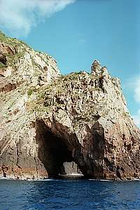
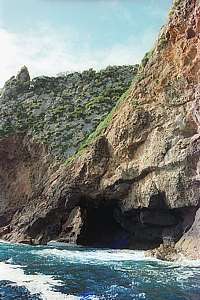
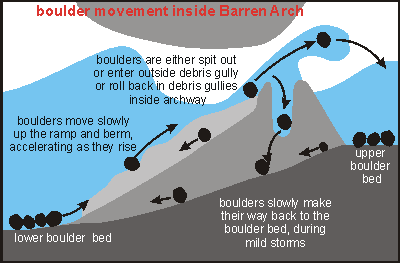 Ever
since it was first discovered, in the early years of SCUBA diving, divers
have recognised it for what it is: a barren arch. Recent attempts to rename
it in more gentle terms (Splendid Arch), are doing a disservice
to this most unique of all archways. Already many years ago I figured out
what is happening here, and since then kept a watchful eye out for changes
that could confirm my conclusions. Essentially there is a beach in the
sheltered northern cove, consisting of large round boulders of 0.5 to 1.5m
diameter. During mild storms, these stones move down the slope outside
the cave, being mopped towards its entrance at about 40m depth. During
cyclonic storms (hurricanes) coming from the north-east, these stones are
swept through the cave to be spit out at the shallow end. Those that don't
make it, roll back inside the cave along two hollow grooves (a debris gully)
on each side. In the process, wherever they collide with the inside of
the cave, all life is ground off. After a large storm, one can find many
new round stones on top of the more embedded ones, outside the archway
in the shallow northern cove. The diagram shows the basic idea.
Ever
since it was first discovered, in the early years of SCUBA diving, divers
have recognised it for what it is: a barren arch. Recent attempts to rename
it in more gentle terms (Splendid Arch), are doing a disservice
to this most unique of all archways. Already many years ago I figured out
what is happening here, and since then kept a watchful eye out for changes
that could confirm my conclusions. Essentially there is a beach in the
sheltered northern cove, consisting of large round boulders of 0.5 to 1.5m
diameter. During mild storms, these stones move down the slope outside
the cave, being mopped towards its entrance at about 40m depth. During
cyclonic storms (hurricanes) coming from the north-east, these stones are
swept through the cave to be spit out at the shallow end. Those that don't
make it, roll back inside the cave along two hollow grooves (a debris gully)
on each side. In the process, wherever they collide with the inside of
the cave, all life is ground off. After a large storm, one can find many
new round stones on top of the more embedded ones, outside the archway
in the shallow northern cove. The diagram shows the basic idea.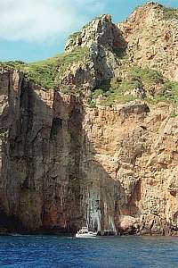
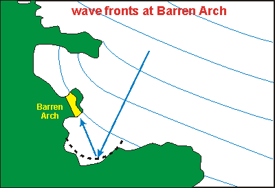 Why
do we find this type of arch only here and nowhere else? The answer must
be found in the topology of the area. I think that the deep steep wall
at the southern cove forms an almost ideal parabolic reflector to throw
wave fronts back and concentrate them onto the archway's deep entrance.
In doing so it could focus and amplify waves by at most three times. In
the picture a black dashed curve shows the idea. It is known that vertical
walls reflect waves back without absorbing any energy. Ironically, the
life attached to such a deep and steep wall, experiences this as shelter,
reason why an exposed steep wall like Macro City can have sensitive life
growing on it.
Why
do we find this type of arch only here and nowhere else? The answer must
be found in the topology of the area. I think that the deep steep wall
at the southern cove forms an almost ideal parabolic reflector to throw
wave fronts back and concentrate them onto the archway's deep entrance.
In doing so it could focus and amplify waves by at most three times. In
the picture a black dashed curve shows the idea. It is known that vertical
walls reflect waves back without absorbing any energy. Ironically, the
life attached to such a deep and steep wall, experiences this as shelter,
reason why an exposed steep wall like Macro City can have sensitive life
growing on it.