by Dr J Floor Anthoni 2000
www.seafriends.org.nz/oceano/tides.htm
The pull between moon and earth causes the
sea level to go up and down, in most places twice daily but in some places
only once. Very few places don't experience tides at all. It has been a
mystery for a long time, and even today is not taught correctly at school.
The moon pulls the earth slightly oval. This
buckle in the earth's crust travels at high speed. Tide waves form in a
circular motion in the ocean basins.
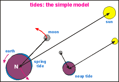
The simple model The
easiest way to understand tides is shown in this drawing. The earth turns
around the sun and is kept in orbit by the gravitational pull between them.
Likewise the moon is kept in orbit around the earth by the gravitational
pull between these two. Each causes a bulge of water on the nearest side
and an equal bulge on the other side. The tide is thus composed of two
bulges of water (four, in fact), travelling around the world as the world
spins round. When moon and sun are aligned, their respective tide bulges
add together to a spring tide every two weeks. When sun and moon
are at right angles (the smaller drawing), it causes the bulge of the sun
to add to the low tide, resulting in an overall higher low tide but lower
high tide. This is called the neap tide, every two weeks in between
spring tides.
Seen from the north pole, the earth rotates in a counter-clockwise direction:
a point on the equator moves east-ward; the sun rises in the east. The
tidal bulge thus moves westward. In our solar system, all heavenly bodies
rotate in approximately the same plane and in the same direction. The rotation
of earth and moon is in the same direction, earth doing its spin in exactly
24 hours and the moon in about 28 days. This difference delays the tide
each day by 1/28th day or about 51 minutes. The solar tide is 24 hours.
This simple model has been used for centuries to calculate tide levels
all over the world but it has a number of insurmountable problems.
Wave speed: since the tide is just another gravity wave travelling
along the ocean's surface, it must satisfy the laws for waves as explained
in the wave chapter. For a wave to travel along
the equator of 40,000 km in 25 hours, requires a speed of around 1600 km/hr,
which is not sustainable. The maximum wave speed in a 'channel' of 5000m
deep is about 800km/hr. Average depth of the ocean is around 3800m, demanding
a lower speed still.
Bouncing off continents: As the tide wave reaches a continent, most
of it will be bounced back off the continental shelf, causing a tide wave
of almost equal height to run in the opposite direction. This is not observed
in real life.
Starting and stopping: as the tide wave apparently needs to start
at one continent and stop at the other, it would be larger at the continent
where it arrives and smaller where it came from. During the starting and
stopping, far too much energy would be wasted. This is not in accordance
with tidal movements world-wide.
Zero, one and two tides each day: there are places without tide,
with one tide and most with two tides each day. This cannot be explained.
Tide height: the height of the tide, the difference between high
and low tide, does not follow the two-bulge idea which suggests that the
tide should be maximal around the equator or on opposite sides of a large
ocean. Near the equator one can find places without tides and places with
near-maximal tides.
Tide timing: high tide occurs at different times of the lunar cycle,
depending more on one's place on Earth than on the position of the moon.
The balancing bulge on the other side is hard to explain.
There is obviously a better explanation of how tides move around the world.
Tide tables are constructed
by analysing a long tidal record for a particular locality and finding
the contributions to the tidal curve made by its various components. It
is in fact a method of breaking the tidal wave form into its components
or causes. The main component is the moon, then the sun, then the elliptical
motion of the moon around the earth, and others, as shown in the table
below:
Main components
Name
Period (hr)
Relative size
Principal lunar
M2
12.42
100
Principal solar
S2
12.00
47
Large lunar elliptic
N2
12.66
19
Lunar-solar declinational
K2
11.97
13
Lunar-solar declinational
K1
23.93
58
Principal lunar declinational
O1
25.82
42
Principal solar declinational
P1
24.07
19
From the relative sizes of each component, it can be seen
that, should all components work together, the tide could almost double
its size during special spring tides.
(Adapted from Harris, 1985)
The buckling crust In
the early seventies, as computers were able to model wave behaviour, they
were able to show that tide waves would run in ways to prevent loss of
energy. Instead of running east to west, tide waves run around in circles
(clockwise and CCW on both hemispheres) around islands, and certain points
in the sea, called nodes. The map shown here shows the tides circling
around their nodes in 30º increments (12 parts to 25/2 hours) in the
directions of the solid arrows. Each solid line connects tide levels in
the ocean that are at the same phase. The dotted lines show tide amplitude
(half tide height) in cm. This early model has been shown to agree with
reality and, for its time, has been a remarkable achievement of computational
mathematics. From this map one can see that some places in the world (the
nodes) have no tides, others two (12 lines) and a few places one (24 lines).
(Picture from Van Dorn, 1974)
This new model does away with the objections mentioned for the simple
model:
Tide waves follow shorter paths in twelve hour rotations, never exceeding
the maximum wave speed of about 800 km/hr.
Tide waves do not bounce off continents by hitting them squarely.
Instead, they follow along their coasts.
There is no starting and stopping but a continuous motion. The standing
waves absorb minimal energy.
There is no balancing bulge. Instead, tide waves run in twelve hour
circles.
There can be none, one or two tides per day.
The time of high tide depends both on the lunar cycle and the place
on Earth.
Tide waves are standing waves, expending the least energy.
Note that the tide patterns in the oceans are rotating standing waves,
not very different from the vibrating of a violin string. Like the fiddlestick
of the violonist, stroking the string close to where it is attached, the
forces of the moon stroke the ocean's waters into the pattern of standing
waves according to the natural resonance periods of the ocean basins. It
is thought that this is done by the buckling of the earth's crust.
As has been observed with other stellar objects rotating in close proximity,
their round shapes become distorted by gravity. Likewise the earth is pulled
into a slightly oval form, independently by both the moon and the sun.
As the earth rotates, these bulges (body tides) travel round the
planet in the times calculated above. So the simple two-bulge model is
true for the earth's crust. Being 2.8 times denser than water, and much
deeper than the oceans, a body tide can easily run as a gravity wave at
the calculated speeds without losing much energy. The amplitude of the
earth's body tide is typically 0.1-0.4m (0.2-0.8m wave height), which is
quite negligible compared to the earth's diameter of 12,600,000m. The Earth's
mantle has enough flexibility to allow such a wave to pass effortlessly.
[Note
that this body tide is also estimated at 0.1m amplitude or 0.2m high to
low, as measured by satellites]
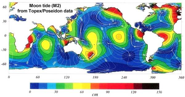
Since the TOPEX/Poseidon satellite has been measuring
surface height data, the oscillating surface of the oceans
due to moon tides could be measured and mapped. Note
that the nodes correlate with areas of no tide change,
except where these rotate around islands such as New
Zealand and Madagascar. Highest tidal ranges are found
where continental coasts distort the tide wave. http://svs.gsfc.nasa.gov/stories/topex/images/TidalPatterns_hires.tif
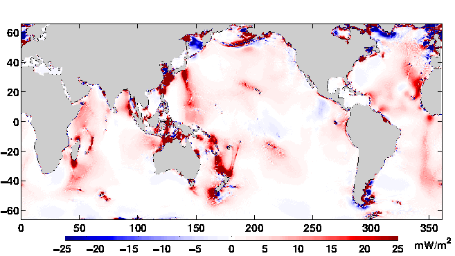
Once the actual oscillation of the sea could be measured, one was able
to compare it with calculations from computer models to see if any differences
occurred. The above picture shows where such tide anomalies occur: around
islands where the tide wave distorts most (NZ, Madagascar), and around
deep sea ridges and chains of seamounts (Hawaii, Kermadecs). It is now
thought that these anomalies give rise to deep eddies that transport nutrients
from the deep to the surface, thereby giving rise to unanticipated marine
productivity. Note also how some anomalies correspond with already notable
fishing grounds. Note also that these computer-generated results must be
verified first.
Tides dissipate 3.75 ±
0.08 TW (TeraWatt= 1E12 Watt= 1 million million Watt) of power (Kantha,1998),
of which 3.5 TW are dissipated in the ocean, and much smaller amounts in
the atmosphere and solid earth. The dissipation increases the length of
day by about 2.07 milliseconds per century, it causes the semimajor axis
of moons orbit to increase by 3.86 cm/yr, and it mixes water masses in
the ocean.
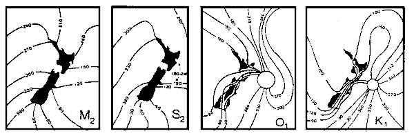
Tides around New Zealand New Zealand, as has been seen above, forms a node around which the
tide runs twice daily. Recent measurements have shown that some of the
nodes of the component waves, are located east of New Zealand
Tides around New Zealand for the main components M2=
lunar , S2= solar , O1= lunar declinational, K1= lunar-solar declinational.
(Adapted from Harris 1985, Heath 1977)
.
Tides and the environment Would the world be different had there been no tides, no moon? Fortunately,
we can find an answer to this question by simply visiting the Mediterranean
Sea. This sea is so enclosed and relatively small, that tides don't exist
(less than 20cm). Life (for people) is quite pleasant there and the underwater
environment counts a high number of species, but the fishery does not sustain
large volumes.
Here in New Zealand, we experience a tide of around 2-3m and its effects
are many:
without tides, dunes cannot form, (see dunes
and beaches). Tides expose sea sand to the wind, which blows it into
dunes. Dunes help protect the land from the sea.
tides condition coasts to wave and tsunami attacks from the sea. Biggest
tsunami damage happens where tides are small or nonexistent, such that
a tsunami can run far inland (Sumatra,Tokyo).
tides create an area of rocky shore where specialised organisms have evolved.
Tides thus increase the biodiversity of the coast (limpets, barnacles,
oysters, etc.)
tides create large areas for specialised organisms within harbours and
embayments (sand and mud flats, mangroves, etc.). such areas may act as
nurseries for various marine species and feeding grounds for others (wading
birds and humans).
tides create currents that mix the water so that surface plankton is spread
and bottom nutrients re-surface. This makes plankton available throughout
the year and down to sunless depths.
tides create currents that transport plankton to sessile filterfeeders
such as clams, sponges, seasquirts, etc, feeding with little effort, thus
growing fast. It creates very rich habitats where currents pass.
tides create currents that transport and mix coastal sediments. Without
them, the coast would be more sensitive to sewage disposal and runoff from
the land. It would support fewer people on the land and fewer fish in the
sea.
 The
easiest way to understand tides is shown in this drawing. The earth turns
around the sun and is kept in orbit by the gravitational pull between them.
Likewise the moon is kept in orbit around the earth by the gravitational
pull between these two. Each causes a bulge of water on the nearest side
and an equal bulge on the other side. The tide is thus composed of two
bulges of water (four, in fact), travelling around the world as the world
spins round. When moon and sun are aligned, their respective tide bulges
add together to a spring tide every two weeks. When sun and moon
are at right angles (the smaller drawing), it causes the bulge of the sun
to add to the low tide, resulting in an overall higher low tide but lower
high tide. This is called the neap tide, every two weeks in between
spring tides.
The
easiest way to understand tides is shown in this drawing. The earth turns
around the sun and is kept in orbit by the gravitational pull between them.
Likewise the moon is kept in orbit around the earth by the gravitational
pull between these two. Each causes a bulge of water on the nearest side
and an equal bulge on the other side. The tide is thus composed of two
bulges of water (four, in fact), travelling around the world as the world
spins round. When moon and sun are aligned, their respective tide bulges
add together to a spring tide every two weeks. When sun and moon
are at right angles (the smaller drawing), it causes the bulge of the sun
to add to the low tide, resulting in an overall higher low tide but lower
high tide. This is called the neap tide, every two weeks in between
spring tides.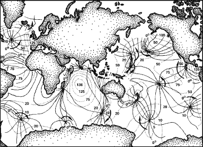 In
the early seventies, as computers were able to model wave behaviour, they
were able to show that tide waves would run in ways to prevent loss of
energy. Instead of running east to west, tide waves run around in circles
(clockwise and CCW on both hemispheres) around islands, and certain points
in the sea, called nodes. The map shown here shows the tides circling
around their nodes in 30º increments (12 parts to 25/2 hours) in the
directions of the solid arrows. Each solid line connects tide levels in
the ocean that are at the same phase. The dotted lines show tide amplitude
(half tide height) in cm. This early model has been shown to agree with
reality and, for its time, has been a remarkable achievement of computational
mathematics. From this map one can see that some places in the world (the
nodes) have no tides, others two (12 lines) and a few places one (24 lines).
(Picture from Van Dorn, 1974)
In
the early seventies, as computers were able to model wave behaviour, they
were able to show that tide waves would run in ways to prevent loss of
energy. Instead of running east to west, tide waves run around in circles
(clockwise and CCW on both hemispheres) around islands, and certain points
in the sea, called nodes. The map shown here shows the tides circling
around their nodes in 30º increments (12 parts to 25/2 hours) in the
directions of the solid arrows. Each solid line connects tide levels in
the ocean that are at the same phase. The dotted lines show tide amplitude
(half tide height) in cm. This early model has been shown to agree with
reality and, for its time, has been a remarkable achievement of computational
mathematics. From this map one can see that some places in the world (the
nodes) have no tides, others two (12 lines) and a few places one (24 lines).
(Picture from Van Dorn, 1974)