Niue's marine ecology by Dr J Floor Anthoni (2004-2005)
www.seafriends.org.nz/niue/ecology.htm
Some of the ecological issues affecting Niue
have been dealt with in the geography/ geology chapter, such as soil and
water. This chapter deals with the ecological issues of Niue's sea.
sea temperature: the sea's surface temperature
can be measured by satellite, but is it right?
sea productivity: Niue is located in
an area of low productivity
coral diversity: low productivity and low
temperatures imply low biodiversity
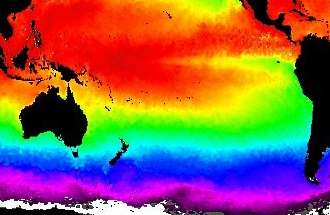
Sea temperature The
map shows global ocean temperatures for the Pacific Ocean in false colours
from purple to red. Absolute values for the sea temperature are thus hard
to guess but a clear picture emerges. As expected, the sea warms gradually
from the South Pole to the Equator in horizontal bands. But these bands
are not strictly horizontal, particularly the green one of the subtropics.
It curves all the way up to the equator along the coast of South America,
due to a strong ocean current moving up this coast. As a result, the Galapagos
Islands on the Equator are as cool as Sydney and Melbourne or even Auckland.
This tongue of cool water moves just south of the equator as it gradually
warms up.
Niue is located on the cool edge of the warm tropics but its waters
are much cooler than those of Indonesia for instance.
Ironically, there exists no official record of the sea temperatures for
Niue, which must soon be remedied, as sea temperatures are related to productivity,
rainfall, drought and hurricanes. The average sea temperature is quoted
as anywhere between 24.7 and 26ºC. In qualitative terms, the water
is just warmer (2ºC) than the Kermadec Islands where coral growth
does not lead to reef formation and where coral diversity is very low.
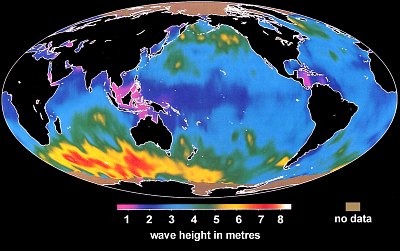
Note
that the Sea Surface Temperature (SST) map was produced by infrared sensing
satellites that cannot pierce the water's surface (infrared light is absorbed
immediately). Thus the SST is indeed the temperature of a very shallow
surface layer, ignoring any cooler water direct underneath. One would expect
waves to mix the water column, which they do, but in the Niue area, average
wave height is rather low, as seen by this satellite map of average wave
heights. The bulge of warm water near Niue may thus not at all represent
the actual situation.
This map was produced from the electrical noise in the reflected radar
signal from various satellites. Scientists soon discovered that the strength
of this noise related to wave height, which allowed them to plot the wave
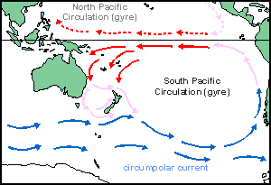
height map seen here. Note the power engine in the South Indian ocean and
south of NZ. This wind and its waves drive the Antarctic circumpolar (going
round the whole pole) current, and probably also the South Pacific gyre
that affects Niue.
Sea productivity No records exist of the productivity of Niue's seas but the chlorophyll
map below gives some important clues. This map shows the amount of green
plant matter (chlorophyll) which is responsible for the productivity in
plants. The map combines both land and sea. As one can see, the South Pacific
is sandwiched between two deserts, Chile and Peru on the East and Australia
on the West. Niue has been marked by a red dot. The productivity of the
sea does not follow the temperature bands as above but depends very much
on a few invisible factors.
Look
at the sea around New Zealand, for instance. NZ is surrounded by a very
productive sea because of invisible currents south and north of it. One
current runs southward along Australia's east coast, mopping nutrients
into the New Zealand area. On its downward course, it encounters a cool
sea which forms a cold front, diverting its course to southern New Zealand.
Likewise, subantarctic currents experience this as a warm front as they
too are diverted towards southern NZ where turbulence causes upwellings
of nutrients. (See ocean/currents
and oceans/specialNZ)
(Picture courtesy of NASA SEAWIFS programme)
Such turbulent upwellings occur also along South America's coast as
the coastal Peru Current cork-screws along the Peruvian coast. This current
becomes diverted by Coriolis forces (due to the spinning of Earth) and
follows a straight path on the equator (See Oceanography/currents/defection).
Here the Coriolis forces focus its beam horizontally into a narrow jet
that sends invisible eddies downward, causing nutrient upwellings along
its entire course as it also gradually warms up. Scientists are studying
the interaction of this
cool tongue and warm pool, as it produces
some unexpected pelagic productivity.
The centre of both North and South Pacific are pools of ultra clear
water with very low productivity, while also located in the world's desert
bands. Evaporation is high, resulting in a higher than normal salt content.
Remarkably, this pool of infertile water travels in a NW direction, past
Niue. This is probably because of the trade winds blowing in the same direction.
Note that chlorophyll-sensing satellites can look down only about 10m into
the sea, so they are unable to view what is happening further down.
For instance, it is quite possible that the ultra clear blue water
overlays a basement of cool nutrient-rich water in which phyto plankton
(plant plankton) can bloom, because the clear water admits so much light
deep down. The productivity of this blue tongue could therefore be higher
than thought, although always much lower than green water at the surface.
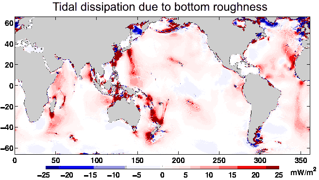
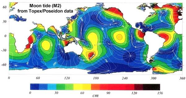
Note that some anomalies in green upwellings have been discovered,
for instance a thin line running from NZ to Niue over the Kermadec Trench
and Ridge and a cloud around French Polynesia and Hawaii. These are caused
by the slow, deep tide waves 'stumbling' over sea bottom irregularities,
resulting in surface currents and local upwellings. The map below shows
how scientists calculated the dissipation (loss of energy) of the tide
wave due to the shape of the sea bottom. It is based on comparing a mathematical
model of the tide wave with actual tide heights measured from satellites.
In places where this tide wave 'stumbles' (shown in red), turbulence occurs
with possible surface mixing and nutrient upwelling. Compare it with the
chlorophyll map above. For Niue this model does not suggest remarkable
upwellings.
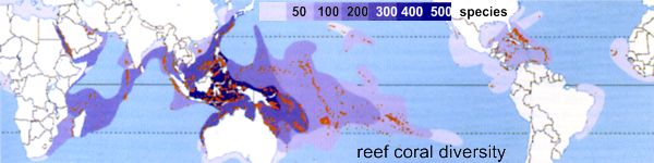
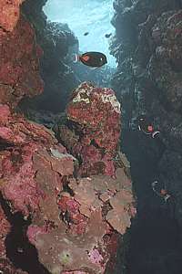
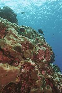
coral diversity Scientists claim to have recorded from Niue, 189 species of coral in
43 genera and 243 species of fish (Spalding et al., 2001). This despite
the fact that the seas around Niue are sparsely populated. Nearby Tonga,
further West has 229 species of fish. Tonga has suffered a major coral
bleaching event in 2000, whereas Niue has not. The world map below shows
coral diversity, which is roughly related to the water's temperature. Niue
is somewhere at the bottom rung with 50-100 species, a lot less than the
189 mentioned before. Our own observations do not justify the figure of
189 either.
Source: Spalding, M D et al. (2001): World Atlas
of coral reefs. Univ Cal Press.
Limiting factors Nature appears to thrive best under high temperatures, predictable
moisture and accompanying evapo-transpiration, zones with varying degrees
of stress and interconnectivity between them. Niue scores low on all these
necessary conditions for maximum biodiversity, even when compared with
cooler New Zealand.
Limiting factors sparse plankton
cool temperature
small island
isolation
hurricanes
Niue is located at the southern boundary of where corals flourish, due
to its low tropical sea temperatures. The sea water is very clear, but
this also means that it contains little food. But perhaps worst of all
is Niue's small size and isolation. Most sea creatures spawn their eggs
freely in the water. The eggs hatch and small larvae find tiny parcels
of food in the surface layers of the sea. Once they can eat what the shore
provides, they settle out of their planktonic stage on the shore. But in
the meantime, currents will have transported them away from Niue, in a
deep blue ocean, so they die.
This would not necessarily be a problem if other islands send their
larvae towards Niue, but in the SE direction, where the trade winds and
the surface currents come from, there is only Beveridge Reef and no other
island groups. Worse still, if there were any there, they would have been
located in even clearer seas with even less food and also further away.
The planktonic journey in a blue sea is fatal for small critters that have
to find food regularly. Because they spend more energy in finding food
than they get, they die of starvation. So Niue's environmental isolation
in the sea is of colossal influence.
Hurricanes (tropical cyclones) also leave their everlasting mark on
the seascape. Ironically, they cause most damage to the side of the island
which is also most sheltered. So Niue has no places of shelter, a necessary
condition for high biodiversity. As soon as soft organisms have colonised
rock space, the next hurricane will wipe them out again. Only in very deep
water can soft and old organisms survive. We have not been able to investigate
these deep reefs.
New Zealand's Kermadec Islands live in a similar predicament, although
surrounded by a richer sea, sufficient areas of shelter and flats that
function as small continental shelves. We observed signs of stress even
though there are no unnatural threats such as those caused by people (See
marine
reserves/Kermadecs). In Niue we encountered the same signs of stress
but more pronounced:
Few juvenile organisms and missing year classes. The juveniles of
almost every marine organism are usually the most sensitive to pollution
and other stresses. Spawning is a delicate event that can go wrong in any
of its many stages. When successful all along this chain, it results in
recruitment (juveniles settling from their planktonic stage). Year classes
are sometimes hard to assess, but one can almost always distinguish five
age groups: this year's babies, last year's juveniles, young adults, mature
adults and old adults. What we observed was that there was ample evidence
of (serious) recruitment failure in all organisms observed.
Large sessile organisms removed but not replaced: Open space on
the rocks is very precious real estate. In a healthy environment, it is
almost instantaneously occupied, often immediately with opportunistic invasive
species like barnacles or seasquirts. Because such opportunistic species
don't live long, but reproduce fast, the rock space eventually becomes
available again, during which time more permanent species have found it.
We found an unusually large part of the rocks unoccupied. Ironically, Niue
has hardly any invasive species. Even the barnacles and seasquirts are
largely missing!
No schools of small pelagic or semi-pelagic fish: We found no schools
of pelagic silver fish like pilchard, koheru, jack mackerel, trevally,
and their fast and voracious predators. But hanging close by the coral
fringe we found banded flagtail (and juveniles in rock pools!), grazing
grey mullet (2 year classes!) and small schools of piper, a zoo plankton
eater. Occasionally a small school of truly pelagic fish was visible in
the distance.
Poorly grazed algae: Although there are grazers like drummers, turtles,
sea urchins, top shells, parrotfish, surgeonfish and others, many rocks
remained poorly grazed. Such an observation may point to poor replacement,
or a recent mass die-off, but it may also be a normal situation after good
growth in summer (we were there in winter). We suspected slow replacement
of grazers who died recently.
As a result of these natural stresses, one finds an unexpectedly high variety
of fish but few of each kind. Only species that have some compensating
survival strategy, can repopulate their numbers. So Niue remains interesting
for divers and scientists. Rather than seeing a confusion of species, one
encounters them one or a few at a time and each has its own story of survival
to tell.
We also observed that the predators like small groupers were few and
far between, pointing to intensive fishing in places where we dived. All
fish, dolphins and turtles were rather shy, indicating the presence of
spearfishers. If Niue wishes to become more attractive to visiting divers,
places must be set aside where fishing (and gathering) is prohibited at
all times!
Survival strategies The limiting factors around Niue are rather severe, reason to investigate
what kinds of survival strategy would enable organisms to live and reproduce
in the seas around Niue. An article has been written about this (diving
with the survivors) but it pays to discuss these strategies here as
well.
The idea of a survival strategy is that it enhances the chance of reproduction:
growing old: because reproduction has a low chance of success, age
should make up for this, as it creates more opportunity for a successful
recruitment. Nearly all reef fish, even the small ones, do this. Short-lived
'silver fish' like mackerel are absent, as are invasive species such as
barnacles and seasquirts. There are many 'tricks' for growing old:
being poisonous at times: The tangs (surgeonfish) and parrotfish,
as well as some wrasses, can become poisonous by being infected by the
ciguatera
fish poison. It discourages predators like humans. One finds large old
parrotfish around Niue.
poisonous spikes: the tangs (tang= sharp spike) have a sharp
and often poisonous spike embedded inside their tail stocks. By bending
their tails, this spike protrudes and can inflict serious wounds, demanding
respect from predators and humans.
poisonous organs: the puffers have poisonous organs which protect
them from being eaten.
being distasteful: it is not known how many species taste aweful,
but the famous Spanish dancer sea slug is one of them, and perhaps also
several sea cucumbers and anemones.
coming out at night: the night shift which hides by day but
feeds by night, is well suited to grow old, as most predators hunt by eyesight.
However, sea snakes hunt by smell and squid are also night-time predators.
nest care: rather than spawning in open water, small fish benefit
from caring for their eggs until these hatch. Many such nests are made
in the protective shelter of rock pools where plankton productivity is
higher due to higher temperatures, reflected light from coralline flats
and nutrients percolating from the land. Some may lay their eggs inside
their burrows and guard over them. Burrowing species are found on the few
sandy flats.
mouth-brooding: the males of cardinalfishes, of which there are
many in several species around Niue, suck up their mates' eggs after fertilisation
and keep these in their mouths until they hatch, for a period of 1-2 weeks,
depending on water temperature.
egg carrying: many organisms carry their eggs on their bodies until
they hatch: all crustaceans such as the local crayfish, the cleanershrimp
and shore crabs.
turfing roots: because the water is comparatively cooler than in
the warm tropics, and because of the regular damage from cyclones, turfing
algae are the primary survivors. They multiply asexually by means of running
roots, so their pelagic spores are not of critical importance. Most of
the reefs are constructed by coralline algae, known as 'pink paint' that
thrives better than the corals. The pink paint encourages the growth of
fine algae that are easily removed by many grazers, from snails to sea
urchins, to grazing fish.
living from algae: since the main food around Niue is produced by
short algae, all species adapted to eating plant food, survive better and
in higher numbers. Even omnivores such as the local green crayfish, thrives
on algae.
hiding and homing: the ability to hide and to home back to one's
hiding spot, is of critical importance to survival. Any night dive shows
just how many animals exhibit this behaviour, from grazing snails and cowries
to sea urchins, feather stars and grazing fish.
leaving the water: leaving the water during averse conditions is
a good strategy available only to few animals. The sea snake knows places
where it can leave the water, often inside underwater caves where it also
lays its eggs. The land crabs no longer need the sea, except for their
offspring, and this includes the coconut crab (a large hermit crab without
a shell). Several shore crabs can leave the water for some time.
burrowing and living in tubes: the coral rock is relatively easy
to dig into because it can be dissolved by acids. Sea urchins are particularly
successful at this. Others cement their tubes to growing corals, using
the coral as protection. These include snails, fan worms and crustaceans.
being robust: some organisms can grow old while surviving the direct
impact from flying rubble. These include an awesome large armoured sea
cucumber and large snails such as Tridacna and spider cowries.
swelling and shrinking: an age-old protection mechanism is that
of swelling when times are right and shrinking when they are not. Anemones,
soft corals, tube corals and some sea cucumbers use this method to protect
themselves.
covering with sand: if one is not able to burrow, a cover of sand
suffices as protection against sand blasting or being rough-handled by
turbulent water. We've seen it used by algae and sea cucumbers.
being flexible: rather than being hard and brittle like reef-building
corals, there are many softer or leathery corals that survive hurricanes
better.
Hurricanes Hurricanes
or tropical cyclones as they are called in our area of the world,
do not strike frequently (Niue 1959, 1960, 1970, 1989, 1990, 2004) and
therefore it is hard to believe that they have such a pronounced effect
on the underwater environment. Not only do they affect the visual aspect
of the seascape, but we observed that they also affect the structure of
the cemented coral rocks that built Niue, and that they have been doing
this for as long as Niue exists (1-3 million years). However, no scientific
proof is yet available.
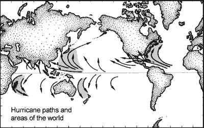
The map shows where hurricanes strike most frequently and the paths
they take. New Zealand used to be struck frequently in the past, but for
some time now, has not experienced any (Cyclone Bola 1983, Ola 1993). Cyclones
are born over warm water and they dissipate over land and over cold water
while raining down their amassed moisture.
When
hurricanes travel in one direction for some time, they send large waves
ahead that have a low frequency and high speed. Such waves reach deep and
their destructive power exceeds normal storm waves by far. Thus hurricanes
leave unerasable marks by creating barren areas. One would have thought
that the barrens will recover, but this is only partly so. Immediately
after denudation, the surface becomes covered in fine algae that prevent
other animals, like young corals from settling there. Then the grazing
armies of snails, sea urchins and fish take over, removing both algae and
whoever tries to settle there. So the barren areas are a stable habitat
form, comparable to the grasslands of the Serengeti. Only now and then
a large storm is needed to keep them barren.
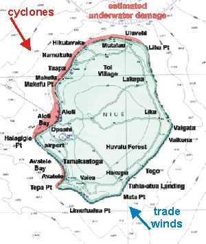
The red band on the map shows where Cyclone Heta caused its damage,
but other cyclones may arrive more from the NW, causing more damage to
Avatele in the south and less to Uluvehi in the north.
Underneath the fine algae grows another algal form, a coralline alga
known as pink paint. It grows flat leaves on the rock although
these are not true leaves like green plants have. These coralline leaves
are almost as hard as a coral skeleton, and over time they form reefs almost
indistinguishable from those built by corals. In fact, most coral rocks
contain a high ratio of coralline algae. The coralline algae grow over
anything and everything, and in doing so encapsulate corals and coral debris.
When the temperature becomes too low for corals (as during the ice ages),
the coralline algae will still grow but perhaps insufficiently to build
reefs. We have observed that the coral rocks of the Alofi Terrace on the
hurricane side, are of this type: jumbled and erratic (see also Niue's
geology).
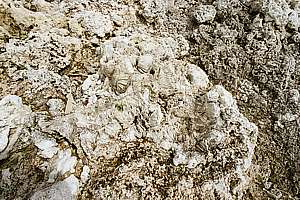
f220431: a clump of brain corals encapsulated with other
corals and debris into a coralline matrix with a jumbled structure.
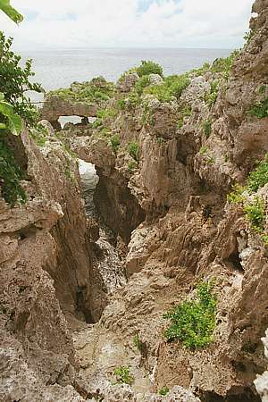
f220433: the sea has broken through the jumbled rock,
providing a glimpse of a cross-section through the Alofi Terrace at Alofi
on the hurricane side. Notice the platforms, walls, cavities and some brown
soil formation. It even shows some dripstone and vertical percolation channels.
f044036: apart from the leafy Porites corals in the
foreground, the rest of the rock shown here consists entirely of pink paint,
a reef-building coralline alga.
f044005: this rock face at Avatele was hit twenty years ago
and encrusting Porites corals begin to muscle in over the dominant
pink paint - until the next cyclone strikes.
Fishing around Niue No good records exist of what fish is caught around Niue. Niuean fishermen
seldom go out further than 2-3km from shore, and that brings them over
a very deep ocean, towards 5000m deep. Most if not all of their catches
consist of pelagic fish like wahoo (Acanthocybium solandri), dolphinfish
mahimahi (Coryphaena hippurus), barracuda, yellowfin tuna (Thunnus
albacares), albacore tuna (Thunnus alalunga), skipjack tuna
(Katsuwonus
pelamis), marlin, shark and a few others. But what do these fish feed
on and how much is there of both predators and prey?
From
the chapters above, it is clear that Niue is not able to catch the fishes
found around continents with continental shelves. Drawing a net through
the water may well cost more energy than the catch can pay for. So, longlining
for predatory fish is Niue's remaining option and judging from the experience
of local fishermen, this may well be possible on a large scale further
out over the entire EEZ of Niue. As mentioned before, scientists are puzzled
over the unexpected density of large predators in these infertile seas.
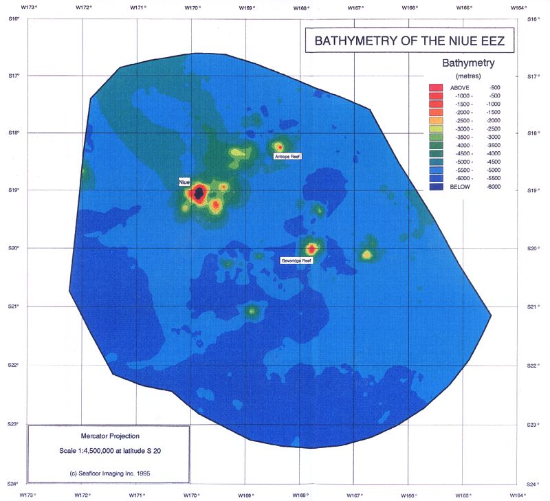
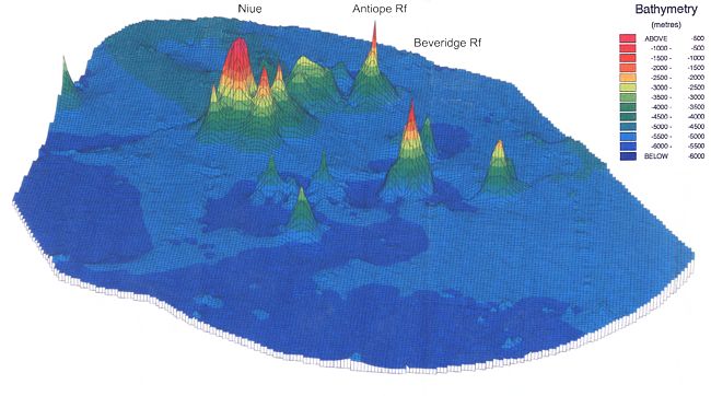
But some good information is available. Niue's EEZ counts ten sea mounts,
and these stir the water as the tide wave passes by, resulting in some
upwelling. However, most of these sea mounts are too deep to account for
this effect and some seamount fisheries have collapsed elsewhere (see more
detailed map [2]).
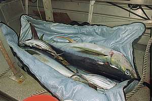
f221403: the harvest of two hours of early dawn trolling
with four baited lines. Two yellowfin tunas and two albacore tunas. Where
do they come from and what do they eat?
f220827: although Niueans do not swim well, many are skillful
fishers from their canoes. During one competition, they landed a 90kg yellowfin
tuna, a large shark and a large striped marlin. Imagine a fight with these
on a hand line from a wobbly canoe!
The density of fish over seamounts that somehow attracts them, depends
on [1]:
size and shape of seabottom discontinuity: the larger and the higher
the discontinuity of the sea bottom, the more the tide wave will be distorted,
resulting in stronger currents over larger distances. The orientation of
the discontinuity is also important. If a ridge or canyon lies across the
direction of the tidal wave, more turbulence can be expected. The map of
sea mounts suggests that the area close to Niue is likely to provide such
a discontinuity, since it is both large and located across the tide wave.
tidal amplitude: the larger the tide wave, the larger its effect
and the more water is stirred. Refer to the geography chapter for Niue's
bathymetry
(shape of the sea bottom) and its place in the spider
web of rotating tide waves. Niue's tide is about 1m, which is half
of the maximum experienced in the open Pacific Ocean. Only closer to indented
coasts will it become larger.
depth of the top of the sea mount: the closer the discontinuity
is to the surface of the water, the more mixing will reach sun-lit depths
for adequate plankton growth. Deep ocean mixing does not contribute to
productivity. Most of Niue's seamounts are too deep.
distance to coast: coasts provide nutrient rich waters and schooling
prey fish on which predators prey. Such schools may wander off into the
open ocean, and following them, their predators. Thus the closer to a large
shore, the more fish. However, Niue is very far from any such shore.
productivity of surrounding waters: the nearest centre of productivity
lies northward into the tongue of cool water where Coriolis forces cause
upwelling eddies. Predator and prey fish may wander out of this productivity
centre.
distance to other concentrated areas: the nearer to an area of productivity,
the more fish can be expected. Niue is located in a patch of clear, unproductive
water and currents bring in more of such water from the central part of
the South Pacific.
sea currents: sea currents bring food towards fish that congregate
and stay around sea mounts. The sea currents around Niue and its seamounts
are not known. Satellite maps suggest a tradewind-propelled current towards
the NW.
So, Niue is not well placed for catching fish that originated from
its own waters but many uncertainties remain. But what about strays, stragglers
and migratory fish arriving or passing through from other waters? Very
little is known of the migratory behaviour of fish schools and their predators.
Marine organisms usually wander up-stream because that is where smells
come from. Would Niue and Beveridge Reef provide a wake or trail for them
to swim towards? Obviously, more knowledge would be welcome.
What about the fish on outer reef slopes? There are ten seamounts with
raised sea bottoms, but most unfortunately do not reach above 1000m. Note
that in this respect the satellite bathymetry is uncertain as to the depths
of the tops of the sea mounts, and could well be out by 500-1000m, depending
on the track of the satellite. Traditional measurements are needed to confirm
the depths of these sea mounts, but even so, the fishery will be very small
indeed compared to a continental shelf fishery like New Zealand's.
The productivity table on right gives us estimates of what to expect.
Note that the productivity of the open ocean is comparable to that of a
desert, and the most productive seas over upwellings compare to temperate
forests, now replaced by the most productive arable zones of the world.
The quantities are green productivity, which on land leads to crops
directly and to livestock one step away (trophic level) with biomass losses
to wastes and energy for heating, movement and internal transport (breathing,
blood circulation). As a rule of thumb, each next trophic level contains
less biomass, usually 6-10 times less. In the sea where life begins with
microscopic plants (phytoplankton), it takes 3-5 trophic levels before
fish are large enough to be eaten by humans (table fish). Thus biomass
and productivity at this level is about 100 times less. The continental
shelf for instance is estimated to produce 2-6t/km2 of edible fish. The
open ocean accounts for less again, with a high degree of uncertainty.
Estimates for the kind of sustainable harvests that can be expected
from Niue's EEZ are:
New Zealand earns $1.2 billion annual export value caught mainly over a
continental shelf of 240,000km2, or $5000 per km2. If Niue's EEZ
is 50 times less productive (a reasonable estimate) then for its 390,000km2
EEZ, earnings up to $39 million in exports could be earned.
[other calculations waiting for further information]
[Reader please note that the above estimate must first be cross-checked
with other calculations before it becomes credible.]
But Niue does not have a safe harbour, so fishing boats must be small
enough to be lifted out of the water. For such boats to stay far out for
prolonged periods, storing ice and catch while travelling fast and economically,
and also light enough to be lifted out of the water, requires novel ship
designs.
The fish expected between 500-900m depth are: alfonsino (Beryx splendens),
bluenose grouper (Hyperoglyphe antarctica), pelagic armourhead (Pseudopentaceros
richardsoni), barracuta (Rexea antefurcata) and small sharks
(Squalus
spp, Centrophorus spp, Etmopterus spp) [2].
Deeper down the roundnose grenadier (Coryphaenoides rupestris)
can be caught to depths of 1200-2000m, but the deeper fish are all very
slow growing and do not easily support a sustainable fishery. Besides,
their flesh tends to be watery.
[1] Floor Anthoni (2004): Deductions from oceanographic
knowledge and facts, however not proved by scientific method.
[2] Satellite bathymetry survey of the EEZ of Niue. Seafloor
Imaging Inc. Govt of Niue, MAFF.
Read about our most recent discoveries about symbiotic
decomposition and mixotrophy which explain why the productivity of the
deep blue sea around Niue can be much higher than originally estimated.
Visit the Dark Decay Assay chapter.
 The
map shows global ocean temperatures for the Pacific Ocean in false colours
from purple to red. Absolute values for the sea temperature are thus hard
to guess but a clear picture emerges. As expected, the sea warms gradually
from the South Pole to the Equator in horizontal bands. But these bands
are not strictly horizontal, particularly the green one of the subtropics.
It curves all the way up to the equator along the coast of South America,
due to a strong ocean current moving up this coast. As a result, the Galapagos
Islands on the Equator are as cool as Sydney and Melbourne or even Auckland.
This tongue of cool water moves just south of the equator as it gradually
warms up.
The
map shows global ocean temperatures for the Pacific Ocean in false colours
from purple to red. Absolute values for the sea temperature are thus hard
to guess but a clear picture emerges. As expected, the sea warms gradually
from the South Pole to the Equator in horizontal bands. But these bands
are not strictly horizontal, particularly the green one of the subtropics.
It curves all the way up to the equator along the coast of South America,
due to a strong ocean current moving up this coast. As a result, the Galapagos
Islands on the Equator are as cool as Sydney and Melbourne or even Auckland.
This tongue of cool water moves just south of the equator as it gradually
warms up.
 Note
that the Sea Surface Temperature (SST) map was produced by infrared sensing
satellites that cannot pierce the water's surface (infrared light is absorbed
immediately). Thus the SST is indeed the temperature of a very shallow
surface layer, ignoring any cooler water direct underneath. One would expect
waves to mix the water column, which they do, but in the Niue area, average
wave height is rather low, as seen by this satellite map of average wave
heights. The bulge of warm water near Niue may thus not at all represent
the actual situation.
Note
that the Sea Surface Temperature (SST) map was produced by infrared sensing
satellites that cannot pierce the water's surface (infrared light is absorbed
immediately). Thus the SST is indeed the temperature of a very shallow
surface layer, ignoring any cooler water direct underneath. One would expect
waves to mix the water column, which they do, but in the Niue area, average
wave height is rather low, as seen by this satellite map of average wave
heights. The bulge of warm water near Niue may thus not at all represent
the actual situation.
 Look
at the sea around New Zealand, for instance. NZ is surrounded by a very
productive sea because of invisible currents south and north of it. One
current runs southward along Australia's east coast, mopping nutrients
into the New Zealand area. On its downward course, it encounters a cool
sea which forms a cold front, diverting its course to southern New Zealand.
Likewise, subantarctic currents experience this as a warm front as they
too are diverted towards southern NZ where turbulence causes upwellings
of nutrients. (See
Look
at the sea around New Zealand, for instance. NZ is surrounded by a very
productive sea because of invisible currents south and north of it. One
current runs southward along Australia's east coast, mopping nutrients
into the New Zealand area. On its downward course, it encounters a cool
sea which forms a cold front, diverting its course to southern New Zealand.
Likewise, subantarctic currents experience this as a warm front as they
too are diverted towards southern NZ where turbulence causes upwellings
of nutrients. (See 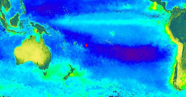
 Hurricanes
or tropical cyclones as they are called in our area of the world,
do not strike frequently (Niue 1959, 1960, 1970, 1989, 1990, 2004) and
therefore it is hard to believe that they have such a pronounced effect
on the underwater environment. Not only do they affect the visual aspect
of the seascape, but we observed that they also affect the structure of
the cemented coral rocks that built Niue, and that they have been doing
this for as long as Niue exists (1-3 million years). However, no scientific
proof is yet available.
Hurricanes
or tropical cyclones as they are called in our area of the world,
do not strike frequently (Niue 1959, 1960, 1970, 1989, 1990, 2004) and
therefore it is hard to believe that they have such a pronounced effect
on the underwater environment. Not only do they affect the visual aspect
of the seascape, but we observed that they also affect the structure of
the cemented coral rocks that built Niue, and that they have been doing
this for as long as Niue exists (1-3 million years). However, no scientific
proof is yet available.
 When
hurricanes travel in one direction for some time, they send large waves
ahead that have a low frequency and high speed. Such waves reach deep and
their destructive power exceeds normal storm waves by far. Thus hurricanes
leave unerasable marks by creating barren areas. One would have thought
that the barrens will recover, but this is only partly so. Immediately
after denudation, the surface becomes covered in fine algae that prevent
other animals, like young corals from settling there. Then the grazing
armies of snails, sea urchins and fish take over, removing both algae and
whoever tries to settle there. So the barren areas are a stable habitat
form, comparable to the grasslands of the Serengeti. Only now and then
a large storm is needed to keep them barren.
When
hurricanes travel in one direction for some time, they send large waves
ahead that have a low frequency and high speed. Such waves reach deep and
their destructive power exceeds normal storm waves by far. Thus hurricanes
leave unerasable marks by creating barren areas. One would have thought
that the barrens will recover, but this is only partly so. Immediately
after denudation, the surface becomes covered in fine algae that prevent
other animals, like young corals from settling there. Then the grazing
armies of snails, sea urchins and fish take over, removing both algae and
whoever tries to settle there. So the barren areas are a stable habitat
form, comparable to the grasslands of the Serengeti. Only now and then
a large storm is needed to keep them barren.