by Dr J Floor Anthoni (2000)
www.seafriends.org.nz/oceano/storms.htm
Large storms and hurricanes do not occur often,
but when they do, they cause much damage. The force of the wind can be
devastating by itself, but combined with that of the waves and a storm
surge, it can make living at the coast a risky affair. Knowing this risk
and how it arises, could save lives.
Winds circulate from the warm tropics to the cooler temperate regions.
Water vapour is capable of transferring massive amounts of energy to power
tropical cyclones.
A tropical cyclone brings a fourfold threat: wind + waves + surge +
rain. Its power is often underestimated. The under water world is affected
mainly by waves.
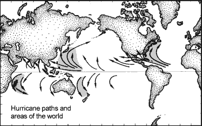
Tropical
cyclones have their origins in the tropics but are not found in a band
4ºS to 4ºN around the equator (why not? see below). In Asia they
are called typhoons (Gk tuphon= whirlwind, and Chinese tai
fung= big wind) and in America hurricanes (Spanish huracan).
The map shows hurricane paths and their areas. The northern hurricane zone
from 4º to 35ºN is almost twice as wide as its corresponding
southerly zone from 4º to 22ºS. New Zealand lies outside this
zone but is regularly visited by hurricanes as they lose their energy and
rain. Storms exceeding 65 knot (115 km/hr) winds, qualify as tropical cyclones,
but their destructive power increases rapidly with wind speed. Tropical
cyclones may last from a few hours to as long as two weeks, their average
life being 6 days.
This
map shows hurricane tracks over New Zealand in the early part of the 20th
century. Note that the North Island is more likely to be hit than the South
Island. Also note that storms are more prevalent during certain decades
and seasons. Hurricanes affecting New Zealand are not very strong, as judged
by the Saffir-Simpson hurricane scale (see below). Only on two occasions
did hurricanes of category one (970 mbar) reach NZ (bold print). As the
world climate changes, more and heavier storms can be expected.
Hurricanes do not occur in a narrow band around the equator because
here the coriolis forces are zero (they work up and down). Thus
winds cannot focus into an area of low pressure and spin around. Hurricanes
do not occur further than 35 degrees from the equator because there the
seas are too cold to power them. As hurricanes move from the warm waters
nearest the equator outward to the cooler regions, coriolis forces
increase gradually, forcing them to spin faster and tighter, thereby increasing
their destructive power. Cyclones thus become most destructive shortly
before the end of their paths. For an explanation about how coriolis forces
or geostrophic forces work, read circulation/deflection.
World map showing primary and secondary storm tracks
and average atmospheric pressure.
Courtesy Encyclopedia Britannica.
How do tropical cyclones form? As winds transfer heat from the warm areas on the planet to the cooler
ones, they swirl around while they are deflected by Coriolis forces, caused
by the rotation of the Earth. In the Northern Hemisphere, moving objects
are deflected to the right, resulting in low pressure areas (cyclones)
cycling anticlockwise. In the Southern Hemisphere, this is the reverse.
The extraordinary property of water, to require 400 heat calories in order
to evaporate one gram (to heat one gram by one degree, requires one calorie),
makes water vapour a powerful agent in the transfer of energy through the
atmosphere. A tropical cyclone is born from a low pressure area by the
interplay of rising and falling winds, warming and cooling air and the
transfer of energy by water molecules. The result is a system of swirling
winds that increase as they approach the eye, but inside the eye of the
storm, it is calm. Powered by heat from evaporation, tropical cyclones
can grow only above warm sea water. Once they pass overland or over colder
water, they rapidly lose strength.
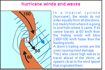
In
a stationary tropical cyclone, winds arriving from all directions, cause
waves to radiate out in all directions. But once the system moves, the
pattern changes as shown in this diagram for a Southern Hemisphere cyclone.
The most powerful winds now arise from where the centre came from, sending
large waves out ahead of the storm. The wind also pushes the water ahead
of it, causing the water level to rise (storm surge). The size of this
storm surge and its waves, depends largely on how the storm's centre has
been moving, for the rotating winds around it are capable of cancelling
each other's waves.
Note that storm sized winds (but not of hurricane force) blowing for
a long time from one direction, are capable of developing sea states equally
destructive as hurricanes.
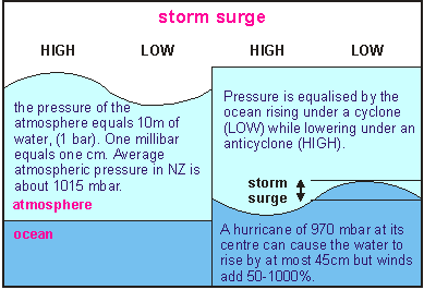
A
storm surge has two components: the pressure difference between high and
low pressure areas and the water level swept up by winds. The diagram attempts
to quantify the barometric effect. In the left half, the ocean is flat
and the atmospheric pressure between a high and a low is represented as
if the atmosphere extended further out in space. The atmosphere's pressure
is almost equal to that of 10 m of water. It is expressed in bar, where
one bar is the average atmospheric pressure on Earth. Due to the centrifugal
force of a rotating Earth, the atmospheric pressure is less at the equator
than at the poles. In New Zealand, it is about 1015 millibar.
The effect of a high pressure area is that of pushing the sea level
down. A hurricane of category one (970 mbar) is thus theoretically capable
of causing a 45 cm storm surge (1015-970). In practice, winds are the overriding
factor (see below).
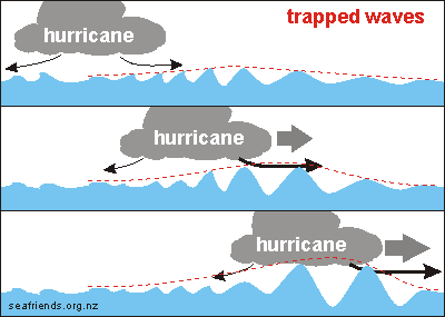
Trapped waves When
a hurricane moves ever faster in one direction, very high waves can form
underneath, arriving without warning. It is thought that this may have
happened in the case of Cyclone Heta that destroyed much of the island
state of Niue [1] but how does this work? The drawing shown here has three
panels. The top panel shows the waves radiating out from a stationary cyclone
and the next two panels of what happens when it 'chases' waves in one direction.
With a stationary cyclone, the winds radiate out in all directions
at equal strengths. It causes waves to build up toward the periphery of
the cyclone and then to gradually diminish as they radiate out. As they
move further away, their heights diminish but their wave lengths increase,
causing them to run ever faster. Such waves can cover thousands of kilometres
but they are always preceded by small waves before the bigger ones arrive.
When a hurricane moves, its leading winds become stronger while its
trailing winds become weaker. The stronger forward winds build up higher
waves from the ones that would otherwise have escaped. However, as their
wave lengths increase, they run away ever faster. Thus when a hurricane
accelerates to keep up with them, these wave become monstrous without there
being smaller waves to warn of their arrival.
The important consequence of trapped waves is that the strength
of a hurricane's waves is difficult to predict. For instance a category
4 hurricane can arrive with waves equal to a category 5 hurricane or larger.
[1] Callaghan David, Jeff Callaghan, Peter Nielsen and
Tom Baldock (2006): GENERATION OF EXTREME WAVE CONDITIONS FROM AN ACCELERATING
TROPICAL CYCLONE, ICCE 2006 Abstract Nr 1496
Cyclone Heta:
Indepth article on this web site about Cyclone Heta and the damage it caused.
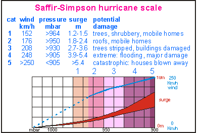
What are a storm's consequences? Because
both winds and waves increase rapidly with wind speed, scientists Saffir
and Simpson have devised a hurricane scale in categories, each category
being twice as destructive as the previous. The severity of a hurricane
can be related to its barometric pressure, but a large degree of variation
remains.
Note that the maximum wind speed increases in a gradual fashion but
the storm surge increases more rapidly. Maximum wave heights of a possible
fully developed sea are not shown. In the table, the damage caused by hurricane
winds is shown but not that of hurricane seas, which can inflict far more
damage, although only to coastal settlements. Also the torrential rains
from a weakening hurricane, can cause more damage than that caused by its
winds.
The
threat of hurricanes to coastal dwellings does not come from wind alone.
In this picture a typical situation is shown of many a coastal settlement,
which are only 2m above spring high tide level. A storm may bring a one
metre surge with 6 metre waves, allowing waves to nip over coastal walls
and revetments, but a class three hurricane arriving with a 3m surge and
12m waves, will flood these settlements during high tide, causing major
damage. The storm surge lifts the water high above the beach, allowing
higher waves to ride much further inland than usual.
Large storms always cause damage to beaches and dunes but these can
repair themselves slowly after the event (See dunes
& beaches). The high waves stir the sand deep down and up-root
marine organisms living there. Both the sand and the organisms are transported
towards the beach, causing wash-ups, sometimes of disastrous proportions.
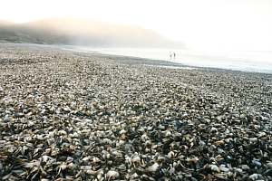
In March 1995, a large storm caused a massive washup of fan
shells (Atrina) on Pakiri Beach near Te Arai Point. The beach was
covered in a layer 500m long, 70m wide and 0.5m thick. These shells were
all equally old, about 3 years, judged by their growth rings. They all
disappeared 4 days later.
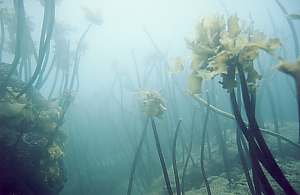
On a normally sheltered cliff face near Leigh Harbour, kelp
plants flourished until a rare south-easterly storm tore their canopies
off. These rocks are normally bared by the grazing of sea urchins, but
during a favourable calm period, the kelp managed to establish itself here.
Storms leave their unmistakable signature in the underwater environment,
both beneficial and detrimental. Overall, one sees more species diversity
in sheltered areas than in exposed areas. Here are some of the important
effects:
Beach erosion: the beach defends only against normal waves and tides.
Large storms, however, attack the beach at a higher level and with larger
waves. The beach sacrifices its foredune, which will later be rebuilt by
the sea wind. Large storms transport new sand towards the beach, enabling
the beach to grow in the calm period following the storm.
Shell washups: the sandy bottom in front of beaches is ploughed
up by the waves, causing sand and burrowing organisms to be transported
towards the beach. The sand remains at the bottom of the beach but seashells
and other organisms are washed up on the beach. Organisms burrowing fast
or deep enough, are capable of staying secure. Occasional storms thus cause
habitat zoning in the sandy bottom.
Kelp washups: in calm conditions, kelp seedlings may settle in areas
where they normally won't be able to survive. The first big storm rips
them off the rock completely or tears their canopies. The hapless plants
gather in masses in depressions of the shore (where they survive) or they
are washed up on beaches (where they die). Particularly the stalked kelp
(Ecklonia radiata) is susceptible.
Turning stones: on the rocky shore in the intertidal range, rocks
are often flipped, disturbing the mini habitats underneath.
Sand blasting: close to the bottom, the waves, mixed with sand,
do their sand blasting, scouring sponges and other sessile organisms. Where
such organisms are partly suffocated by mud or plankton blooms, the sand
blasting often works remedially, cleaning them. In areas of heavy sand
blasting, only robust sponges such as the boring sponge (Cliona celata)
can survive.
Turbidity: In polluted areas, characterised by fine particles (mud)
mixed in with the sand, seas become turbid while releasing nutrients (and
sometimes poisonous hydrogen-sulfide gas H2S) from the muddy sand. The
polluted water then kills sensitive marine organisms.
Water stirring: large storms are able to stir the water so well
that the thermocline disappears, allowing cold nutrient-rich bottom water
to mix with the warm nutrient-depleted surface water, causing plankton
blooms within a week after the storm.
Mud torrents: tropical cyclones are also accompanied by torrential
rains that cause massive erosion to the land, filling rivers with torrents
of fast flowing mud. The mud ends up in the sea where it pollutes the water,
suffocating water-breathing organisms and absorbing the sunlight, necessary
for algae to grow. It was observed that cyclone Bola deposited a layer
of mud, 15 cm deep on an exposed coast (the Goat Island marine reserve),
taking seven years of average storms to clear it.
Plankton blooms: as the mud releases its nutrients to the sea, and
nutrients from deeper layers are stirred up to the surrface, dense plankton
blooms can occur 3-10 days later, threatening all marine organisms. See
the chapter on decay.
 Tropical
cyclones have their origins in the tropics but are not found in a band
4ºS to 4ºN around the equator (why not? see below). In Asia they
are called typhoons (Gk tuphon= whirlwind, and Chinese tai
fung= big wind) and in America hurricanes (Spanish huracan).
The map shows hurricane paths and their areas. The northern hurricane zone
from 4º to 35ºN is almost twice as wide as its corresponding
southerly zone from 4º to 22ºS. New Zealand lies outside this
zone but is regularly visited by hurricanes as they lose their energy and
rain. Storms exceeding 65 knot (115 km/hr) winds, qualify as tropical cyclones,
but their destructive power increases rapidly with wind speed. Tropical
cyclones may last from a few hours to as long as two weeks, their average
life being 6 days.
Tropical
cyclones have their origins in the tropics but are not found in a band
4ºS to 4ºN around the equator (why not? see below). In Asia they
are called typhoons (Gk tuphon= whirlwind, and Chinese tai
fung= big wind) and in America hurricanes (Spanish huracan).
The map shows hurricane paths and their areas. The northern hurricane zone
from 4º to 35ºN is almost twice as wide as its corresponding
southerly zone from 4º to 22ºS. New Zealand lies outside this
zone but is regularly visited by hurricanes as they lose their energy and
rain. Storms exceeding 65 knot (115 km/hr) winds, qualify as tropical cyclones,
but their destructive power increases rapidly with wind speed. Tropical
cyclones may last from a few hours to as long as two weeks, their average
life being 6 days.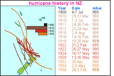 This
map shows hurricane tracks over New Zealand in the early part of the 20th
century. Note that the North Island is more likely to be hit than the South
Island. Also note that storms are more prevalent during certain decades
and seasons. Hurricanes affecting New Zealand are not very strong, as judged
by the Saffir-Simpson hurricane scale (see below). Only on two occasions
did hurricanes of category one (970 mbar) reach NZ (bold print). As the
world climate changes, more and heavier storms can be expected.
This
map shows hurricane tracks over New Zealand in the early part of the 20th
century. Note that the North Island is more likely to be hit than the South
Island. Also note that storms are more prevalent during certain decades
and seasons. Hurricanes affecting New Zealand are not very strong, as judged
by the Saffir-Simpson hurricane scale (see below). Only on two occasions
did hurricanes of category one (970 mbar) reach NZ (bold print). As the
world climate changes, more and heavier storms can be expected.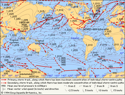
 In
a stationary tropical cyclone, winds arriving from all directions, cause
waves to radiate out in all directions. But once the system moves, the
pattern changes as shown in this diagram for a Southern Hemisphere cyclone.
The most powerful winds now arise from where the centre came from, sending
large waves out ahead of the storm. The wind also pushes the water ahead
of it, causing the water level to rise (storm surge). The size of this
storm surge and its waves, depends largely on how the storm's centre has
been moving, for the rotating winds around it are capable of cancelling
each other's waves.
In
a stationary tropical cyclone, winds arriving from all directions, cause
waves to radiate out in all directions. But once the system moves, the
pattern changes as shown in this diagram for a Southern Hemisphere cyclone.
The most powerful winds now arise from where the centre came from, sending
large waves out ahead of the storm. The wind also pushes the water ahead
of it, causing the water level to rise (storm surge). The size of this
storm surge and its waves, depends largely on how the storm's centre has
been moving, for the rotating winds around it are capable of cancelling
each other's waves.
 A
storm surge has two components: the pressure difference between high and
low pressure areas and the water level swept up by winds. The diagram attempts
to quantify the barometric effect. In the left half, the ocean is flat
and the atmospheric pressure between a high and a low is represented as
if the atmosphere extended further out in space. The atmosphere's pressure
is almost equal to that of 10 m of water. It is expressed in bar, where
one bar is the average atmospheric pressure on Earth. Due to the centrifugal
force of a rotating Earth, the atmospheric pressure is less at the equator
than at the poles. In New Zealand, it is about 1015 millibar.
A
storm surge has two components: the pressure difference between high and
low pressure areas and the water level swept up by winds. The diagram attempts
to quantify the barometric effect. In the left half, the ocean is flat
and the atmospheric pressure between a high and a low is represented as
if the atmosphere extended further out in space. The atmosphere's pressure
is almost equal to that of 10 m of water. It is expressed in bar, where
one bar is the average atmospheric pressure on Earth. Due to the centrifugal
force of a rotating Earth, the atmospheric pressure is less at the equator
than at the poles. In New Zealand, it is about 1015 millibar.
 When
a hurricane moves ever faster in one direction, very high waves can form
underneath, arriving without warning. It is thought that this may have
happened in the case of Cyclone Heta that destroyed much of the island
state of Niue [1] but how does this work? The drawing shown here has three
panels. The top panel shows the waves radiating out from a stationary cyclone
and the next two panels of what happens when it 'chases' waves in one direction.
When
a hurricane moves ever faster in one direction, very high waves can form
underneath, arriving without warning. It is thought that this may have
happened in the case of Cyclone Heta that destroyed much of the island
state of Niue [1] but how does this work? The drawing shown here has three
panels. The top panel shows the waves radiating out from a stationary cyclone
and the next two panels of what happens when it 'chases' waves in one direction.
 Because
both winds and waves increase rapidly with wind speed, scientists Saffir
and Simpson have devised a hurricane scale in categories, each category
being twice as destructive as the previous. The severity of a hurricane
can be related to its barometric pressure, but a large degree of variation
remains.
Because
both winds and waves increase rapidly with wind speed, scientists Saffir
and Simpson have devised a hurricane scale in categories, each category
being twice as destructive as the previous. The severity of a hurricane
can be related to its barometric pressure, but a large degree of variation
remains.
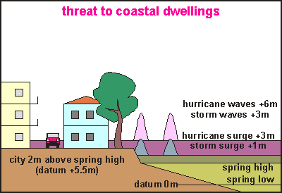 The
threat of hurricanes to coastal dwellings does not come from wind alone.
In this picture a typical situation is shown of many a coastal settlement,
which are only 2m above spring high tide level. A storm may bring a one
metre surge with 6 metre waves, allowing waves to nip over coastal walls
and revetments, but a class three hurricane arriving with a 3m surge and
12m waves, will flood these settlements during high tide, causing major
damage. The storm surge lifts the water high above the beach, allowing
higher waves to ride much further inland than usual.
The
threat of hurricanes to coastal dwellings does not come from wind alone.
In this picture a typical situation is shown of many a coastal settlement,
which are only 2m above spring high tide level. A storm may bring a one
metre surge with 6 metre waves, allowing waves to nip over coastal walls
and revetments, but a class three hurricane arriving with a 3m surge and
12m waves, will flood these settlements during high tide, causing major
damage. The storm surge lifts the water high above the beach, allowing
higher waves to ride much further inland than usual.